| My Groups | typhoon2000asiapac_stormlist Main Page | |

Typhoon2000 STORM UPDATE #19
Name: TYPHOON CHANCHU [CALOY/02W/0601]
Issued: 7:00 AM MANILA TIME (23:00 GMT) THU 18 MAY 2006
Next Update: 7:00 AM (23:00 GMT) THU 18 MAY 2006
Source: JTWC TROPICAL CYCLONE WARNING #037
_______________________________________________________________________
Next Update: 7:00 AM (23:00 GMT) THU 18 MAY 2006
Source: JTWC TROPICAL CYCLONE WARNING #037
_______________________________________________________________________
TYPHOON CHANCHU (CALOY) WEAKENS INTO A CATEGORY ONE TYPHOON AS
IT MAKES LANDFALL ALONG SOUTHWESTERN FUJIAN OR JUST BETWEEN THE
CITIES OF SHANTOU AND XIAMEN.
+ FORECAST OUTLOOK: CHANCHU is expected to continue moving across
Fujian Province as a weakened Tropical Storm later today. Resi-
dents of Southern China (Fujian Provinces) are advised to take
precautionary measures as the Category 1 typhoon passes by...
mapping out disaster preparedness plans during CHANCHU's approach
must be completed now to avoid loss of lives and properties.
+ EFFECTS: CHANCHU's inner core has begun to decay while inter-
acting across the Fujian landscape..however, strong winds and
heavy rains can still be felt across SW and Southern Fujian
today. The inner and outer rainbands continues to spread across
Southern China particularly Hong Kong, Eastern Guangdong and
Western Fujian. These rainbands particularly the inner bands
will continue to bring moderate to heavy rainfall with moderate
to strong, damaging winds and could produce flying debris, life-
threatening flash floods and mudslides along river banks, low-
lying areas and mountain slopes over the affected areas. Resi-
dents residing along the coastal beachfront areas of Southern
China are advised to seek higher grounds due to possible high
waves from the sea. Coastal Storm Surge flooding from 4 to 5
feet can be expected along the path of CHANCHU advising all
sea vessels to remain at port and avoid passing over it.
+ CURRENT MONSOON INTENSITY: This storm is currently enhancing
the Southwesterly Windflow bringing moderate to sometimes heavy
rains in some sections of the Philippines. These rains may
produce life-threatening flash floods and mudslides along river
banks, low-lying areas and mountain slopes of the affected areas.
Important Note: Please keep in mind that the above forecast outlook,
effects & current monsoon intensity changes every 06 to 12 hours!
_______________________________________________________________________
TIME/DATE: 5:00 AM MANILA TIME (21:00 GMT) 18 MAY
LOCATION OF CENTER: LATITUDE 24.1º N...LONGITUDE 117.4º E
DISTANCE 1: 105 KM (56 NM) NE OF SHANTOU, CHINA
TIME/DATE: 5:00 AM MANILA TIME (21:00 GMT) 18 MAY
LOCATION OF CENTER: LATITUDE 24.1º N...LONGITUDE 117.4º E
DISTANCE 1: 105 KM (56 NM) NE OF SHANTOU, CHINA
DISTANCE 2: 85 KM (45 NM) ESE OF XIAMEN, CHINA
DISTANCE 3: 385 KM (208 NM) ENE OF HONG KONG, CHINA
MAX SUSTAINED WINDS [1-MIN AVG]: 140 KM/HR (75 KTS)
PEAK WIND GUSTS: 165 KM/HR (90 KTS)
MINIMUM CENTRAL PRESSURE (est.): 967 MILLIBARS (hPa)
MAX WAVE HEIGHT**: 17 FEET (5.1 METERS)
SAFFIR-SIMPSON SCALE: CATEGORY 1
RECENT MOVEMENT: NNE @ 19 KM/HR (10 KTS)
GENERAL DIRECTION: FUJIAN PROVINCE
STORM'S SIZE (IN DIAMETER): 870 KM (470 NM)/LARGE
VIEW T2K TRACKING MAP: 5 AM THU MAY 18
TSR WIND PROBABILITIES: CURRENT TO 24 HRS LEAD
PHILIPPINE STORM SIGNALS*: NONE
09-21 HR. FORECAST:
> 2 PM (06 GMT) 18 MAY: 26.3N 118.7E / 85-100 KPH [EXTRATROPICAL]
> 2 AM (18 GMT) 19 MAY: 29.2N 120.8E / 55-75 KPH
REMARKS: 2 AM (18 GMT) 18 MAY POSITION: 23.4N 117.0E.
^ ANIMATED SATELLITE IMAGERY AND A MICROWAVE PASS INDICATE
THAT TY CHANCHU HAS BEGUN TRANSITIONING TO AN EXTRATROPICAL
CYCLONE. TY CHANCHU CONTINUES TO TRACK POLEWARD ALONG THE
WESTERN PERIPHERY OF A MID-LEVEL HIGH PRESSURE STEERING
RIDGE CENTERED EAST OF TAIWAN. TY CHANCHU IS FORECAST TO
TURN NORTHEASTWARD IN RESPONSE TO A WEAKNESS DEVELOPING
IN THE STEERING RIDGE CAUSED BY AN APPROACHING MIDLATITUDE
LOW PRESSURE TROUGH...(more info)
>> CHANCHU {pronounced: chan~chu}, meaning: Pearl, a smooth,
rounded lustrous deposit formed in the shells of certain
oysters and is often used for jewelry. Many Macau souvenirs
are made of it. Name contributed by: Macau, China
_______________________________________________________________________
EYEWALL PASSAGE FORECAST TIMES (EPFT):
Southern Fujian: Ongoing until 9AM Thu.
Note: The EyeWall - is the ring of rain clouds surrounding the "EYE" of a Typhoon. It is here where
the strongest winds and heaviest rain of a typhoon can be found. EPFT will show what local times
on a given area the most damaging winds and heaviest rainfall could be experienced. EPFT
changes everytime a new warning synopsis is issued. Important: This is only an estimate
analysis, do not use this for life/death decisions.
_________________________________________________________________________________
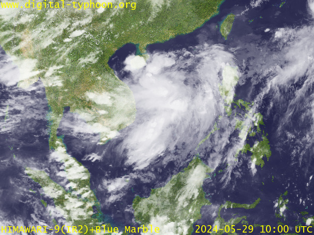
RECENT MTSAT-1R SATELLITE IMAGE:

> Image source: Digital-Typhoon.org (Nat'l. Institute of Informatics) (http://www.digital-typhoon.org)
__________________________________________________________________________________________
LATEST T2K TRACKING CHART:

_______________________________________________________________________________________
NOTES:

> Image source: Digital-Typhoon.org (Nat'l. Institute of Informatics) (http://www.digital-typhoon.org)
__________________________________________________________________________________________
LATEST T2K TRACKING CHART:

_______________________________________________________________________________________
NOTES:
^ - JTWC commentary remarks (for Meteorologists) from their latest warning.
* - Based on PAGASA's Philippine Storm Warning Signals, # 4 being the
highest. Red letters indicate new areas being hoisted. For more
explanations on these signals, visit: http://www.typhoon2000.ph/signals.htm
** - Based on the Tropical Cyclone's Sea Wave Height near its center.
__________________________________________________________________________________________
>> To know the meteorological terminologies and acronyms used on
this update visit the ff:
http://typhoon2000.ph/tcterm.htm
http://www.nhc.noaa.gov/aboutgloss.shtml
http://www.srhnoaa.gov/oun/severewx/glossary.php
http://www.srh.weather.gov/fwd/glossarynation.html
http://www.nhc.noaa.gov/acronyms.shtml
__________________________________________________________________________________________
T2K Mobile: receive the latest storm updates directly to your mobile phones! To know more,
Send T2K HELP to: 2800 (GLOBE & TM) | 386 (SMART & TNT) | 2288 (SUN)
Powered by: Synermaxx
__________________________________________________________________________________________
For the complete details on the TY CHANCHU (CALOY)...go visit our website @:
> http://www.typhoon2000.com
> http://www.maybagyo.com
:: Kindly view our site's disclaimer at: http://www.typhoon2000.ph/disclaimer.htm
YAHOO! GROUPS LINKS
- Visit your group "typhoon2000asiapac_stormlist" on the web.
- To unsubscribe from this group, send an email to:
typhoon2000asiapac_stormlist-unsubscribe@yahoogroups.com
- Your use of Yahoo! Groups is subject to the Yahoo! Terms of Service.
No comments:
Post a Comment