Typhoon2000 STORM UPDATE #04
Name: TROPICAL STORM KAEMI [06W/0605]
Issued: 7:00 AM MANILA TIME (23:00 GMT) THU 20 JULY 2006
Next Update: 7:00 PM (11:00 GMT) THU 20 JULY 2006
Source: JTWC TROPICAL CYCLONE WARNING #008
_______________________________________________________________________
Next Update: 7:00 PM (11:00 GMT) THU 20 JULY 2006
Source: JTWC TROPICAL CYCLONE WARNING #008
_______________________________________________________________________
...KAEMI (06W) GAINING MORE STRENGTH AS IT TRACKS WEST-
WARD OVER THE PAST 12 HOURS...TO ENTER THE EASTERN BOUN-
DARY OF THE PHILIPPINE AREA OF RESPONSIBILITY (PAR)
TONIGHT...EYES EXTREME NORTHERN LUZON.
WARD OVER THE PAST 12 HOURS...TO ENTER THE EASTERN BOUN-
DARY OF THE PHILIPPINE AREA OF RESPONSIBILITY (PAR)
TONIGHT...EYES EXTREME NORTHERN LUZON.
+ FORECAST OUTLOOK: New outlook has been issued...KAEMI
is now expected to continue tracking WNW & shall become
a Typhoon in 36 hours. The 4 to 5-day Long-Range Fore-
cast shows the storm reaching wind speeds of 130 km/hr
as it approaches the Batanes Group of Islands early
morning Monday, July 24.
+ EFFECTS: Outer bands of this system continues to expand,
however, the Southern Mariana Islands including Guam are
just along the extreme eastern portion of this cloud bands.
So, improving weather conditions can be expected late today.
Meanwhile, Yap & Ulithi Islands is currently under these
bands. These islands shall expect rainfall with gale-force
winds of up to 60 km/hr today as KAEMI passes to the North.
Moderate to rough seas with dangerous surf can be expected
over Yap & Ulithi islands throughout the day.
+ TROPICAL CYCLONE WATCH: The Tropical Disturbance (LPA/99W
/1008 mb) over the South China Sea remains disorganized and
was located approx 225 km West of Dagupan City (16.0N
118.2E)..moving WNW slowly. This system which is embedded
within the active Inter-Tropical Convergence Zone (ITCZ)
is currently inducing rain-bearing clouds across Central
& Southern Luzon including Metro Manila.
outlook, effects, current monsoon intensity, and tropical
cyclone watch changes every 06 to 12 hours!
_______________________________________________________________________
TIME/DATE: 5:00 AM MANILA TIME (21:00 GMT) 20 JULY
LOCATION OF CENTER: LATITUDE 12.0º N...LONGITUDE 138.5º E {SatFix}
DISTANCE 1: 1,425 KM (770 NM) EAST OF SAMAR, PH
DISTANCE 2: 280 KM (150 NM) NNE OF COLONIA, YAP, FSM
DISTANCE 3: 380 KM (205 NM) EAST OF P.A.R.
MAX SUSTAINED WINDS [1-MIN AVG]: 85 KM/HR (45 KTS)
PEAK WIND GUSTS: 100 KM/HR (55 KTS)
MINIMUM CENTRAL PRESSURE (est.): 991 MILLIBARS (hPa)
MAX WAVE HEIGHT**: 15 FEET (4.5 METERS)
SAFFIR-SIMPSON SCALE: N/A
RECENT MOVEMENT: WEST @ 17 KM/HR (09 KTS)
GENERAL DIRECTION: CAGAYAN-BATANES-TAIWAN
STORM'S SIZE (IN DIAMETER): 520 KM (280 NM)/AVERAGE
VIEW T2K TRACKING MAP: 5 AM THU JULY 20
TSR WIND PROBABILITIES: CURRENT TO 120 HRS LEAD
PHILIPPINE STORM SIGNALS*: N/A
09-21 HR. FORECAST:
> 2 PM (06 GMT) 20 JULY: 13.1N 137.0E / 100-130 KPH
> 2 AM (18 GMT) 21 JULY: 14.5N 134.9E / 110-140 KPH
REMARKS: 2 AM (18 GMT) 20 JULY POSITION: 12.1N 138.9E.
^TS KAEMI IS FORECAST TO CONTINUE TRACKING ALONG THE
SOUTHWESTERN PERIPHERY OF A LARGE MID-LEVEL STEERING
ANTICYCLONE ANCHORED TO THE NORTHEAST. A SLIGHT TURN
POLEWARD IS FORECAST TO OCCUR AFTER 24 HOURS DUE TO A
SHORT-LIVED WEAKENING OF THE STEERING RIDGE. TS KAEMI
WILL AGAIN BEGIN TO TRACK WEST-NORTHWESTWARD AFTER 48
HOURS AS THE STEERING RIDGE REINTENSIFIES AND BUILDS
WESTWARD...(more info)
>> KAEMI {pronounced: gae~mi}, meaning: An ant. A very
small insect that lives in highly organized groups.
It often appears in Korean fairy tales as a symbol
of diligence. Name contributed by: Republic of Korea.
_________________________________________________________________________________
_________________________________________________________________________________
LATEST T2K TRACKING CHART:

_______________________________________________________________________________________
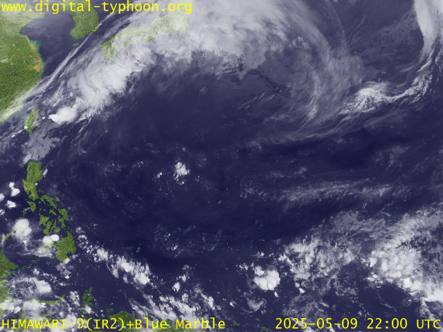
RECENT MTSAT-1R SATELLITE IMAGE:

> Image source: Digital-Typhoon.org (Nat'l. Institute of Informatics, Japan) (http://www.digital-typhoon.org)
__________________________________________________________________________________________
NOTES:
^ - JTWC commentary remarks (for Meteorologists) from their
latest warning.
latest warning.
* - Based on PAGASA's Philippine Storm Warning Signals,
# 4 being the highest. Red letters indicate new areas
being hoisted. For more explanations on these signals,
visit: http://www.typhoon2000.ph/signals.htm
** - Based on the Tropical Cyclone's Sea Wave Height near
its center.
__________________________________________________________________________________________
>> To know the meteorological terminologies and acronyms
used on this update visit the ff:
http://typhoon2000.ph/tcterm.htm
http://www.nhc.noaa.gov/aboutgloss.shtml
http://www.srhnoaa.gov/oun/severewx/glossary.php
http://www.srh.weather.gov/fwd/glossarynation.html
http://www.nhc.noaa.gov/acronyms.shtml
__________________________________________________________________________________________
:: Typhoon2000.com (T2K) Mobile >> Powered by: Synermaxx
Receive the latest storm updates directly to your mobile phones! To know more:
Send T2K HELP to: 2800 (GLOBE & TM) | 216 (SMART & TNT) | 2288 (SUN)
__________________________________________________________________________________________
For the complete details on the TS KAEMI (06W)...go visit
our website @:
> http://www.typhoon2000.com
> http://www.maybagyo.com
Visit Your Group | Yahoo! Groups Terms of Use | Unsubscribe
New Message Search
Find the message you want faster. Visit your group to try out the improved message search.
SPONSORED LINKS
.
__,_._,___
No comments:
Post a Comment