
Typhoon2000 STORM UPDATE #002
Name: TROPICAL STORM CHEBI [QUEENIE/23W/0620]
Issued: 7:00 AM MANILA TIME (23:00 GMT) FRI 10 NOVEMBER 2006
Next Update: 7:00 PM (11:00 GMT) FRI 10 NOVEMBER 2006
Source: JTWC TROPICAL CYCLONE WARNING #004
_______________________________________________________________________
Next Update: 7:00 PM (11:00 GMT) FRI 10 NOVEMBER 2006
Source: JTWC TROPICAL CYCLONE WARNING #004
____________
TROPICAL STORM CHEBI (QUEENIE) HAS ACCELERATED FURTHER
TOWARDS THE WEST, CLOSER TO AURORA-NORTHERN QUEZON AREA.
THREAT TO LUZON CONTINUES TO INCREASE.
...ALL INTERESTS IN THE LUZON AND NORTHERN VISAYAS,
PHILIPPINES SHOULD CLOSELY MONITOR THE PROGRESS OF
TROPICAL STORM CHEBI.
TOWARDS THE WEST, CLOSER TO AURORA-NORTHERN QUEZON AREA.
THREAT TO LUZON CONTINUES TO INCREASE.
...ALL INTERESTS IN THE LUZON AND NORTHERN VISAYAS,
PHILIPPINES SHOULD CLOSELY MONITOR THE PROGRESS OF
TROPICAL STORM CHEBI.
+ FORECAST OUTLOOK: CHEBI is expected to continue inten-
sifying while heading Westward towards Luzon, the High
Pressure Area near Taiwan-Hong Kong area shall steer the
storm within the next 2 to 3 days, thus, a WSW track is
anticipated. The 2-day medium-range forecast (Nov 11 to
12) shows the system becoming a Category 1 Typhoon with
1-min average winds of 140 km/hr and making landfall
along Aurora, very close to Casiguran tomorrow afternoon
(Sat, Nov 11), and cross Northern Luzon on a WSW track
via the provinces of Aurora, Quirino, Nueva Vizcaya &
Nueva Ecija tomorrow night. It shall be over the pro-
vince of Pangasinan or just to the South of Dagupan City
around 3 AM Sunday early morning, Nov. 12. CHEBI's long-
range forecast (Nov 13 to 15) shows the system exiting
Western Luzon and continuing on a WSW to SW movement
across the South China Sea.
+ EFFECTS: CHEBI's advance outer bands continues to
spread across the Bicol Region, Samar Provinces, Masbate,
Burias & Ticao Islands, Romblon and the rest of Northern
Visayas. Cloudy conditions with occasional rains and winds
not more than 60 km/hr can be expected today. Deteriora-
ting weather conditions can be expected over Central &
Northern Luzon tonight as the storm approaches.
outlook, effects & current monsoon intensity, and tropical
cyclone watch changes every 06 to 12 hours!
____________
TIME/DATE: 5:00 AM MANILA TIME (21:00 GMT) 10 NOVEMBER
LOCATION OF CENTER: LATITUDE 16.0º N...LONGITUDE 127.9º E
DISTANCE 1: 480 KM (260 NM) NE OF VIRAC, CATANDUANES
DISTANCE 2: 570 KM (307 NM) NE OF NAGA CITY
DISTANCE 3: 620 KM (335 NM) EAST OF CASIGURAN, AURORA
DISTANCE 4: 745 KM (402 NM) ENE OF METRO MANILA
PEAK WIND GUSTS: 100 KM/HR (55 KTS)
SAFFIR-SIMPSON SCALE: N/A
MINIMUM CENTRAL PRESSURE (est.): 991 MILLIBARS (hPa)
RECENT MOVEMENT: WEST @ 26 KM/HR (14 KTS)
GENERAL DIRECTION: AURORA
STORM'S SIZE (IN DIAMETER): 445 KM (240 NM)/AVERAGE
MAX WAVE HEIGHT**: 16 FEET (4.8 METERS)
VIEW TRACKING MAP: 5 AM PST FRI NOVEMBER 10
TSR WIND PROBABILITIES: CURRENT TO 120 HRS LEAD
PHILIPPINE STORM SIGNALS*:
#01 - CATANDUANES, CAMARINES SUR, CAMARINES NORTE,
QUEZON, POLILLO ISLAND, AURORA, QUIRINO AND
ISABELA.
12, 24 & 48 HR. FORECAST:
2 PM (06 GMT) 10 NOV: 16.1N 125.7E / 100-130 KPH / W @ 20 KPH
2 AM (18 GMT) 11 NOV: 16.3N 123.4E / 140-165 KPH / W @ 13 KPH
2 AM (18 GMT) 12 NOV: 15.8N 120.5E / 100-130 KPH / WSW @ 11 KPH
QUEZON, POLILLO ISLAND, AURORA, QUIRINO AND
ISABELA.
12, 24 & 48 HR. FORECAST:
2 PM (06 GMT) 10 NOV: 16.1N 125.7E / 100-130 KPH / W @ 20 KPH
2 AM (18 GMT) 11 NOV: 16.3N 123.4E / 140-165 KPH / W @ 13 KPH
2 AM (18 GMT) 12 NOV: 15.8N 120.5E / 100-130 KPH / WSW @ 11 KPH
REMARKS: 2 AM (18 GMT) 10 NOVEMBER POSITION: 16.0N 128.6E.
^TS CHEBI CONTINUES TRACKING WESTWARD TO WEST-NORTHWESTWARD
ALONG THE SOUTHERN PERIPHERY OF LOWER-LEVEL (700 MB) RIDGING
TO THE NORTH. HOWEVER, THERE IS CONSIDERABLE UNCERTAINTY IN
THE FORECAST TRACK BEYOND 24 HOURS, AS THE TRACK OF THE SYS-
TEM DEPENDS UPON STORM INTENSITY AND THE DEPTH OF FORECAST
MIDLATITUDE TROUGHING OVER EASTERN ASIA. A DEEPER TROUGH
COMBINED WITH A STRONGER SYSTEM WOULD INDUCE A WEAKNESS IN
THE MID-LEVEL STEERING RIDGE AND LEAD TO SLOWER/MORE POLE-
WARD MOVEMENT AS THE SYSTEM MAKES LANDFALL ON LUZON,
PHILIPPINES.
____________
PAGASA CURRENT POSITION, MOVEMENT AND INTENSITY (10-min. ave.):
> 4 AM (20 GMT) 10 NOVEMBER: 15.9N 128.5E / W @ 22 KPH / 75 kph
:: For the complete PAGASA bulletin, kindly visit their website
at: http://www.pagasa.dost.gov.ph/wb/tcupdate.shtml
:: For the complete PAGASA bulletin, kindly visit their website
at: http://www.pagasa.
_______________________________________________________________________
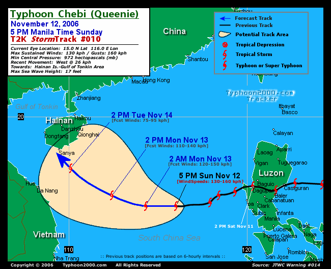
RECENT T2K TRACKING CHART:
________________________
RECENT MTSAT-1R SATELLITE IMAGE:

> Image source: Digital-Typhoon.org (Nat'l. Institute of Informatics) (http://www.digital-typhoon.org )
__________________________________________________________________________________________
NOTES:
> Image source: Digital-Typhoon.
^ - JTWC commentary remarks (for Meteorologists) from their
latest warning.
latest warning.
* - Based on PAGASA's Philippine Storm Warning Signals,
# 4 being the highest. Red bold letters indicate new
areas being hoisted. For more explanations on these
signals, visit: http://www.typhoon2000.ph/signals.htm
** - Based on the Tropical Cyclone's Wave Height near
its center.
__________________________________________________________________________________________
>> To know the meteorological terminologies and acronyms
used on this update visit the ff:
http://typhoon2000.ph/tcterm.htm
http://www.nhc.noaa.gov/aboutgloss.shtml
http://www.srh.noaa.gov/oun/severewx/glossary.php
http://www.srh.weather.gov/fwd/glossarynation.html
http://www.nhc.noaa.gov/acronyms.shtml
__________________________________________________________________________________________
:: Typhoon2000.com (T2K) Mobile >> Powered by: Synermaxx
Receive the latest storm updates directly to your mobile phones! To know more:
Send T2K HELP to: 2800 (GLOBE & TM) | 216 (SMART & TNT) | 2288 (SUN)
Note: Globe & Smart charges P2.50 per message, while Sun at P2.00.
__________________________________________________________________________________________
For the complete details on TS CHEBI (QUEENIE)...go visit
our website @:
> http://www.typhoon2000.com
> http://www.maybagyo.com
# 4 being the highest. Red bold letters indicate new
areas being hoisted. For more explanations on these
signals, visit: http://www.typhoon2
** - Based on the Tropical Cyclone's Wave Height near
its center.
____________
>> To know the meteorological terminologies and acronyms
used on this update visit the ff:
http://typhoon2000.
http://www.nhc.
http://www.srh.
http://www.srh.
http://www.nhc.
____________
:: Typhoon2000.
Receive the latest storm updates directly to your mobile phones! To know more:
Send T2K HELP to: 2800 (GLOBE & TM) | 216 (SMART & TNT) | 2288 (SUN)
Note: Globe & Smart charges P2.50 per message, while Sun at P2.00.
For the complete details on TS CHEBI (QUEENIE)...
our website @:
> http://www.typhoon2
> http://www.maybagyo
Change settings via the Web (Yahoo! ID required)
Change settings via email: Switch delivery to Daily Digest | Switch format to Traditional
Visit Your Group | Yahoo! Groups Terms of Use | Unsubscribe
SPONSORED LINKS
.
__,_._,___

No comments:
Post a Comment