Typhoon2000 STORM UPDATE #012
Name: TYPHOON UTOR [SENIANG/25W/0622]
Issued: 7:00 AM MANILA TIME (23:00 GMT) WED 13 DECEMBER 2006
Next Update: 7:00 PM (11:00 GMT) WED 13 DECEMBER 2006
Source: JTWC TROPICAL CYCLONE WARNING #024
Next Update: 7:00 PM (11:00 GMT) WED 13 DECEMBER 2006
Source: JTWC TROPICAL CYCLONE WARNING #024
_______________________________________________________________________
TYPHOON UTOR (SENIANG) HAS SHRUNKED AS IT MAINTAINED ITS
POWER WHILE MOVING CLOSER TO HAINAN ISLAND.
...All interests in the Vietnam and Hainan Island should
closely monitor the progress of Typhoon UTOR.
POWER WHILE MOVING CLOSER TO HAINAN ISLAND.
...All interests in the Vietnam and Hainan Island should
closely monitor the progress of Typhoon UTOR.
+ FORECAST OUTLOOK: UTOR is expected to continue moving
NW'ly across the South China Sea amd weaken...shall be
downgraded to a Tropical Storm in 24 hours and dissipate
near the Southern Coast of Hainan while drifting SW'ly.
Cool dry air intrusion, poor outflow support and strong
upper level winds (Wind Shear) are the reasons why this
system shall weaken in 96 hours.
+ EFFECTS: UTOR's circulation has shrunked during the
past 12 hours as it remains over the South China Sea
and not affecting any islands.
+ CURRENT MONSOON INTENSITY: Light to moderate Northeast
Monsoon enhanced by UTOR (SENIANG) will continue to bring
cloudy skies with occasional rains and 30-km/hr NE winds
across Taiwan, Ryukyu Islands, Hainan Is., and Southern
China including Hong Kong.
Important Note: Please keep in mind that the above forecast
outlook, effects & current monsoon intensity, and tropical
cyclone watch changes every 06 to 12 hours!
____________
TIME/DATE: 5:00 AM MANILA TIME (21:00 GMT) 13 DECEMBER
LOCATION OF EYE: LATITUDE 16.2º N...LONGITUDE 112.7º E
DISTANCE 1: 405 KM (218 NM) SE OF SANYA, HAINAN IS.
DISTANCE 2: 405 KM (218 NM) SSE OF QIONGHAI, HAINAN IS.
DISTANCE 3: 480 KM (260 NM) EAST OF DA NANG, VIETNAM
PEAK WIND GUSTS: 205 KM/HR (110 KTS)
SAFFIR-SIMPSON SCALE: CATEGORY TWO (2)
MINIMUM CENTRAL PRESSURE (est.): 954 MILLIBARS (hPa)
RECENT MOVEMENT: NW @ 20 KM/HR (11 KTS)
GENERAL DIRECTION: HAINAN ISLAND
STORM'S SIZE (IN DIAMETER): 705 KM (380 NM)/LARGE
MAX WAVE HEIGHT**: 34 FEET (10.3 METERS)
VIEW TRACKING MAP: 2 AM PST WED DECEMBER 13
TSR WIND PROBABILITIES: CURRENT TO 96 HRS LEAD
PHILIPPINE STORM SIGNALS*: N/A.
12, 24 & 48 HR. FORECAST:
2 PM (06 GMT) 13 DEC: 16.8N 111.9E / 150-185 KPH / NW @ 07 KPH
2 AM (18 GMT) 14 DEC: 17.3N 111.3E / 130-160 KPH / NNW @ 04 KPH
2 AM (18 GMT) 15 DEC: 17.9N 110.9E / 75-95 KPH / WEST @ 00 KPH
12, 24 & 48 HR. FORECAST:
2 PM (06 GMT) 13 DEC: 16.8N 111.9E / 150-185 KPH / NW @ 07 KPH
2 AM (18 GMT) 14 DEC: 17.3N 111.3E / 130-160 KPH / NNW @ 04 KPH
2 AM (18 GMT) 15 DEC: 17.9N 110.9E / 75-95 KPH / WEST @ 00 KPH
REMARKS: 2 AM (18 GMT) 13 DECEMBER POSITION: 16.0N 113.0E.
^TY UTOR WILL CONTINUE TRACKING WEST-NORTHWESTWARD ALONG THE
SOUTHWESTERN PERIPHERY OF THE MID-LEVEL SUBTROPICAL (STR) RIDGE
ANCHORED TO THE NORTHWEST OF GUAM. A SHORTWAVE TROUGH CURRENTLY
OVER CENTRAL CHINA WILL ENHANCE A WEAKNESS IN THE RIDGE TO THE
NORTH OF THE SYSTEM PRIOR TO 24 HRS. TY UTOR WILL TRACK NORTH-
WEST TOWARD THIS WEAKNESS AND BEGIN TO SLOW SIGNIFICANTLY AFTER
24 HOURS AS IT APPROACHES THE RIDGE AXIS AND THE STEERING ENVI-
RONMENT BECOMES WEAKER. THE SYSTEM WILL SLOW TO 01-02 KNOTS BY
48 HRS AND WILL REMAIN QUASISTATIONARY THROUGH 72 HRS AS THE
STEERING ENVIRONMENT BETWEEN THE STR TO THE EAST AND THE STR
ANCHORED OVER THE WESTERN BAY OF BENGAL CONTINUES TO BE WEAK
...(more info)
>> UTOR {pronounced: oo-TORE}, meaning: Marshallese word
for "squall line". Name contributed by: U.S.A.
____________
_______________________________________________________________________
RECENT T2K TRACKING CHART:
________________________
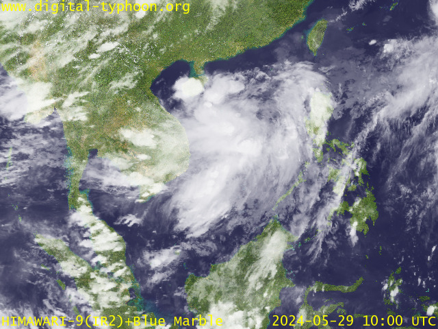
RECENT MTSAT-1R SATELLITE IMAGE:

> Image source: Digital-Typhoon.org (Nat'l. Institute of Informatics) (http://www.digital-typhoon.org )
__________________________________________________________________________________________
NOTES:

> Image source: Digital-Typhoon.
^ - JTWC commentary remarks (for Meteorologists) from their
latest warning.
latest warning.
* - Based on PAGASA's Philippine Storm Warning Signals,
# 4 being the highest. Red letters indicate new areas
being hoisted. For more explanations on these signals,
visit: http://www.typhoon2000.ph/signals.htm
** - Based on the Tropical Cyclone's Wave Height near
its center.
__________________________________________________________________________________________
>> To know the meteorological terminologies and acronyms
used on this update visit the ff:
http://typhoon2000.ph/tcterm.htm
http://www.nhc.noaa.gov/aboutgloss.shtml
http://www.srh.noaa.gov/oun/severewx/glossary.php
http://www.srh.weather.gov/fwd/glossarynation.html
http://www.nhc.noaa.gov/acronyms.shtml
__________________________________________________________________________________________
:: Typhoon2000.com (T2K) Mobile >> Powered by: Synermaxx
Receive the latest storm updates directly to your mobile phones! To know more:
Send T2K HELP to: 2800 (GLOBE & TM) | 216 (SMART & TNT) | 2288 (SUN)
Note: Globe & Smart charges P2.50 per message, while Sun at P2.00.
__________________________________________________________________________________________
For the complete details on TY UTOR (SENIANG)...go visit
our website @:
> http://www.typhoon2000.com
> http://www.maybagyo.com
# 4 being the highest. Red letters indicate new areas
being hoisted. For more explanations on these signals,
visit: http://www.typhoon2
** - Based on the Tropical Cyclone's Wave Height near
its center.
____________
>> To know the meteorological terminologies and acronyms
used on this update visit the ff:
http://typhoon2000.
http://www.nhc.
http://www.srh.
http://www.srh.
http://www.nhc.
____________
:: Typhoon2000.
Receive the latest storm updates directly to your mobile phones! To know more:
Send T2K HELP to: 2800 (GLOBE & TM) | 216 (SMART & TNT) | 2288 (SUN)
Note: Globe & Smart charges P2.50 per message, while Sun at P2.00.
For the complete details on TY UTOR (SENIANG)...
our website @:
> http://www.typhoon2
> http://www.maybagyo
Change settings via the Web (Yahoo! ID required)
Change settings via email: Switch delivery to Daily Digest | Switch format to Traditional
Visit Your Group | Yahoo! Groups Terms of Use | Unsubscribe
SPONSORED LINKS
.
__,_._,___
No comments:
Post a Comment