Typhoon2000 STORM UPDATE #001
Name: TROPICAL DEPRESSION 23W [NONAME]
Issued: 7:00 AM MANILA TIME (23:00 GMT) MON 19 NOVEMBER 2007
Next Update: 1:00 PM (05:00 GMT) MON 19 NOVEMBER
Source: JTWC TROPICAL CYCLONE WARNING NUMBER 001
Note: Kindly refer to your country's official warnings or bulletins. This update is for additional information purposes only.
Next Update: 1:00 PM (05:00 GMT) MON 19 NOVEMBER
Source: JTWC TROPICAL CYCLONE WARNING NUMBER 001
Note: Kindly refer to your country's official warnings or bulletins. This update is for additional information purposes only.
_____________________________________________________________________________
THE STRONG TROPICAL DISTURBANCE (LPA) NEAR THE COAST OF SURIGAO DEL SUR HAS
RAPIDLY DEVELOPED INTO TROPICAL DEPRESSION
23W (NONAME)...HEADING TOWARDSRAPIDLY DEVELOPED INTO TROPICAL DEPRESSION
SOUTHERN LEYTE-CEBU AREA. RESIDENTS OF THE VISAYAS MUST TAKE ALL PRE-
CAUTIONARY MEASURES ON THIS RAPIDLY INTENSIFYING SYSTEM AND MUST BE
ALERTED TODAY.
+ FORECAST OUTLOOK: 23W is expected to turn WNW in response to a building
+ FORECAST OUTLOOK: 23W is expected to turn WNW in response to a building
High Pressure over Hainan and extends towards Luzon Strait. It is likely
to reach Tropical Storm status later today and cross the Island of Siargao
before noon today and shall be over the Southern part of Leyte tonight.
The core of 23W is forecast to cross Visayas tonight until tomorrow eve-
ning, passing over the provinces of Cebu (5am Nov 20), Negros (7-9am Nov
20)..passing over the cities of Bacolod and Iloilo including Guimaras
(11am-2pm Nov 20), and shall be off Sulu Sea early Wednesday morning (Nov
21). This potential storm shall be over the South China Sea early Thursday
morning (Nov 22) after passing over the Northern tip of Palawan Wednesday
morning.
+ EFFECTS: 23W's large circulation is now affecting and covering the whole
+ EFFECTS: 23W's large circulation is now affecting and covering the whole
areas of the Visayas and Mindanao...bringing moderate to heavy rains with
winds not exceeding 60 km/hr today..becoming more intense along Siargao,
Surigao del Norte, Southern Samar, Southern Leyte and Bohol. Meanwhile,
the Bicol Region is under the outer rainbands of this disturbance accom-
panied with the NE Monsoon rains. People living around the slopes of Mayon
Volcano in Albay & of Bulusan Volcano in Sorsogon - especially along the
areas where possible LAHAR FLOWS (mixture of volcanic mud and water) are
located - must stay alert as moderate to heavy rains w/ some strong winds
associated by this disturbance are likely to prevail today until tomorrow.
+ CURRENT MONSOON INTENSITY: Strong Northeast (NE) Monsoon enhanced by
+ CURRENT MONSOON INTENSITY: Strong Northeast (NE) Monsoon enhanced by
23W will continue to bring cloudy skies with intermittent rains & strong
NE'ly winds of 30 km/hr or higher across Northern and Eastern Philippines.
Landslides, mudflows (lahars) and flooding is likely to occur along steep
mountain/volcano slopes, river banks, low-lying & flood-prone areas of the
affected areas, while big sea waves or surges generated by this monsoon can
affect the coastal and beach-front areas of Eastern Philippines.
Important Note: Please keep in mind that the above forecast outlook,
effects & current monsoon intensity, and tropical cyclone watch changes
every 06 to 12 hours!
_____________________________________________________________________________
TIME/DATE: 5:00 AM MANILA TIME (21:00 GMT) 19 NOVEMBER
LOCATION OF CENTER: LATITUDE 9.4º N...LONGITUDE 126.8º E
DISTANCE 1: 90 KM (48 NM) ESE OF SIARGAO ISLAND, PH
effects & current monsoon intensity, and tropical cyclone watch changes
every 06 to 12 hours!
____________
LOCATION OF CENTER: LATITUDE 9.4º N...LONGITUDE 126.8º E
DISTANCE 1: 90 KM (48 NM) ESE OF SIARGAO ISLAND, PH
DISTANCE 2: 150 KM (80 NM) ESE OF SURIGAO CITY, PH
DISTANCE 3: 335 KM (182 NM) ESE OF CEBU CITY, PH
DISTANCE 4: 290 KM (157 NM) SE OF TACLOBAN CITY, PH
DISTANCE 5: 450 KM (242 NM) ESE OF BACOLOD CITY, PH
PEAK WIND GUSTS: 75 KM/HR (40 KTS)
SAFFIR-SIMPSON SCALE: N/A
MINIMUM CENTRAL PRESSURE (est.): 1000 MILLIBARS (hPa)
RECENT MOVEMENT: NW @ 13 KM/HR (07 KTS)
GENERAL DIRECTION: SOUTHERN LEYTE-CEBU AREA
STORM'S SIZE (IN DIAMETER): 500 KM (270 NM)/AVERAGE
MAX WAVE HEIGHT**: 10 FEET (3.0 METERS)
VIEW TRACKING MAP: 2 AM MANILA TIME MON NOVEMBER 19
TSR WIND PROBABILITIES: CURRENT TO 72 HRS LEAD
PHILIPPINE STORM SIGNALS*: none
12, 24 & 48 HR. FORECAST:
2 PM (06 GMT) 19 NOVEMBER: 9.9N 125.8E / 75-95 KPH / WNW @ 15 KPH
2 AM (18 GMT) 20 NOVEMBER: 10.4N 124.3E / 85-100 KPH / W @ 15 KPH
2 AM (18 GMT) 21 NOVEMBER: 11.0N 121.0E / 95-120 KPH / W @ 17 KPH
REMARKS: 2 AM (18 GMT) 19 NOVEMBER POSITION: 9.2N 127.1E.
^ANIMATED INFRARED SATELLITE IMAGERY INDICATES A RAPIDLY DEVELOPING
SYSTEM WITH A LARGE SYMMETRIC CDO FEATURE OF 240 NM DIAMETER AND
DEVELOPING CONVECTIVE BANDING OVER THE NORTHERN SEMICIRCLE. AN 181718Z
AMSU IMAGE DEPICTED DEEP CONVECTIVE BANDING WRAPPING FROM THE NORTH
INTO THE SOUTHEASTERN QUADRANT WITH A WELL-DEFINED LOW-LEVEL CIRC-
ULATION CENTER (LLCC). THE CURRENT INTENSITY IS SLIGHTLY LOWER THAN
THE DVORAK INTENSITY ESTIMATES OF 35 (PGTW) TO 45 KNOTS (KNES) AND
IS BASED PRIMARILY ON RECENT QUIKSCAT, ASCAT AND SURFACE OBSERVATIONS
WHICH INDICATE SLP NEAR 1002 MB AND WINDS 25-30 KNOTS. THE CURRENT
POSITION IS BASED ON A TIGHT CLUSTER OF FIXES AND RECENT MICROWAVE
IMAGERY. TD 23W IS FORECAST TO TRACK WESTWARD UNDER THE STEERING
INFLUENCE OF A DEEP SUBTROPICAL RIDGE WHICH EXTENDS FROM A HIGH
NEAR HAINAN ISLAND EASTWARD INTO THE LUZON STRAIGHT. AVAILABLE
DYNAMIC AIDS ARE SPARSE BUT ARE IN GOOD AGREEMENT WITH THE TRACK.
ANIMATED WATER VAPOR IMAGERY DEPICTS IMPROVING POLEWARD OUTFLOW
ENHANCED BY A MIDLATITUDE SHORTWAVE OVER EASTERN CHINA. EQUATORWARD
OUTFLOW HAS ALSO IMPROVED. THE ENVIRONMENT HAS IMPROVED AND IS
FAVORABLE FOR FURTHER DEVELOPMENT. BOTH SST AND OCEAN HEAT CONTENT
VALUES ARE HIGH WITH A VERY MOIST ENVIRONMENT AS EVIDENT ON THE
LATEST TOTAL PRECIPITABLE WATER PRODUCT FROM NRL. HOWEVER, TD 23W
IS EXPECTED TO INTENSIFY SLOWLY AT 5 TO 15 KNOTS PER DAY DUE MAINLY
TO LAND INTERACTION AS THE SYSTEM CROSSES THE CENTRAL PHILIPPINES.
IT IS POSSIBLE THAT THE SYSTEM MAY INTENSIFY MORE RAPIDLY SINCE
IT SHOULD TRACK ACROSS THE INLAND SEAS WHICH HISTORICALLY CAN
PRODUCE RAPID INTENSIFICATION...(more)
_____________________________________________________________________________
REMARKS: 2 AM (18 GMT) 19 NOVEMBER POSITION: 9.2N 127.1E.
^ANIMATED INFRARED SATELLITE IMAGERY INDICATES A RAPIDLY DEVELOPING
SYSTEM WITH A LARGE SYMMETRIC CDO FEATURE OF 240 NM DIAMETER AND
DEVELOPING CONVECTIVE BANDING OVER THE NORTHERN SEMICIRCLE. AN 181718Z
AMSU IMAGE DEPICTED DEEP CONVECTIVE BANDING WRAPPING FROM THE NORTH
INTO THE SOUTHEASTERN QUADRANT WITH A WELL-DEFINED LOW-LEVEL CIRC-
ULATION CENTER (LLCC). THE CURRENT INTENSITY IS SLIGHTLY LOWER THAN
THE DVORAK INTENSITY ESTIMATES OF 35 (PGTW) TO 45 KNOTS (KNES) AND
IS BASED PRIMARILY ON RECENT QUIKSCAT, ASCAT AND SURFACE OBSERVATIONS
WHICH INDICATE SLP NEAR 1002 MB AND WINDS 25-30 KNOTS. THE CURRENT
POSITION IS BASED ON A TIGHT CLUSTER OF FIXES AND RECENT MICROWAVE
IMAGERY. TD 23W IS FORECAST TO TRACK WESTWARD UNDER THE STEERING
INFLUENCE OF A DEEP SUBTROPICAL RIDGE WHICH EXTENDS FROM A HIGH
NEAR HAINAN ISLAND EASTWARD INTO THE LUZON STRAIGHT. AVAILABLE
DYNAMIC AIDS ARE SPARSE BUT ARE IN GOOD AGREEMENT WITH THE TRACK.
ANIMATED WATER VAPOR IMAGERY DEPICTS IMPROVING POLEWARD OUTFLOW
ENHANCED BY A MIDLATITUDE SHORTWAVE OVER EASTERN CHINA. EQUATORWARD
OUTFLOW HAS ALSO IMPROVED. THE ENVIRONMENT HAS IMPROVED AND IS
FAVORABLE FOR FURTHER DEVELOPMENT. BOTH SST AND OCEAN HEAT CONTENT
VALUES ARE HIGH WITH A VERY MOIST ENVIRONMENT AS EVIDENT ON THE
LATEST TOTAL PRECIPITABLE WATER PRODUCT FROM NRL. HOWEVER, TD 23W
IS EXPECTED TO INTENSIFY SLOWLY AT 5 TO 15 KNOTS PER DAY DUE MAINLY
TO LAND INTERACTION AS THE SYSTEM CROSSES THE CENTRAL PHILIPPINES.
IT IS POSSIBLE THAT THE SYSTEM MAY INTENSIFY MORE RAPIDLY SINCE
IT SHOULD TRACK ACROSS THE INLAND SEAS WHICH HISTORICALLY CAN
PRODUCE RAPID INTENSIFICATION...(more)
____________
_____________________________________________________________________________
RECENT JTWC TRACKING CHART:
RECENT JTWC TRACKING CHART:

________________________
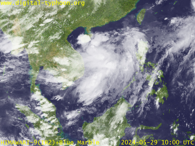
RECENT MTSAT-1R SATELLITE IMAGE:

> Image source: Digital-Typhoon.org (Nat'l. Institute of Informatics) (http://www.digital-typhoon.org )
__________________________________________________________________________________________
NOTES:

> Image source: Digital-Typhoon.
^ - JTWC commentary remarks (for Meteorologists) from their
latest warning.
latest warning.
* - Based on PAGASA's Philippine Storm Warning Signals,
# 4 being the highest. Red letters indicate new areas
being hoisted. For more explanations on these signals,
visit: http://www.typhoon2000.ph/signals.htm
** - Based on the Tropical Cyclone's Wave Height near
its center.
__________________________________________________________________________________________
>> To know the meteorological terminologies and acronyms
used on this update visit the ff:
http://typhoon2000.ph/tcterm.htm
http://www.nhc.noaa.gov/aboutgloss.shtml
http://www.srh.noaa.gov/oun/severewx/glossary.php
http://www.srh.weather.gov/fwd/glossarynation.html
http://www.nhc.noaa.gov/acronyms.shtml
__________________________________________________________________________________________
:: Typhoon2000.com (T2K) Mobile >> Powered by: Synermaxx
Receive the latest storm updates directly to your mobile phones! To know more:
Send T2K HELP to: 2800 (GLOBE & TM) | 216 (SMART & TNT) | 2288 (SUN)
Note: Globe & Smart charges P2.50 per message, while Sun at P2.00.
__________________________________________________________________________________________
For the complete details on TD 23W (NONAME)...go visit
our website @:
> http://www.typhoon2000.com
> http://www.maybagyo.com
# 4 being the highest. Red letters indicate new areas
being hoisted. For more explanations on these signals,
visit: http://www.typhoon2
** - Based on the Tropical Cyclone's Wave Height near
its center.
____________
>> To know the meteorological terminologies and acronyms
used on this update visit the ff:
http://typhoon2000.
http://www.nhc.
http://www.srh.
http://www.srh.
http://www.nhc.
____________
:: Typhoon2000.
Receive the latest storm updates directly to your mobile phones! To know more:
Send T2K HELP to: 2800 (GLOBE & TM) | 216 (SMART & TNT) | 2288 (SUN)
Note: Globe & Smart charges P2.50 per message, while Sun at P2.00.
For the complete details on TD 23W (NONAME)...go visit
our website @:
> http://www.typhoon2
> http://www.maybagyo
Change settings via the Web (Yahoo! ID required)
Change settings via email: Switch delivery to Daily Digest | Switch format to Traditional
Visit Your Group | Yahoo! Groups Terms of Use | Unsubscribe
.
__,_._,___
No comments:
Post a Comment