Typhoon2000 STORM UPDATE #004
Name: TROPICAL STORM 23W [LANDO]
Issued: 7:00 AM MANILA TIME (23:00 GMT) TUE 20 NOVEMBER 2007
Next Update: 7:00 PM (11:00 GMT) TUE 20 NOVEMBER
Source: JTWC TROPICAL CYCLONE WARNING NUMBER 005
Note: Kindly refer to your country's official warnings or bulletins. This update is for additional information purposes only.
Next Update: 7:00 PM (11:00 GMT) TUE 20 NOVEMBER
Source: JTWC TROPICAL CYCLONE WARNING NUMBER 005
Note: Kindly refer to your country's official warnings or bulletins. This update is for additional information purposes only.
_____________________________________________________________________________
23W (LANDO) GREW INTO A TROPICAL STORM UPON CROSSING THE ISLANDS OF
CEBU, NEGROS AND GUIMARAS...NOW OFF SULU SEA. DISPLACED OUTER RAIN-
BANDS OF THE STORM CURRENTLY AFFECTING SAMAR, LEYTE AND BICOL REGION.
+ FORECAST OUTLOOK: 23W (LANDO) is expected to continue tracking West-
+ FORECAST OUTLOOK: 23W (LANDO) is expected to continue tracking West-
ward, passing over Northern Palawan around sunset today. It shall be
moving into the South China Sea tonight. The 24-hr to 5-day Forecast
shows 23W continuing traversing the southern portion of the South
China Sea and shall exit the Philippine Area of Responsibility tomorrow
evening. It shall become a well-developed 130 km/hr, Category 1 Typhoon
upon approaching the coast of Southern Vietnam.
+ EFFECTS: 23W's large rain circulation continues to affect and cover
+ EFFECTS: 23W's large rain circulation continues to affect and cover
the whole area of the Visayas & Southern Luzon...bringing moderate to
heavy rains with winds not exceeding 85 km/hr today..becoming more
intense along Cuyo Is., Sulu Sea & Northern Palawan. People living
around the slopes of Mayon Volcano in Albay & of Bulusan Volcano in
Sorsogon - especially along the areas where possible LAHAR FLOWS
(mixture of volcanic mud and water) are located - must stay alert as
moderate to heavy rains w/ some strong winds associated by this dis-
turbance are likely to prevail today.
+ CURRENT MONSOON INTENSITY: Strong Northeast (NE) Monsoon enhanced by
+ CURRENT MONSOON INTENSITY: Strong Northeast (NE) Monsoon enhanced by
Tropical Storm 23W (LANDO) will continue to bring cloudy skies with
intermittent rainshowers & strong NE'ly winds of 30 km/hr or higher
across Northern and Eastern Philippines. Landslides, mudflows (lahars)
and flooding is likely to occur along steep mountain/volcano slopes,
river banks, low-lying & flood-prone areas of the affected areas,
while big sea waves or surges generated by this monsoon can affect
the coastal and beach-front areas of Eastern Philippines.
+ TROPICAL CYCLONE WATCH: Tropical Disturbance 93W (LPA/1007 MB) West
+ TROPICAL CYCLONE WATCH: Tropical Disturbance 93W (LPA/1007 MB) West
of Guam has become active and is strengthening...likely to become a
Tropical Cyclone within the next 06 to 12 hours. The potential system
is now located some 1,370 km. East of Borongan, Eastern Samar (11.9N
138.0E). Moving West slowly...with wind speed of 40 km/hr near the
potential center. **Initial Impact Forecast (as of 2 AM Nov 20) shows
the potential system becoming a strong Tropical Cyclone and (1)
passing over Northern Bicol on its way to Northern Quezon or (2)
passing over Samar on its way to Northern Visayas sometime Nov 23-25
(Fri-Sun). Communities along these areas must be on alert and must
initiate advance precautionary plans on this upcoming system. Watch
out for more updates soon. Click HERE to view the latest satellite
image on this new developing system.
image on this new developing system.
Important Note: Please keep in mind that the above forecast outlook,
effects & current monsoon intensity, and tropical cyclone watch changes
every 06 to 12 hours!
_____________________________________________________________________________
TIME/DATE: 5:00 AM MANILA TIME (21:00 GMT) 20 NOVEMBER
LOCATION OF CENTER: LATITUDE 10.4º N...LONGITUDE 121.4º E
DISTANCE 1: 70 KM (38 NM) SE OF CUYO IS., PH
effects & current monsoon intensity, and tropical cyclone watch changes
every 06 to 12 hours!
____________
LOCATION OF CENTER: LATITUDE 10.4º N...LONGITUDE 121.4º E
DISTANCE 1: 70 KM (38 NM) SE OF CUYO IS., PH
DISTANCE 2: 135 KM (73 NM) WSW OF ILOILO CITY, PH
DISTANCE 3: 165 KM (90 NM) WSW OF BACOLOD CITY, PH
DISTANCE 4: 305 KM (165 NM) ENE OF PUERTO PRINCESA CITY, PH
DISTANCE 5: 175 KM (95 NM) SSE OF BORACAY ISLAND RESORT, PH
PEAK WIND GUSTS: 85 KM/HR (45 KTS)
SAFFIR-SIMPSON SCALE: N/A
MINIMUM CENTRAL PRESSURE (est.): 996 MILLIBARS (hPa)
RECENT MOVEMENT: WEST @ 24 KM/HR (13 KTS)
GENERAL DIRECTION: NORTHERN PALAWAN
STORM'S SIZE (IN DIAMETER): 500 KM (270 NM)/AVERAGE
MAX WAVE HEIGHT**: 11 FEET (3.3 METERS)
VIEW T2K TRACKING MAP: 5 AM MANILA TIME TUE NOVEMBER 20
TSR WIND PROBABILITIES: CURRENT TO 120 HRS LEAD
PHILIPPINE STORM SIGNALS*:
#02 - ILOILO CITY, ANTIQUE, GUIMARAS IS. & CUYO IS.
#01 - NEGROS OCCIDENTAL, AKLAN, CAPIZ, NORTHERN PALAWAN AND
CALAMIAN GROUP OF ISLANDS.
12, 24 & 48 HR. FORECAST:
2 PM (06 GMT) 20 NOVEMBER: 10.3N 119.2E / 75-95 KPH / W @ 33 KPH
2 AM (18 GMT) 21 NOVEMBER: 9.9N 115.5E / 85-100 KPH / W @ 24 KPH
#01 - NEGROS OCCIDENTAL, AKLAN, CAPIZ, NORTHERN PALAWAN AND
CALAMIAN GROUP OF ISLANDS.
12, 24 & 48 HR. FORECAST:
2 PM (06 GMT) 20 NOVEMBER: 10.3N 119.2E / 75-95 KPH / W @ 33 KPH
2 AM (18 GMT) 21 NOVEMBER: 9.9N 115.5E / 85-100 KPH / W @ 24 KPH
2 AM (18 GMT) 22 NOVEMBER: 9.5N 110.8E / 100-130 KPH / W @ 13 KPH
REMARKS: 2 AM (18 GMT) 20 NOVEMBER POSITION: 10.4N 122.2E.
^TROPICAL STORM (TS) 23W HAS MAINTAINED INTENSITY OVER PAST 12 HOURS
UNDER THE INFLUENCES OF FAVORABLE UPPER LEVEL OUTFLOW AND LOW TO
MODERATE VERTICAL WIND SHEAR AND UNFAVORABLE LAND INTERACTION. A
LARGE FLARE OF DEEP CONVECTION THAT ACCOMPANIED THE LOW LEVEL
CIRCULATION CENTER 12 HOURS AGO HAS LARGELY DISSIPATED, AND
CONVECTIVE ACTIVITY NOWS REMAINS LARGELY CONFINED TO THE NORTHERN
AND WESTERN PERIPHERIES OF THE LOW LEVEL CIRCULATION...(more)
_____________________________________________________________________________
PAGASA CURRENT POSITION, MOVEMENT AND INTENSITY (10-min. ave.):
REMARKS: 2 AM (18 GMT) 20 NOVEMBER POSITION: 10.4N 122.2E.
^TROPICAL STORM (TS) 23W HAS MAINTAINED INTENSITY OVER PAST 12 HOURS
UNDER THE INFLUENCES OF FAVORABLE UPPER LEVEL OUTFLOW AND LOW TO
MODERATE VERTICAL WIND SHEAR AND UNFAVORABLE LAND INTERACTION. A
LARGE FLARE OF DEEP CONVECTION THAT ACCOMPANIED THE LOW LEVEL
CIRCULATION CENTER 12 HOURS AGO HAS LARGELY DISSIPATED, AND
CONVECTIVE ACTIVITY NOWS REMAINS LARGELY CONFINED TO THE NORTHERN
AND WESTERN PERIPHERIES OF THE LOW LEVEL CIRCULATION...(more)
____________
PAGASA CURRENT POSITION, MOVEMENT AND INTENSITY (10-min. ave.):
> 4 AM (20 GMT) 20 NOVEMBER: 10.5N 121.6E / W @ 19 KPH / 65 kph
:: For the complete PAGASA bulletin, kindly visit their website at:
http://www.pagasa.dost.gov.ph/wb/tcupdate.shtml
:: For the complete PAGASA bulletin, kindly visit their website at:
http://www.pagasa.
_____________________________________________________________________________
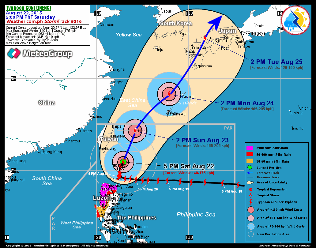
RECENT T2K TRACKING CHART:
RECENT T2K TRACKING CHART:

________________________
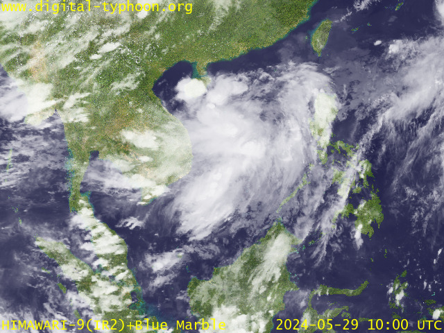
RECENT MTSAT-1R SATELLITE IMAGE:

> Image source: Digital-Typhoon.org (Nat'l. Institute of Informatics) (http://www.digital-typhoon.org )
__________________________________________________________________________________________
NOTES:

> Image source: Digital-Typhoon.
^ - JTWC commentary remarks (for Meteorologists) from their
latest warning.
latest warning.
* - Based on PAGASA's Philippine Storm Warning Signals,
# 4 being the highest. Red letters indicate new areas
being hoisted. For more explanations on these signals,
visit: http://www.typhoon2000.ph/signals.htm
** - Based on the Tropical Cyclone's Wave Height near
its center.
__________________________________________________________________________________________
>> To know the meteorological terminologies and acronyms
used on this update visit the ff:
http://typhoon2000.ph/tcterm.htm
http://www.nhc.noaa.gov/aboutgloss.shtml
http://www.srh.noaa.gov/oun/severewx/glossary.php
http://www.srh.weather.gov/fwd/glossarynation.html
http://www.nhc.noaa.gov/acronyms.shtml
__________________________________________________________________________________________
:: Typhoon2000.com (T2K) Mobile >> Powered by: Synermaxx
Receive the latest storm updates directly to your mobile phones! To know more:
Send T2K HELP to: 2800 (GLOBE & TM) | 216 (SMART & TNT) | 2288 (SUN)
Note: Globe & Smart charges P2.50 per message, while Sun at P2.00.
__________________________________________________________________________________________
For the complete details on TS 23W (LANDO)...go visit
our website @:
> http://www.typhoon2000.com
> http://www.maybagyo.com
# 4 being the highest. Red letters indicate new areas
being hoisted. For more explanations on these signals,
visit: http://www.typhoon2
** - Based on the Tropical Cyclone's Wave Height near
its center.
____________
>> To know the meteorological terminologies and acronyms
used on this update visit the ff:
http://typhoon2000.
http://www.nhc.
http://www.srh.
http://www.srh.
http://www.nhc.
____________
:: Typhoon2000.
Receive the latest storm updates directly to your mobile phones! To know more:
Send T2K HELP to: 2800 (GLOBE & TM) | 216 (SMART & TNT) | 2288 (SUN)
Note: Globe & Smart charges P2.50 per message, while Sun at P2.00.
For the complete details on TS 23W (LANDO)...go visit
our website @:
> http://www.typhoon2
> http://www.maybagyo
Change settings via the Web (Yahoo! ID required)
Change settings via email: Switch delivery to Daily Digest | Switch format to Traditional
Visit Your Group | Yahoo! Groups Terms of Use | Unsubscribe
.
__,_._,___
No comments:
Post a Comment