
Typhoon2000 STORM UPDATE #008
Name: TROPICAL STORM HAGIBIS [LANDO/23W/0724]
Issued: 10:00 AM MANILA TIME (02:00 GMT) TUE 27 NOVEMBER 2007
Source: JMA TROPICAL CYCLONE ADVISORY: 27/00UTC
Note: Kindly refer to your country's official warnings or bulletins. This update is for additional information purposes only.
Source: JMA TROPICAL CYCLONE ADVISORY: 27/00UTC
Note: Kindly refer to your country's official warnings or bulletins. This update is for additional information purposes only.
_____________________________________________________________________________
TROPICAL STORM HAGIBIS (LANDO) AFTER LINGERING OFF THE COAST OF SOUTH-
EASTERN VIETNAM FOR 3 TO 4 DAYS HAS TURNED BACK DUE TO THE BINARY IN-
TERACTION WITH TYPHOON MITAG AND A STRONG NEAR-EQUATORIAL HIGH PRESSURE
...NOW HEADING TOWARDS THE WESTERN PHILIPPINES. THREATENS MINDORO AND
BICOL PROVINCES.
+ FORECAST OUTLOOK: HAGIBIS is expected to continue accelerating ENE-ward
for the next 24 hours and shall make landfall over Mindoro this afternoon.
The storm may pass in between Romblon and Marinduque later tonight and
across Ragay Gulf early tomorrow morning. It shall make landfall over
Pasacao, Camarines Sur around 5-6 AM tomorrow, passing very close to
Pasacao, Camarines Sur around 5-6 AM tomorrow, passing very close to
Naga City around 7 AM. HAGIBIS is forecast to be over Lagonoy Gulf around
8 AM tomorrow, and move across the island of Catanduanes later (approx
9 AM) before exiting out into the Philippine Sea.
+ EFFECTS: HAGIBIS' circulation is now affecting Calamian & Mindoro, with
its center partially exposed - meaning the rain clouds of this system is
+ EFFECTS: HAGIBIS' circulation is now affecting Calamian & Mindoro, with
its center partially exposed - meaning the rain clouds of this system is
displaced away or west of the center. A new burst of convective rainclouds
has developed right of the center. This rainclouds may bring moderate to
heavy rains across the affected and forecasted area. People living around
the slopes of Mayon Volcano in Albay & of Bulusan Volcano in Sorsogon -
especially along the areas where possible LAHAR FLOWS (mixture of volcanic
mud and water) are located must stay alert as moderate to heavy rains
associated by this cloudiness are likely to prevail beginning late
this afternoon. Low-lying areas of Rinconada and Partido District of
Camarines Sur must seek higher grounds for possible flooding due to
the anticipated heavy rains brought about by this "balikbayan" storm.
Precautionary measures must be implemented now.
Important Note: Please keep in mind that the above forecast outlook,
effects & current monsoon intensity, and tropical cyclone watch changes
every 06 to 12 hours!
_____________________________________________________________________________
TIME/DATE: 8:00 AM MANILA TIME (00:00 GMT) 27 NOVEMBER
LOCATION OF CENTER: LATITUDE 12.0º N...LONGITUDE 119.0º E
DISTANCE 1: 130 KM (70 NM) WEST OF CORON, PALAWAN, PH
effects & current monsoon intensity, and tropical cyclone watch changes
every 06 to 12 hours!
____________
LOCATION OF CENTER: LATITUDE 12.0º N...LONGITUDE 119.0º E
DISTANCE 1: 130 KM (70 NM) WEST OF CORON, PALAWAN, PH
DISTANCE 2: 230 KM (125 NM) WSW OF SAN JOSE, OCC. MINDORO, PH
DISTANCE 3: 315 KM (170 NM) WEST OF BORACAY ISLAND RESORT, PH
DISTANCE 4: 490 KM (265 NM) WSW OF NAGA CITY, PH
DISTANCE 5: 530 KM (285 NM) WSW OF LEGAZPI CITY, PH
MAX WINDS [10-MIN AVG]: 85 KM/HR (45 KTS) NEAR THE CENTER
PEAK WIND GUSTS: 120 KM/HR (65 KTS)
SAFFIR-SIMPSON SCALE: N/A
MINIMUM CENTRAL PRESSURE (est.): 994 MILLIBARS (hPa)
RECENT MOVEMENT: ENE @ 24 KM/HR (13 KTS)
GENERAL DIRECTION: MINDORO-ROMBLON-MARINDUQUE-BICOL AREA
STORM'S SIZE (IN DIAMETER): 685 KM (370 NM)/AVERAGE
MAX WAVE HEIGHT**: 13 FEET (3.9 METERS)
VIEW T2K TRACKING MAP: 11 AM MANILA TIME TUE NOVEMBER 27
TSR WIND PROBABILITIES: CURRENT TO 96 HRS LEAD
PHILIPPINE STORM SIGNALS*:
#01 - ORIENTAL MINDORO, OCCIDENTAL MINDORO, LUBANG IS., ROMBLON,
DISTANCE 4: 490 KM (265 NM) WSW OF NAGA CITY, PH
DISTANCE 5: 530 KM (285 NM) WSW OF LEGAZPI CITY, PH
MAX WINDS [10-MIN AVG]: 85 KM/HR (45 KTS) NEAR THE CENTER
PEAK WIND GUSTS: 120 KM/HR (65 KTS)
SAFFIR-SIMPSON SCALE: N/A
MINIMUM CENTRAL PRESSURE (est.): 994 MILLIBARS (hPa)
RECENT MOVEMENT: ENE @ 24 KM/HR (13 KTS)
GENERAL DIRECTION: MINDORO-ROMBLON-
MAX WAVE HEIGHT**: 13 FEET (3.9 METERS)
VIEW T2K TRACKING MAP: 11 AM MANILA TIME TUE NOVEMBER 27
TSR WIND PROBABILITIES: CURRENT TO 96 HRS LEAD
PHILIPPINE STORM SIGNALS*:
#01 - ORIENTAL MINDORO, OCCIDENTAL MINDORO, LUBANG IS., ROMBLON,
MARINDUQUE, BATANGAS, LAGUNA, RIZAL, SOUTHERN QUEZON,
CAMARINES NORTE, CAMARINES SUR, ALBAY, BURIAS ISLAND,
CATANDUANES, PALAWAN AND CALAMIAN GROUP OF ISLANDS.
24 & 48 HR. FORECAST:
8 AM (00 GMT) 27 NOVEMBER: 13.7N 123.9E / 95-130 KPH / ENE @ 24 KPH
24 & 48 HR. FORECAST:
8 AM (00 GMT) 27 NOVEMBER: 13.7N 123.9E / 95-130 KPH / ENE @ 24 KPH
8 AM (00 GMT) 28 NOVEMBER: 15.9N 129.0E / 85-120 KPH / ENE @ 24 KPH
_____________________________________________________________________________
PAGASA CURRENT POSITION, MOVEMENT AND INTENSITY (10-min. ave.):
____________
PAGASA CURRENT POSITION, MOVEMENT AND INTENSITY (10-min. ave.):
> 10 AM (02 GMT) 27 NOVEMBER: 12.2N 119.0E / ENE @ 22 KPH / 55 kph
:: For the complete PAGASA bulletin, kindly visit their website at:
http://www.pagasa.dost.gov.ph/wb/tcupdate.shtml
:: For the complete PAGASA bulletin, kindly visit their website at:
http://www.pagasa.
_____________________________________________________________________________
RECENT T2K TRACKING CHART:
RECENT T2K TRACKING CHART:

________________________
RECENT MTSAT-1R SATELLITE IMAGE:
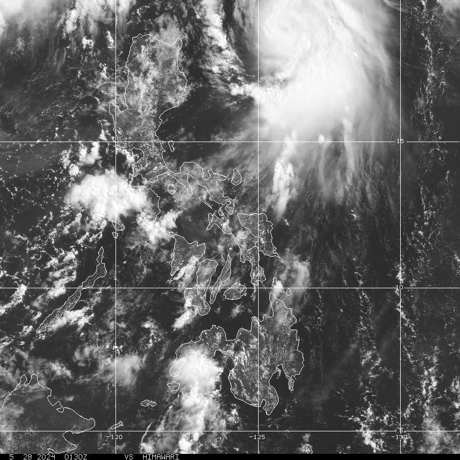
> Image source: Digital-Typhoon.org (Nat'l. Institute of Informatics) (http://www.digital-typhoon.org )
__________________________________________________________________________________________
NOTES:
> Image source: Digital-Typhoon.
^ - JTWC commentary remarks (for Meteorologists) from their
latest warning.
latest warning.
* - Based on PAGASA's Philippine Storm Warning Signals,
# 4 being the highest. Red letters indicate new areas
being hoisted. For more explanations on these signals,
visit: http://www.typhoon2000.ph/signals.htm
** - Based on the Tropical Cyclone's Wave Height near
its center.
__________________________________________________________________________________________
>> To know the meteorological terminologies and acronyms
used on this update visit the ff:
http://typhoon2000.ph/tcterm.htm
http://www.nhc.noaa.gov/aboutgloss.shtml
http://www.srh.noaa.gov/oun/severewx/glossary.php
http://www.srh.weather.gov/fwd/glossarynation.html
http://www.nhc.noaa.gov/acronyms.shtml
__________________________________________________________________________________________
:: Typhoon2000.com (T2K) Mobile >> Powered by: Synermaxx
Receive the latest storm updates directly to your mobile phones! To know more:
Send T2K HELP to: 2800 (GLOBE & TM) | 216 (SMART & TNT) | 2288 (SUN)
Note: Globe & Smart charges P2.50 per message, while Sun at P2.00.
__________________________________________________________________________________________
For the complete details on TS HAGIBIS (LANDO)...go visit
our website @:
> http://www.typhoon2000.com
> http://www.maybagyo.com
# 4 being the highest. Red letters indicate new areas
being hoisted. For more explanations on these signals,
visit: http://www.typhoon2
** - Based on the Tropical Cyclone's Wave Height near
its center.
____________
>> To know the meteorological terminologies and acronyms
used on this update visit the ff:
http://typhoon2000.
http://www.nhc.
http://www.srh.
http://www.srh.
http://www.nhc.
____________
:: Typhoon2000.
Receive the latest storm updates directly to your mobile phones! To know more:
Send T2K HELP to: 2800 (GLOBE & TM) | 216 (SMART & TNT) | 2288 (SUN)
Note: Globe & Smart charges P2.50 per message, while Sun at P2.00.
For the complete details on TS HAGIBIS (LANDO)...go visit
our website @:
> http://www.typhoon2
> http://www.maybagyo
Change settings via the Web (Yahoo! ID required)
Change settings via email: Switch delivery to Daily Digest | Switch format to Traditional
Visit Your Group | Yahoo! Groups Terms of Use | Unsubscribe
.
__,_._,___

No comments:
Post a Comment