Typhoon2000 STORM UPDATE #008
Name: TYPHOON PEIPAH [KABAYAN/21W/0721]
Issued: 7:00 AM MANILA TIME (23:00 GMT) WED 07 NOVEMBER 2007
Next Update: 7:00 PM (11:00 GMT) WED 07 NOVEMBER
Source: JTWC TROPICAL CYCLONE WARNING NUMBER 015
Note: Kindly refer to your country's official warnings or bulletins. This update is for additional information purposes only.
Next Update: 7:00 PM (11:00 GMT) WED 07 NOVEMBER
Source: JTWC TROPICAL CYCLONE WARNING NUMBER 015
Note: Kindly refer to your country's official warnings or bulletins. This update is for additional information purposes only.
_____________________________________________________________________________
TYPHOON PEIPAH (KABAYAN) LOSING STRENGTH AS IT BEGUN HEADING SOUTHWEST-
WARD...EXITS THE PHILIPPINE AREA OF RESPONSIBILITY (PAR).+ FORECAST OUTLOOK: PEIPAH is expected to track WSW for the next 12 to
24 hours and weaken. The 2 to 5-day forecast now showing PEIPAH weake-
ning more rapidly than expected due to increasing wind shear conditions
(upper lever winds) across the South China Sea. The system shall be
approaching the Eastern Coast of Southern Vietnam early Sunday morning,
Nov 11 as a dissipating Tropical Depression and shall make landfall in
the vicinity of Nha Trang, Vietnam. It shall dissipate near Ho Chi
Minh City on early Monday morning, Nov 12.
+ EFFECTS: PEIPAH's circulation remains compact in the middle of the
+ EFFECTS: PEIPAH's circulation remains compact in the middle of the
South China Sea. Extreme Eastern portion of its outer rainbands no
longer affecting Western Luzon. Coastal Storm Surge flooding of 3 to
5 feet above normal tide levels...along with large and dangerous ba-
ttering waves can be expected near and to the north of PEIPAH's pro-
jected path Minimal damage is possible on this type of storm surge.
Far-fetched storm surge is also possible along coastal areas of
Western Luzon.
+ TROPICAL CYCLONE WATCH: The Tropical Disturbance (LPA/98W/1004 MB)
+ TROPICAL CYCLONE WATCH: The Tropical Disturbance (LPA/98W/1004 MB)
over the Philippine Sea has dissipated and is no longer considered
suspect for possible TC development.
+ CURRENT MONSOON INTENSITY: Northeast (NE) Monsoon enhanced by TY
+ CURRENT MONSOON INTENSITY: Northeast (NE) Monsoon enhanced by TY
PEIPAH (KABAYAN) will continue to bring cloudy skies with intermi-
ttent rains & strong NE'ly winds of 30 km/hr or higher across Batanes
Group, Taiwan and the Coastal areas of Southern and Eastern China.
Landslides and flooding is likely to occur along steep mountain/volcano
slopes, river banks, low-lying & flood-prone areas of the affected
areas, while big sea waves or surges generated by this monsoon can
affect the coastal and beach-front areas of Extreme Northern Luzon
& Taiwan.
Important Note: Please keep in mind that the above forecast outlook,
effects & current monsoon intensity, and tropical cyclone watch changes
every 06 to 12 hours!
_____________________________________________________________________________
TIME/DATE: 5:00 AM MANILA TIME (21:00 GMT) 07 NOVEMBER
LOCATION OF EYE: LATITUDE 18.4º N...LONGITUDE 117.4º E
DISTANCE 1: 340 KM (185 NM) WEST OF LAOAG CITY, PH
effects & current monsoon intensity, and tropical cyclone watch changes
every 06 to 12 hours!
____________
LOCATION OF EYE: LATITUDE 18.4º N...LONGITUDE 117.4º E
DISTANCE 1: 340 KM (185 NM) WEST OF LAOAG CITY, PH
DISTANCE 2: 330 KM (180 NM) WNW OF VIGAN CITY, PH
DISTANCE 3: 405 KM (218 NM) NW OF BAGUIO CITY, PH
DISTANCE 4: 580 KM (313 NM) NW OF METRO MANILA, PH
PEAK WIND GUSTS: 160 KM/HR (85 KTS)
SAFFIR-SIMPSON SCALE: CATEGORY ONE (1)
MINIMUM CENTRAL PRESSURE (est.): 970 MILLIBARS (hPa)
RECENT MOVEMENT: SW @ 09 KM/HR (05 KTS)
GENERAL DIRECTION: SOUTH CHINA SEA
STORM'S SIZE (IN DIAMETER): 500 KM (270 NM)/AVERAGE
MAX WAVE HEIGHT**: 25 FEET (7.6 METERS)
VIEW T2K FINAL TRACKING MAP: 5 AM MANILA TIME WED NOVEMBER 07
TSR WIND PROBABILITIES: CURRENT TO 120 HRS LEAD
PHILIPPINE STORM SIGNALS*:
#01 - NOW LOWERED.
12, 24 & 48 HR. FORECAST:
2 PM (06 GMT) 07 NOVEMBER: 18.2N 116.7E / 130-160 KPH / SW @ 09 KPH
2 AM (18 GMT) 08 NOVEMBER: 17.9N 115.8E / 120-150 KPH / SW @ 09 KPH
2 AM (18 GMT) 09 NOVEMBER: 16.7N 114.1E / 100-130 KPH / SW @ 11 KPH
REMARKS: 2 AM (18 GMT) 07 NOVEMBER POSITION: 18.4N 117.7E.
^THE SYSTEM HAS CONTINUED TO CONSOLIDATE AND HAS INTENSIFIED
SLIGHTLY OVER THE PAST 12 HOURS. ANIMATED INFRARED SATELLITE IMAGERY,
A 061014Z SSMI IMAGE, AND A 061122Z SSMIS IMAGE CONTINUE TO DEPICT
A TIGHTLY-CURVED BANDING EYE. THE BANDING EYE FEATURE IS CLEARLY
EVIDENT IN THE MICROWAVE IMAGERY. TY 21W HAS BEGUN TRACKING MORE
WESTWARD OVER THE PAST 06 HOURS, BUT THE FORWARD SPEED REMAINS SLOW.
THE STORM REMAINS IN A RELATIVELY WEAK STEERING ENVIRONMENT AND IS
CURRENTLY MOVING WEST-NORTHWESTWARD AT 03 KNOTS...(more)
>> PEIPAH {pronounced: pey~pah}, meaning: A popular pet fish in Macau.
Name contributed by: Macau.
_____________________________________________________________________________
PAGASA CURRENT POSITION, MOVEMENT AND INTENSITY (10-min. ave.):
REMARKS: 2 AM (18 GMT) 07 NOVEMBER POSITION: 18.4N 117.7E.
^THE SYSTEM HAS CONTINUED TO CONSOLIDATE AND HAS INTENSIFIED
SLIGHTLY OVER THE PAST 12 HOURS. ANIMATED INFRARED SATELLITE IMAGERY,
A 061014Z SSMI IMAGE, AND A 061122Z SSMIS IMAGE CONTINUE TO DEPICT
A TIGHTLY-CURVED BANDING EYE. THE BANDING EYE FEATURE IS CLEARLY
EVIDENT IN THE MICROWAVE IMAGERY. TY 21W HAS BEGUN TRACKING MORE
WESTWARD OVER THE PAST 06 HOURS, BUT THE FORWARD SPEED REMAINS SLOW.
THE STORM REMAINS IN A RELATIVELY WEAK STEERING ENVIRONMENT AND IS
CURRENTLY MOVING WEST-NORTHWESTWARD AT 03 KNOTS...(more)
>> PEIPAH {pronounced: pey~pah}, meaning: A popular pet fish in Macau.
Name contributed by: Macau.
____________
PAGASA CURRENT POSITION, MOVEMENT AND INTENSITY (10-min. ave.):
> 4 AM (20 GMT) 07 NOVEMBER: 18.7N 118.1E / WEST @ 9 KPH / 120 kph
:: For the complete PAGASA bulletin, kindly visit their website at:
http://www.pagasa.dost.gov.ph/wb/tcupdate.shtml
:: For the complete PAGASA bulletin, kindly visit their website at:
http://www.pagasa.
_____________________________________________________________________________
RECENT T2K TRACKING CHART:
RECENT T2K TRACKING CHART:

________________________
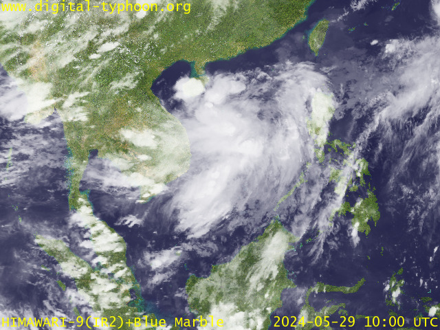
RECENT MTSAT-1R SATELLITE IMAGE:

> Image source: Digital-Typhoon.org (Nat'l. Institute of Informatics) (http://www.digital-typhoon.org )
__________________________________________________________________________________________
NOTES:

> Image source: Digital-Typhoon.
^ - JTWC commentary remarks (for Meteorologists) from their
latest warning.
latest warning.
* - Based on PAGASA's Philippine Storm Warning Signals,
# 4 being the highest. Red letters indicate new areas
being hoisted. For more explanations on these signals,
visit: http://www.typhoon2000.ph/signals.htm
** - Based on the Tropical Cyclone's Wave Height near
its center.
__________________________________________________________________________________________
>> To know the meteorological terminologies and acronyms
used on this update visit the ff:
http://typhoon2000.ph/tcterm.htm
http://www.nhc.noaa.gov/aboutgloss.shtml
http://www.srh.noaa.gov/oun/severewx/glossary.php
http://www.srh.weather.gov/fwd/glossarynation.html
http://www.nhc.noaa.gov/acronyms.shtml
__________________________________________________________________________________________
:: Typhoon2000.com (T2K) Mobile >> Powered by: Synermaxx
Receive the latest storm updates directly to your mobile phones! To know more:
Send T2K HELP to: 2800 (GLOBE & TM) | 216 (SMART & TNT) | 2288 (SUN)
Note: Globe & Smart charges P2.50 per message, while Sun at P2.00.
__________________________________________________________________________________________
For the complete details on TY PEIPAH (KABAYAN)...go visit
our website @:
> http://www.typhoon2000.com
> http://www.maybagyo.com
# 4 being the highest. Red letters indicate new areas
being hoisted. For more explanations on these signals,
visit: http://www.typhoon2
** - Based on the Tropical Cyclone's Wave Height near
its center.
____________
>> To know the meteorological terminologies and acronyms
used on this update visit the ff:
http://typhoon2000.
http://www.nhc.
http://www.srh.
http://www.srh.
http://www.nhc.
____________
:: Typhoon2000.
Receive the latest storm updates directly to your mobile phones! To know more:
Send T2K HELP to: 2800 (GLOBE & TM) | 216 (SMART & TNT) | 2288 (SUN)
Note: Globe & Smart charges P2.50 per message, while Sun at P2.00.
For the complete details on TY PEIPAH (KABAYAN)...
our website @:
> http://www.typhoon2
> http://www.maybagyo
Change settings via the Web (Yahoo! ID required)
Change settings via email: Switch delivery to Daily Digest | Switch format to Traditional
Visit Your Group | Yahoo! Groups Terms of Use | Unsubscribe
.
__,_._,___
No comments:
Post a Comment