
Typhoon2000 STORM UPDATE #001
Name: TROPICAL DEPRESSION ROLLY [94W]
Issued: 1:00 PM MANILA TIME (05:00 GMT) SAT 08 NOVEMBER 2008
Source: PAGASA SEVERE WEATHER BULLETIN #002
Note: Kindly refer to your country's official warnings or bulletins. This update is for additional information purposes only.
Source: PAGASA SEVERE WEATHER BULLETIN #002
Note: Kindly refer to your country's official warnings or bulletins. This update is for additional information purposes only.
_____________________________________________________________________________
TROPICAL DEPRESSION ROLLY (94W) NEWLY-F0RMED NOW OFF THE WATERS
OF BOHOL SEA...APPROACHING THE VISAYAN ISLANDS OF BOHOL, CEBU AND
NEGROS. WIDESPREAD RAINS WITH ACCOMPANYING SQUALLS (AKA. "SUBASKO")
WITHIN ITS RAINBANDS CAN BE EXPECTED ACROSS VISAYAS AND NORTHERN
MINDANAO.
*Interests along the Visayas should closely monitor the progress of ROLLY.
+ FORECAST OUTLOOK: ROLLY is expected to slow down due to a possible
interaction with TS MAYSAK (QUINTA) situated over the South China
*Interests along the Visayas should closely monitor the progress of ROLLY.
+ FORECAST OUTLOOK: ROLLY is expected to slow down due to a possible
interaction with TS MAYSAK (QUINTA) situated over the South China
Sea...its center is forecast to cross Central Visayas throughout
the day. ROLLY shall be off the western coast of Panay Island
tomorrow morning.
+ EFFECTS: ROLLY's developing rainbands continues to affect Northern
+ EFFECTS: ROLLY's developing rainbands continues to affect Northern
Mindanao and is now spreading across the whole of the Visayas. These
bands is expected to bring widespread rains with passing moderate to
strong squalls...with wind gusts not in excess of 55 kph. 1-day rainfall
accumulations of 100 up to 200 mm is possible along its rain bands...
with isolated accumulations of up to 300 mm along mountain slopes and
near the center of ROLLY. Residents in low-lying areas & steep slopes
must remain alert & seek evacuation for possible life-threatening flash
floods, mudslides & landslides due to the anticipated heavy rains brought
about by this system. Precautionary measures must be initiated if
necessary.
Important Note: Please keep in mind that the above forecast outlook,
effects & current monsoon intensity, and tropical cyclone watch changes
every 06 to 12 hours!
_____________________________________________________________________________
TIME/DATE: 10:00 AM MANILA TIME (02:00 GMT) SAT 08 NOV 2008
LOCATION OF CENTER: LATITUDE 9.8º N...LONGITUDE 125.2º E
DISTANCE 1: 35 KM (20 NM) WNW OF SURIGAO CITY, PH
DISTANCE 2: 155 KM (83 NM) EAST OF TAGBILARAN CITY, PH
DISTANCE 3: 155 KM (83 NM) ESE OF CEBU CITY, PH
effects & current monsoon intensity, and tropical cyclone watch changes
every 06 to 12 hours!
____________
LOCATION OF CENTER: LATITUDE 9.8º N...LONGITUDE 125.2º E
DISTANCE 1: 35 KM (20 NM) WNW OF SURIGAO CITY, PH
DISTANCE 2: 155 KM (83 NM) EAST OF TAGBILARAN CITY, PH
DISTANCE 3: 155 KM (83 NM) ESE OF CEBU CITY, PH
DISTANCE 4: 215 KM (115 NM) ENE OF DUMAGUETE CITY, PH
DISTANCE 5: 275 KM (148 NM) ESE OF BACOLOD CITY, PH
DISTANCE 6: 300 KM (162 NM) ESE OF ILOILO CITY, PH
DISTANCE 5: 275 KM (148 NM) ESE OF BACOLOD CITY, PH
DISTANCE 6: 300 KM (162 NM) ESE OF ILOILO CITY, PH
MAX WINDS [10-MIN AVG]: 45 KM/HR (25 KTS) NEAR THE CENTER
PEAK WIND GUSTS: 65 KM/HR (35 KTS)
SAFFIR-SIMPSON SCALE: TROPICAL DEPRESSION
COASTAL STORM SURGE HEIGHT: 0 FEET (0 METERS)
MINIMUM CENTRAL PRESSURE (est.): 1005 MILLIBARS (hPa)
RECENT MOVEMENT: WNW @ 19 KM/HR (10 KTS)
GENERAL DIRECTION: BOHOL-CEBU-NEGROS AREA
STORM'S SIZE (IN DIAMETER): 370 KM (200 NM)/AVERAGE
MAX WAVE HEIGHT**: 10 FEET (3.0 METERS)
VIEW PAGASA TRACKING MAP: 10 AM MANILA TIME SAT NOV 08
PHILIPPINE STORM SIGNALS*:
#01 - NEGROS ISLAND, ILOILO, GUIMARAS IS., CAPIZ, LEYTE, SOUTHERN LEYTE,
BOHOL, CEBU, CAMOTES IS., SIQUIJOR IS., SURIGAO DEL NORTE, SURIGAO
DEL SUR, SIARGAO IS., DINAGAT IS., AGUSAN DEL SUR, AGUSAN DEL NORTE,
MISAMIS ORIENTAL & CAMIGUIN IS.
24, 48 & 72 HR. FORECAST:MISAMIS ORIENTAL & CAMIGUIN IS.
8 AM (00 GMT) 09 NOVEMBER: 10.9N 121.5E
8 AM (00 GMT) 10 NOVEMBER: 12.5N 117.7E
8 AM (00 GMT) 11 NOVEMBER: 14.8N 114.0E
REMARKS: 8 AM (00 GMT) 08 NOVEMBER POSITION: 9.8N 125.5E.
REMARKS: 8 AM (00 GMT) 08 NOVEMBER POSITION: 9.8N 125.5E.
____________
RECENT PAGASA TRACKING CHART:

________________________
RECENT MTSAT-1R SATELLITE IMAGE:
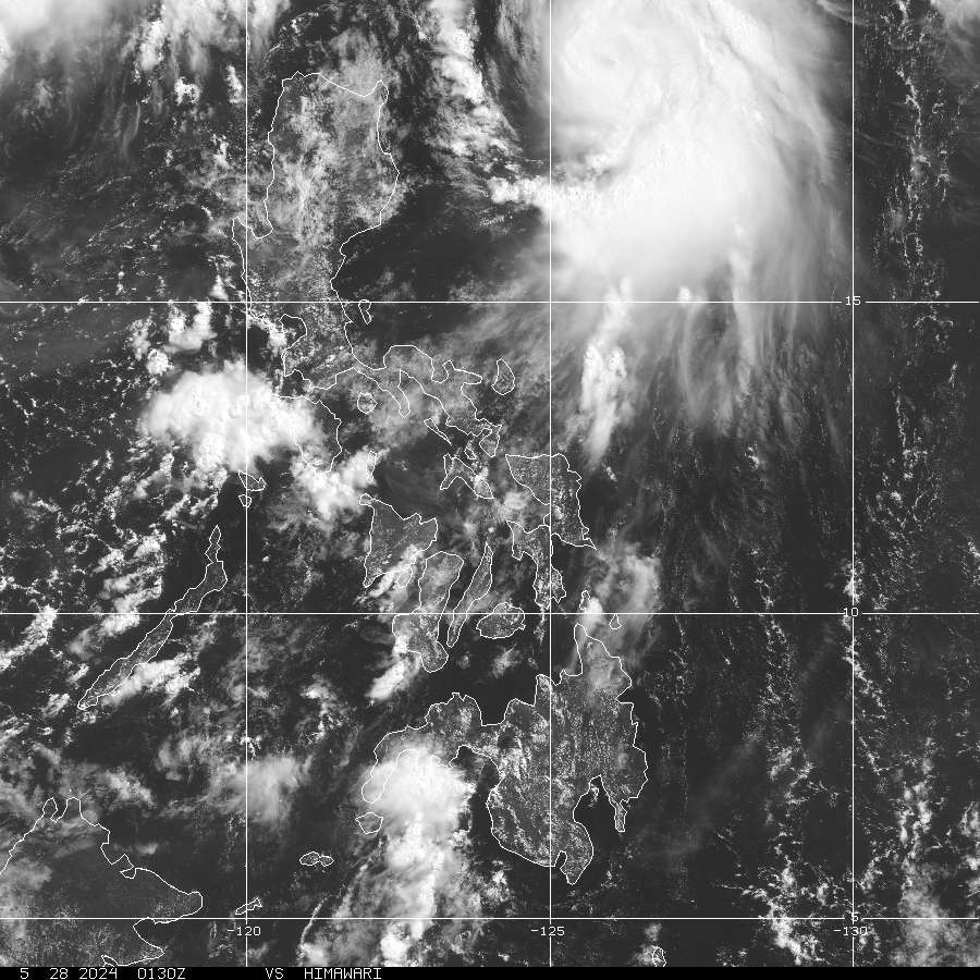
> Image source: NOAA Satellite Service (http://www.noaa.gov/ )
__________________________________________________________________________________________
NOTES:
> Image source: NOAA Satellite Service (http://www.noaa.
____________
^ - JTWC commentary remarks (for Meteorologists) from their
latest warning.
latest warning.
* - Based on PAGASA's Philippine Storm Warning Signals,
# 4 being the highest. For more explanations on these
signals, visit: http://www.typhoon2000.ph/signals.htm
** - Based on the Tropical Cyclone's Wave Height near
its center.
__________________________________________________________________________________________
>> To know the meteorological terminologies and acronyms
used on this update visit the ff:
http://typhoon2000.ph/tcterm.htm
http://www.nhc.noaa.gov/aboutgloss.shtml
http://www.srh.noaa.gov/oun/severewx/glossary.php
http://www.srh.weather.gov/fwd/glossarynation.html
http://www.nhc.noaa.gov/acronyms.shtml
__________________________________________________________________________________________
:: Typhoon2000.com (T2K) Mobile >> Powered by: Synermaxx
Receive the latest 6-hrly storm updates directly to your mobile phones! To get:
Send T2K TYPHOON to: 2800 (GLOBE & TM) | 216 (SMART & TNT) | 2288 (SUN)
Note: Globe & Smart charges P2.50 per message, while Sun at P2.00.
__________________________________________________________________________________________
For the complete details on TD ROLLY (94W)...go visit
our website @:
> http://www.typhoon2000.com
> http://www.maybagyo.com
# 4 being the highest. For more explanations on these
signals, visit: http://www.typhoon2
** - Based on the Tropical Cyclone's Wave Height near
its center.
____________
>> To know the meteorological terminologies and acronyms
used on this update visit the ff:
http://typhoon2000.
http://www.nhc.
http://www.srh.
http://www.srh.
http://www.nhc.
____________
:: Typhoon2000.
Receive the latest 6-hrly storm updates directly to your mobile phones! To get:
Send T2K TYPHOON to: 2800 (GLOBE & TM) | 216 (SMART & TNT) | 2288 (SUN)
Note: Globe & Smart charges P2.50 per message, while Sun at P2.00.
For the complete details on TD ROLLY (94W)...go visit
our website @:
> http://www.typhoon2
> http://www.maybagyo
Copyright © 2008 Typhoon2000.
Change settings via the Web (Yahoo! ID required)
Change settings via email: Switch delivery to Daily Digest | Switch format to Traditional
Visit Your Group | Yahoo! Groups Terms of Use | Unsubscribe
.
__,_._,___

No comments:
Post a Comment