
Typhoon2000 STORM UPDATE #002
Name: TROPICAL DEPRESSION ROLLY [94W]
Issued: 7:00 AM MANILA TIME (23:00 GMT) SUN 09 NOVEMBER 2008
Source: PAGASA SEVERE WEATHER BULLETIN #005
Note: Kindly refer to your country's official warnings or bulletins. This update is for additional information purposes only.
Source: PAGASA SEVERE WEATHER BULLETIN #005
Note: Kindly refer to your country's official warnings or bulletins. This update is for additional information purposes only.
_____________________________________________________________________________
ROLLY (94W) BARELY A TROPICAL DEPRESSION AS MOST OF ITS RAIN CLOUDS
DISSIPATES...NOW OFF THE ISLANDS OF THE CALAMIAN.
+ FORECAST OUTLOOK: ROLLY's life is at stake as it encounters strong shear
+ FORECAST OUTLOOK: ROLLY's life is at stake as it encounters strong shear
from the southern outflow-flanks of the much powerful MAYSAK (located off
the South China Sea)...The system is likely to be absorbed into the sou-
thern portion of MAYSAK if it does continue on its WNW track. Satellite
signature on this system no longer shows a distinct TD characteristics,
therefore a possible dissipation of ROLLY is most likely today.
+ EFFECTS: ROLLY's dissipating circulation has become scattered..just
+ EFFECTS: ROLLY's dissipating circulation has become scattered..just
affecting the small islands of the Calamian, Mindoro, Northern Palawan
...with some displaced eastern bands along Romblon-Tablas-Boracay Islands
including Panay Island. These scattered bands is expected to bring wide-
spread rains with passing moderate to strong squalls...with wind gusts
not in excess of 55 kph. 1-day rainfall accumulations of 50 up to 150 mm
is possible along its rain bands...with isolated accumulations of up to
200 mm along mountain slopes. Residents in low-lying areas & steep slopes
must remain alert & seek evacuation for possible life-threatening flash
floods, mudslides & landslides due to the anticipated heavy rains brought
about by this system. Precautionary measures must be initiated if
necessary.
Important Note: Please keep in mind that the above forecast outlook,
effects & current monsoon intensity, and tropical cyclone watch changes
every 06 to 12 hours!
_____________________________________________________________________________
TIME/DATE: 4:00 AM MANILA TIME (20:00 GMT) SUN 09 NOV 2008
LOCATION OF CENTER: LATITUDE 11.4º N...LONGITUDE 119.8º E
DISTANCE 1: 80 KM (43 NM) SSW OF CORON, PALAWAN, PH
DISTANCE 2: 140 KM (75 NM) WNW OF CUYO ISLAND, PH
DISTANCE 3: 235 KM (127 NM) WSW OF BORACAY, PH
effects & current monsoon intensity, and tropical cyclone watch changes
every 06 to 12 hours!
____________
LOCATION OF CENTER: LATITUDE 11.4º N...LONGITUDE 119.8º E
DISTANCE 1: 80 KM (43 NM) SSW OF CORON, PALAWAN, PH
DISTANCE 2: 140 KM (75 NM) WNW OF CUYO ISLAND, PH
DISTANCE 3: 235 KM (127 NM) WSW OF BORACAY, PH
DISTANCE 4: 170 KM (93 NM) SW OF SAN JOSE, OCCIDENTAL MINDORO, PH
DISTANCE 5: 225 KM (122 NM) NNE OF PUERTO PRINCESA CITY, PH
DISTANCE 5: 225 KM (122 NM) NNE OF PUERTO PRINCESA CITY, PH
MAX WINDS [10-MIN AVG]: 45 KM/HR (25 KTS) NEAR THE CENTER
PEAK WIND GUSTS: 65 KM/HR (35 KTS)
SAFFIR-SIMPSON SCALE: TROPICAL DEPRESSION
COASTAL STORM SURGE HEIGHT: 0 FEET (0 METERS)
MINIMUM CENTRAL PRESSURE (est.): 1005 MILLIBARS (hPa)
RECENT MOVEMENT: WNW @ 20 KM/HR (11 KTS)
GENERAL DIRECTION: SOUTH CHINA SEA
STORM'S SIZE (IN DIAMETER): 370 KM (200 NM)/AVERAGE
MAX WAVE HEIGHT**: 10 FEET (3.0 METERS)
VIEW PAGASA TRACKING MAP: 2 AM MANILA TIME SUN NOV 09
PHILIPPINE STORM SIGNALS*:
#01 - MINDORO, LUBANG ISLAND, NORTHERN PALAWAN, CALAMIAN GROUP &
CUYO ISLAND.
24, 48 HR. FORECAST:PEAK WIND GUSTS: 65 KM/HR (35 KTS)
SAFFIR-SIMPSON SCALE: TROPICAL DEPRESSION
COASTAL STORM SURGE HEIGHT: 0 FEET (0 METERS)
MINIMUM CENTRAL PRESSURE (est.): 1005 MILLIBARS (hPa)
RECENT MOVEMENT: WNW @ 20 KM/HR (11 KTS)
GENERAL DIRECTION: SOUTH CHINA SEA
STORM'S SIZE (IN DIAMETER): 370 KM (200 NM)/AVERAGE
MAX WAVE HEIGHT**: 10 FEET (3.0 METERS)
VIEW PAGASA TRACKING MAP: 2 AM MANILA TIME SUN NOV 09
PHILIPPINE STORM SIGNALS*:
#01 - MINDORO, LUBANG ISLAND, NORTHERN PALAWAN, CALAMIAN GROUP &
CUYO ISLAND.
2 AM (18 GMT) 10 NOVEMBER: 13.6N 116.3E
2 AM (18 GMT) 11 NOVEMBER: 16.4N 114.4E
REMARKS: 2 AM (18 GMT) 09 NOVEMBER POSITION: 11.2N 120.2E.
____________
RECENT PAGASA TRACKING CHART:

________________________
RECENT MTSAT-1R SATELLITE IMAGE:
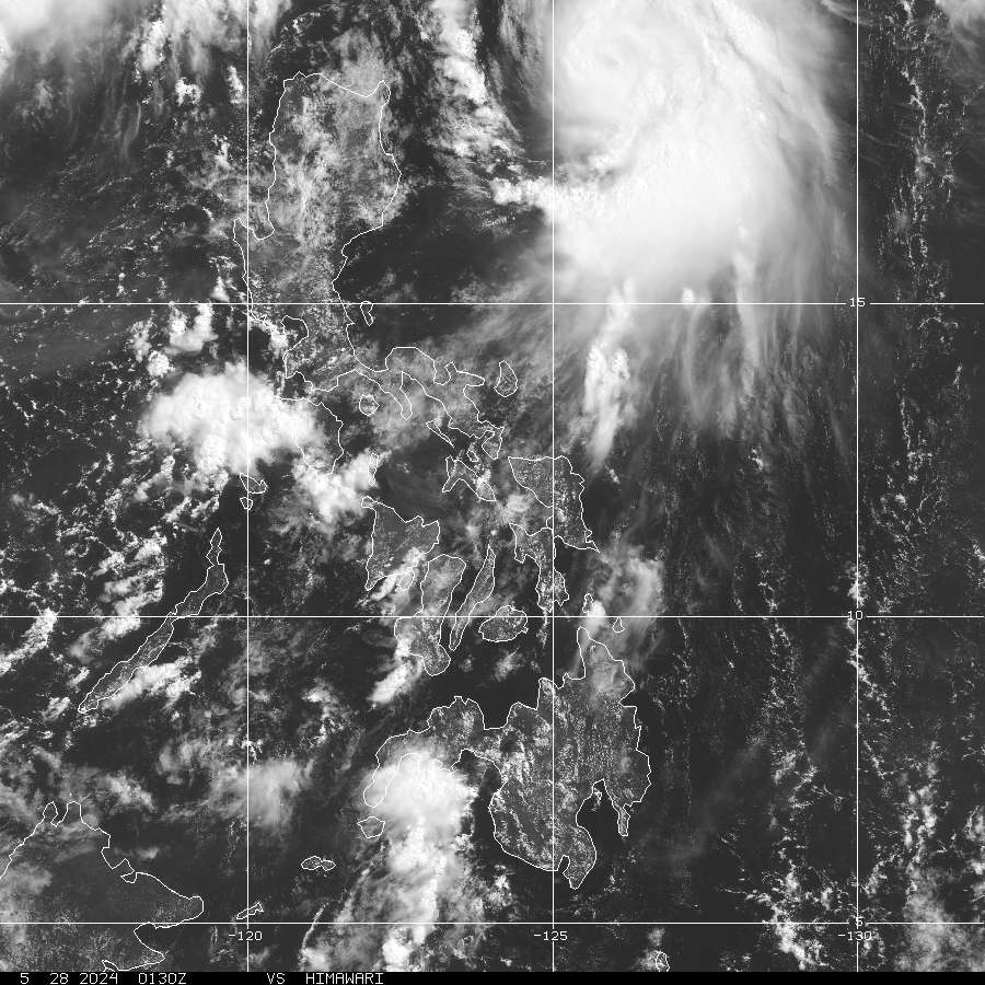
> Image source: NOAA Satellite Service (http://www.noaa.gov/ )
__________________________________________________________________________________________
NOTES:
> Image source: NOAA Satellite Service (http://www.noaa.
____________
^ - JTWC commentary remarks (for Meteorologists) from their
latest warning.
latest warning.
* - Based on PAGASA's Philippine Storm Warning Signals,
# 4 being the highest. For more explanations on these
signals, visit: http://www.typhoon2000.ph/signals.htm
** - Based on the Tropical Cyclone's Wave Height near
its center.
__________________________________________________________________________________________
>> To know the meteorological terminologies and acronyms
used on this update visit the ff:
http://typhoon2000.ph/tcterm.htm
http://www.nhc.noaa.gov/aboutgloss.shtml
http://www.srh.noaa.gov/oun/severewx/glossary.php
http://www.srh.weather.gov/fwd/glossarynation.html
http://www.nhc.noaa.gov/acronyms.shtml
__________________________________________________________________________________________
:: Typhoon2000.com (T2K) Mobile >> Powered by: Synermaxx
Receive the latest 6-hrly storm updates directly to your mobile phones! To get:
Send T2K TYPHOON to: 2800 (GLOBE & TM) | 216 (SMART & TNT) | 2288 (SUN)
Note: Globe & Smart charges P2.50 per message, while Sun at P2.00.
__________________________________________________________________________________________
For the complete details on TD ROLLY (94W)...go visit
our website @:
> http://www.typhoon2000.com
> http://www.maybagyo.com
# 4 being the highest. For more explanations on these
signals, visit: http://www.typhoon2
** - Based on the Tropical Cyclone's Wave Height near
its center.
____________
>> To know the meteorological terminologies and acronyms
used on this update visit the ff:
http://typhoon2000.
http://www.nhc.
http://www.srh.
http://www.srh.
http://www.nhc.
____________
:: Typhoon2000.
Receive the latest 6-hrly storm updates directly to your mobile phones! To get:
Send T2K TYPHOON to: 2800 (GLOBE & TM) | 216 (SMART & TNT) | 2288 (SUN)
Note: Globe & Smart charges P2.50 per message, while Sun at P2.00.
For the complete details on TD ROLLY (94W)...go visit
our website @:
> http://www.typhoon2
> http://www.maybagyo
Copyright © 2008 Typhoon2000.
Change settings via the Web (Yahoo! ID required)
Change settings via email: Switch delivery to Daily Digest | Switch format to Traditional
Visit Your Group | Yahoo! Groups Terms of Use | Unsubscribe
.
__,_._,___

No comments:
Post a Comment