
for Friday, 16 October 2009 [7:08 PM PST]


<<<Typhoon2000.com Mobile >>>
Get the latest 6-hrly SMS Storm Alerts on RAMIL!
For more details: Text T2K TYPHOON to
2800 (Globe/TM) | 216 (Smart/TNT) | 2288 (Sun)
*only P2.50 (Smart/Globe) / P2.00 (Sun) per msg received.
powered by: Synermaxx
Typhoon2000 (T2K) NEWS (Fri October 16 2009):
Currently issuing 6-hrly advisories (except 12:00 AM) on TS LUPIT (RAMIL)
LUPIT (RAMIL) MAX WIND SPEED PER AGENCY:
+ USA (JTWC/1-min avg): 120 km/hr
+ Korea (KMA/10-min avg): 105 km/hr
+ Japan (JMA/10-min avg): 100 km/hr
+ Taiwan (CWB/10-min avg): 100 km/hr
+ Philippines (PAGASA/10-min avg): 95 km/hr
+ Beijing (NMC/2-min avg): 85 kph
TYPHOON LUPIT [RAMIL/22W/0920]
T2K PUBLIC ADVISORY NUMBER 008
6:00 PM PST (10:00 GMT) Fri 16 October 2009
Source: T2K ANALYSIS / JTWC WARNING #010
View: Advisory Archives (2004-2009)
LUPIT (22W) has quickly entered the Philippine Area of Responsibility and intensified into a 120-kph Typhoon...now locally named as RAMIL...threatens Extreme Northern Luzon.
*Residents and visitors along Northern & Central Luzon should closely monitor the progress of LUPIT (RAMIL).
*Kindly refer to your local warnings & bulletins issued by your country's official weather agency. This advisory is intended for additional information purposes only.
+ Forecast Outlook: LUPIT is expected to slow-down beginning tomorrow until Sunday Oct 18 as a mid-latitude low pressure (trough) passes to the north of LUPIT. The 2 to 5-day Long-Range Forecast shows LUPIT resuming its WNW or Westward track as a new High Pressure Steering Ridge off Taiwan develops, driving LUPIT towards Extreme Northern Luzon between Monday to Wednesday (Oct 19-21). *Initial Impact Forecast (IIF): LUPIT shall make landfall over Cagayan on Wednesday afternoon, Oct 21 and exit thru Ilocos Provinces early Thursday morning (Oct 22) - a track similar to the recent Typhoon PARMA (PEPENG). Please be reminded that the IIF changes every 6 hours, so a shift to the left or right of its future track and other conditions must be considered.
+ Effects: LUPIT's circulation remains at sea, becoming larger and fully organized. Its southern outer feeder bands now expected to leave Ulithi and Yap Islands - where improving weather conditions can be expected tomorrow. 1-day rainfall accumulations of 50 up to 100 mm (moderate to heavy rain) can be expected along its rainbands...with isolated accumulations of up to 200 mm (very heavy rain) near the center of LUPIT particularly along its projected path.
[Important Note: Please keep in mind that the above forecast outlook, effects, current monsoon intensity, & tropical cyclone watch changes every 6 to 12 hrs!]
Time/Date: 6:00 PM PST Fri October 16 2009
Location of Eye: 14.4º N Lat 134.7º E Lon
Distance 1: 1,125 km (608 nm) ENE of Virac, Catanduanes
Distance 2: 1,165 km (630 nm) ENE of Gota Beach, Caramoan
Distance 3: 1,245 km (673 nm) ENE of Metro Naga/CWC
Distance 4: 1,465 km (790 nm) East of Metro Manila
MaxWinds (1-min avg): 120 kph (65 kts) near the center
Peak Wind Gusts: 150 kph (80 kts)
Saffir-Simpson Typhoon Scale: Category 1
Coastal Storm Surge Height: 4-5 feet [1.2-1.7 m]
Minimum Central Pressure: 974 millibars (hPa)
Recent Movement: WNW @ 33 kph (18 kts)
Projected Area of Impact: Extreme Northern Luzon
Size (in Diameter): 740 km (400 nm) / Large
Max Sea Wave Height (near center): 17 ft (5.1 m)
T2K TrackMap #006 (for Public): 8 PM PST Fri Oct 16
JTWC Ship Avoidance TrackMap: 2 PM Fri Oct 16
Multi-Agency Forecast TrackMap: 2 PM Fri Oct 16
TSR Wind Probabilities: Current to 5-days Ahead
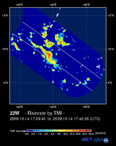
NASA-JAXA TMI Image: Latest Rainrate 01
Zoomed Satellite Pic: Near Real-Time
Wunderground Animation: 6-12 hr. GIF Loop
JTWC (US NAVY/AIR FORCE) 12, 24, 48 & 72 HR. FORECAST & REMARKS:
2 AM (18 GMT) 17 OCTOBER: 14.7N 134.0E / 140-165 KPH (TY-Cat 1) / WNW @ 13 KPH
<<<Typhoon2000.
Get the latest 6-hrly SMS Storm Alerts on RAMIL!
For more details: Text T2K TYPHOON to
2800 (Globe/TM) | 216 (Smart/TNT) | 2288 (Sun)
*only P2.50 (Smart/Globe) / P2.00 (Sun) per msg received.
powered by: Synermaxx
Typhoon2000 (T2K) NEWS (Fri October 16 2009):
Currently issuing 6-hrly advisories (except 12:00 AM) on TS LUPIT (RAMIL)
LUPIT (RAMIL) MAX WIND SPEED PER AGENCY:
+ USA (JTWC/1-min avg): 120 km/hr
+ Korea (KMA/10-min avg): 105 km/hr
+ Japan (JMA/10-min avg): 100 km/hr
+ Taiwan (CWB/10-min avg): 100 km/hr
+ Philippines (PAGASA/10-min avg): 95 km/hr
+ Beijing (NMC/2-min avg): 85 kph
TYPHOON LUPIT [RAMIL/22W/0920]
T2K PUBLIC ADVISORY NUMBER 008
6:00 PM PST (10:00 GMT) Fri 16 October 2009
Source: T2K ANALYSIS / JTWC WARNING #010
View: Advisory Archives (2004-2009)
*Residents and visitors along Northern & Central Luzon should closely monitor the progress of LUPIT (RAMIL).
*Kindly refer to your local warnings & bulletins issued by your country's official weather agency. This advisory is intended for additional information purposes only.
+ Forecast Outlook: LUPIT is expected to slow-down beginning tomorrow until Sunday Oct 18 as a mid-latitude low pressure (trough) passes to the north of LUPIT. The 2 to 5-day Long-Range Forecast shows LUPIT resuming its WNW or Westward track as a new High Pressure Steering Ridge off Taiwan develops, driving LUPIT towards Extreme Northern Luzon between Monday to Wednesday (Oct 19-21). *Initial Impact Forecast (IIF): LUPIT shall make landfall over Cagayan on Wednesday afternoon, Oct 21 and exit thru Ilocos Provinces early Thursday morning (Oct 22) - a track similar to the recent Typhoon PARMA (PEPENG). Please be reminded that the IIF changes every 6 hours, so a shift to the left or right of its future track and other conditions must be considered.
+ Effects: LUPIT's circulation remains at sea, becoming larger and fully organized. Its southern outer feeder bands now expected to leave Ulithi and Yap Islands - where improving weather conditions can be expected tomorrow. 1-day rainfall accumulations of 50 up to 100 mm (moderate to heavy rain) can be expected along its rainbands...
Time/Date: 6:00 PM PST Fri October 16 2009
Location of Eye: 14.4º N Lat 134.7º E Lon
Distance 1: 1,125 km (608 nm) ENE of Virac, Catanduanes
Distance 2: 1,165 km (630 nm) ENE of Gota Beach, Caramoan
Distance 3: 1,245 km (673 nm) ENE of Metro Naga/CWC
Distance 4: 1,465 km (790 nm) East of Metro Manila
MaxWinds (1-min avg): 120 kph (65 kts) near the center
Peak Wind Gusts: 150 kph (80 kts)
Saffir-Simpson Typhoon Scale: Category 1
Coastal Storm Surge Height: 4-5 feet [1.2-1.7 m]
Minimum Central Pressure: 974 millibars (hPa)
Recent Movement: WNW @ 33 kph (18 kts)
Projected Area of Impact: Extreme Northern Luzon
Size (in Diameter): 740 km (400 nm) / Large
Max Sea Wave Height (near center): 17 ft (5.1 m)
T2K TrackMap #006 (for Public): 8 PM PST Fri Oct 16
JTWC Ship Avoidance TrackMap: 2 PM Fri Oct 16
Multi-Agency Forecast TrackMap: 2 PM Fri Oct 16
TSR Wind Probabilities: Current to 5-days Ahead
NASA-JAXA TMI Image: Latest Rainrate 01
Zoomed Satellite Pic: Near Real-Time
Wunderground Animation: 6-12 hr. GIF Loop
2 AM (18 GMT) 17 OCTOBER: 14.7N 134.0E / 140-165 KPH (TY-Cat 1) / WNW @ 13 KPH
2 PM (06 GMT) 17 OCTOBER: 15.3N 132.8E / 165-205 KPH (TY-Cat 2) / NW @ 07 KPH
2 PM (06 GMT) 18 OCTOBER: 16.3N 131.4E / 215-260 KPH (TY-Cat 4) / WNW @ 09 KPH
2 PM (06 GMT) 19 OCTOBER: 16.9N 129.6E / 215-260 KPH (TY-Cat 4) / W @ 13 KPH
2 PM (06 GMT) 18 OCTOBER: 16.3N 131.4E / 215-260 KPH (TY-Cat 4) / WNW @ 09 KPH
2 PM (06 GMT) 19 OCTOBER: 16.9N 129.6E / 215-260 KPH (TY-Cat 4) / W @ 13 KPH
REMARKS: 2 PM (06 GMT) FRI 16 OCTOBER POSITION: 13.9N 136.0E.
*ANIMATED MULTISPECTRAL IMAGERY SHOWS A TIGHTLY
WRAPPED SYSTEM WITH A BANDING EYE AND ANIMATED WATER VAPOR IMAGERY
ILLUSTRATES EXCELLENT POLEWARD OUTFLOW INTO THE MID-LATITUDE
WESTERLIES AS THE SYSTEM IS TRACKING SOUTH OF THE VERY NARROW (ONLY
ABOUT FIVE DEGREES, NORTH TO SOUTH) SUBTROPICAL RIDGE. THE CURRENT
INTENSITY IS AN AVERAGE OF DVORAK ESTIMATES FROM PGTW (T4.5), KNES
(T4.0) AND RJTD (T3.5). THE CURRENT POSITION IS BASED ON THE PGTW
POSITION FIX AND IS SUPPORTED BY THE 160444Z AMSRE MICROWAVE IMAGE
WHICH CAPTURES THE WRAPPING CONVECTION AND DEPICTS A MICROWAVE EYE.
TY LUPIT IS STILL EXPECTED TO SLOW IN FORWARD TRACK SPEED IN THE
NEXT DAY OR TWO AS THE APPROACHING MID-LATITUDE TROUGH WEAKENS THE
STEERING INFLUENCE. THOUGH THE NUMERICAL MODELS STILL DIFFER ON THE
DEGREE TO WHICH THE TROUGH WILL AFFECT THE SPEED AND POLEWARD TURN
OF LUPIT, THEY HAVE COME INTO VERY GOOD AGREEMENT ON AN EXTENDED
TRACK TOWARDS NORTHERN LUZON...(more)
>> LUPIT, meaning: Cruel; viciousness. Name contributed by: Philippines.
____________
_______________________________________________________________________________________________________________________________________
RECENT TYPHOON2000.

________________________
RECENT MTSAT-1R SATELLITE IMAGE:

> Image source: NOAA SATELLITE CENTER
RECENT WUNDERGROUND SATELLITE ANIMATION:

> Image source: Wunderground.com (http://www.wunderground.com/ ) ____________________________________________________________________________________________________________________
> Image source: NOAA SATELLITE CENTER
____________________________________________________________________________________________________________________
RECENT WUNDERGROUND SATELLITE ANIMATION:
> Image source: Wunderground.
NOTE:
^ - JTWC commentary remarks (for Meteorologists) from their latest warning.
__________________________________________________________________________________________
>> To know the meteorological terminologies and acronyms used on this update visit the ff:
http://typhoon2000.ph/tcterm.htm
http://www.nhc.noaa.gov/aboutgloss.shtml
http://www.srh.noaa.gov/oun/severewx/glossary.php
http://www.srh.weather.gov/fwd/glossarynation.html
http://www.nhc.noaa.gov/acronyms.shtml
__________________________________________________________________________________________
For the complete details on TY LUPIT (RAMIL)...go visit our website @:
> http://www.typhoon2000.com
> http://www.maybagyo.com
>> To know the meteorological terminologies and acronyms used on this update visit the ff:
http://typhoon2000.
http://www.nhc.
http://www.srh.
http://www.srh.
http://www.nhc.
____________
> http://www.typhoon2
> http://www.maybagyo
Copyright © 2009 Typhoon2000.
__._,_.___
MARKETPLACE
Change settings via the Web (Yahoo! ID required)
Change settings via email: Switch delivery to Daily Digest | Switch format to Traditional
Visit Your Group | Yahoo! Groups Terms of Use | Unsubscribe
.
__,_._,___

No comments:
Post a Comment