
for Thursday, 01 October 2009 [5:40 AM PST]


<<<Typhoon2000.com Mobile >>>
Get the latest SMS Storm Alerts on PEPENG!
For more details: Text T2K TYPHOON to
2800 (Globe/TM) | 216 (Smart/TNT) | 2288 (Sun)
*only P2.50 (Smart/Globe) / P2.00 (Sun) per msg received.
powered by: Synermaxx
Typhoon2000 (T2K) NEWS (Thu October 01 2009):
PARMA is now a powerful Category 3 Typhoon as it rapidly intensified during the past 6 hours...Storm Warning Signals were now raised by PAGASA Manila across parts of Bicol...Just uploaded the initial flash satellite animation on the main page. Currently issuing 6-hrly advisories (except 12:00 AM) on Typhoon PARMA (PEPENG)...T2K StormTrack now loaded for viewing below.
PARMA (PEPENG) MAX WIND SPEED PER AGENCY:
+ USA (JTWC/1-min avg): 185 km/hr
+ Japan (JMA/10-min avg): 160 km/hr
+ Korea (KMA/10-min avg): 160 km/hr
+ Taiwan (CWB/10-min avg): 160 km/hr
+ Philippines (PAGASA/10-min avg): 150 km/hr
+ Beijing (NMC/2-min avg): 145 km/hr
TYPHOON PARMA [PEPENG/19W/0917]
T2K PUBLIC ADVISORY NUMBER 010
6:00 AM PST (22:00 GMT) Thu 01 October 2009
Source: T2K ANALYSIS / JTWC WARNING #013
View: Advisory Archives (2004-2009)
Powerful Typhoon PARMA (PEPENG) maintained its Category 3 strength while over the Philippine Sea...endangers Eastern Luzon.
*Residents and visitors along the east coast of Bicol Region, the rest of Luzon and Taiwan should closely monitor the progress of PARMA.
*Kindly refer to your local warnings & bulletins issued by your country's official weather agency. This advisory is intended for additional information purposes only.
+ Forecast Outlook: PARMA is expected to maintain its WNW track across the warm Philippine Sea and further intensify. The 2 to 5-day Long-Range Forecast shows the system at its closest point of approach (CPA) to Bicol Region - about 300 km. NE of Metro Naga/CWC on Friday evening, with Category 4 strength of 215-220 kph near its EYE...and shall slow down while approaching the Northeastern corner of Luzon (Cagayan-Isabela). The core (eye & eyewall) shall pass very close to the NE tip of Cagayan late Sunday afternoon (Oct 4) and shall further slow down but reaching Super Typhoon strength (240 kph) as it enters the Balintang Channel early Monday morning (Oct 5). PARMA shall pass directly or very close to the Batanes Group of Islands early Tuesday morning (Oct 6) as it moves towards Southern Taiwan.Please be aware that long-range forecast changes every now and then. Continued monitoring on this potential typhoon is a must for disaster preparedness agencies.
+ Effects: PARMA's circulation is slowly growing in size as it moves across the Philippine Sea...now an average tropical cyclone. Its outer (feeder) bands has approached the coastal areas of Visayas and the Bicol Region including Northern & Eastern Mindanao - passing rains, squalls, thunderstorms w/ gale-force winds may be expected along these areas today. Tropical Storm conditions w/ winds not exceeding 100 kph together with light to moderate to sometimes heavy rains can be expected along the coastal areas of Catanduanes, Albay, Sorsogon, & Camarines Provinces. While, the flood-stricken areas of Central and Southern Luzon including Metro Manila will be under the typhoon's outer bands tomorrow. 1-day rainfall accumulations of 50 up to 150 mm (moderate to heavy rain) can be expected along PARMA's rainbands...with isolated accumulations of up to 300 mm (very heavy rain) near the center of PARMA. People living around the slopes of Mayon Volcano in Albay & of Bulusan Volcano in Sorsogon - especially along the areas where possible MUDFLOWS (LAHAR) FLOWS (mixture of volcanic mud and water) are located must stay alert as moderate to heavy rains associated by this system are likely to affect the area beginning today. Residents in low-lying areas & steep slopes must remain alert & seek evacuation for possible life-threatening flash floods, mudslides & landslides due to the anticipated heavy rains brought about by this system. Precautionary measures must be initiated if necessary. Possible coastal Storm Surge flooding of 9 to 12 feet above normal tide levels...accompanied by large and dangerous battering waves...is possible along the coastal areas of Bicol Region, Samar & Eastern Luzon. Extensive damage is likely on this type of storm surge.
+ Tropical Cyclone Watch:
(1) Tropical Storm MELOR (20W) continues to gain strength as it moves towards the Marianas. Click here to view latest T2K advisory.
Kindly click the cool T2K Graphical Satellite Analysis, issued every afternoon, and shows various tropical systems roaming across the South China Sea and the Western Pacific Ocean.
[Important Note: Please keep in mind that the above forecast outlook, effects, current monsoon intensity, & tropical cyclone watch changes every 6 to 12 hrs!]
Time/Date: 6:00 AM PST Wed October 01 2009
Location of Pinhole Eye: 11.6º N Lat 131.6º E Lon
Distance 1: 675 km (365 nm) East of Borongan, E.Samar
Distance 2: 770 km (415 nm) ESE of Catarman, N.Samar
Distance 3: 835 km (452 nm) ESE of Virac, Catanduanes
Distance 4: 840 km (455 nm) ESE of Sorsogon City
Distance 5: 875 km (472 nm) ESE of Legazpi City/Masbate
Distance 6: 880 km (475 nm) ESE of Gota Beach Resort
Distance 7: 940 km (508 nm) ESE of Metro Naga/CWC
Distance 8: 985 km (532 nm) ESE of Metro Manila
Distance 9: 1,185 km (640 nm) ESE of Metro Manila
MaxWinds (1-min avg): 185 kph (100 kts) near the eye
Peak Wind Gusts: 230 kph (125 kts)
Saffir-Simpson Typhoon Scale: Category 3
Coastal Storm Surge Height: 9-12 feet [2.7-3.9 m]
Minimum Central Pressure: 956 millibars (hPa)
Recent Movement: WNW @ 28 kph (15 kts)
Projected Area of Impact: Northeastern Luzon
Size (in Diameter): 555 km (300 nm) / Average
Max Sea Wave Height (near center): 25 ft (7.6 m)
T2K TrackMap #02 (for Public): 6 AM PST Thu Oct 01
JTWC Ship Avoidance TrackMap: 18 GMT Wed Sep 30
Multi-Agency Forecast TrackMap: 2 AM Thu Oct 01
TSR Wind Probabilities: Current to 5-days Ahead
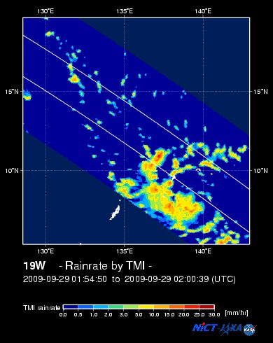
EORC-JAXA TRMM Viewer: Real-Time Rainrate Image new!
NASA-JAXA TMI Viewer: Latest Rainrate Image
Zoomed Satellite Pic: Near Real-Time
Wunderground Animation: 6-12 hr. GIF Loop
PHILIPPINE STORM WARNING SIGNAL # ONE (1)
Now In Effect: CAMARINES SUR, CAMARINES NORTE & CATANDUANES.
The above areas will have rains and winds of not more than 60 kph today. Coastal waters will be moderate to rough.
Residents living in low-lying and mountainous areas under Public Storm Warning Signal Number 1 are alerted against flashfloods, mudflows, mudslides and landslides.
JTWC (US NAVY/AIR FORCE) 12, 24, 48 & 72 HR. FORECAST & REMARKS:
2 PM (06 GMT) 01 OCTOBER: 12.8N 129.8E / 195-240 KPH (TY-Cat 3) / WNW @ 22 KPH
<<<Typhoon2000.
Get the latest SMS Storm Alerts on PEPENG!
For more details: Text T2K TYPHOON to
2800 (Globe/TM) | 216 (Smart/TNT) | 2288 (Sun)
*only P2.50 (Smart/Globe) / P2.00 (Sun) per msg received.
powered by: Synermaxx
Typhoon2000 (T2K) NEWS (Thu October 01 2009):
PARMA is now a powerful Category 3 Typhoon as it rapidly intensified during the past 6 hours...Storm Warning Signals were now raised by PAGASA Manila across parts of Bicol...Just uploaded the initial flash satellite animation on the main page. Currently issuing 6-hrly advisories (except 12:00 AM) on Typhoon PARMA (PEPENG)...T2K StormTrack now loaded for viewing below.
PARMA (PEPENG) MAX WIND SPEED PER AGENCY:
+ USA (JTWC/1-min avg): 185 km/hr
+ Japan (JMA/10-min avg): 160 km/hr
+ Korea (KMA/10-min avg): 160 km/hr
+ Taiwan (CWB/10-min avg): 160 km/hr
+ Philippines (PAGASA/10-min avg): 150 km/hr
+ Beijing (NMC/2-min avg): 145 km/hr
TYPHOON PARMA [PEPENG/19W/
T2K PUBLIC ADVISORY NUMBER 010
6:00 AM PST (22:00 GMT) Thu 01 October 2009
Source: T2K ANALYSIS / JTWC WARNING #013
View: Advisory Archives (2004-2009)
*Residents and visitors along the east coast of Bicol Region, the rest of Luzon and Taiwan should closely monitor the progress of PARMA.
*Kindly refer to your local warnings & bulletins issued by your country's official weather agency. This advisory is intended for additional information purposes only.
+ Forecast Outlook: PARMA is expected to maintain its WNW track across the warm Philippine Sea and further intensify. The 2 to 5-day Long-Range Forecast shows the system at its closest point of approach (CPA) to Bicol Region - about 300 km. NE of Metro Naga/CWC on Friday evening, with Category 4 strength of 215-220 kph near its EYE...and shall slow down while approaching the Northeastern corner of Luzon (Cagayan-Isabela)
+ Effects: PARMA's circulation is slowly growing in size as it moves across the Philippine Sea...now an average tropical cyclone. Its outer (feeder) bands has approached the coastal areas of Visayas and the Bicol Region including Northern & Eastern Mindanao - passing rains, squalls, thunderstorms w/ gale-force winds may be expected along these areas today. Tropical Storm conditions w/ winds not exceeding 100 kph together with light to moderate to sometimes heavy rains can be expected along the coastal areas of Catanduanes, Albay, Sorsogon, & Camarines Provinces. While, the flood-stricken areas of Central and Southern Luzon including Metro Manila will be under the typhoon's outer bands tomorrow. 1-day rainfall accumulations of 50 up to 150 mm (moderate to heavy rain) can be expected along PARMA's rainbands...
(1) Tropical Storm MELOR (20W) continues to gain strength as it moves towards the Marianas. Click here to view latest T2K advisory.
Kindly click the cool T2K Graphical Satellite Analysis, issued every afternoon, and shows various tropical systems roaming across the South China Sea and the Western Pacific Ocean.
[Important Note: Please keep in mind that the above forecast outlook, effects, current monsoon intensity, & tropical cyclone watch changes every 6 to 12 hrs!]
Time/Date: 6:00 AM PST Wed October 01 2009
Location of Pinhole Eye: 11.6º N Lat 131.6º E Lon
Distance 1: 675 km (365 nm) East of Borongan, E.Samar
Distance 2: 770 km (415 nm) ESE of Catarman, N.Samar
Distance 3: 835 km (452 nm) ESE of Virac, Catanduanes
Distance 4: 840 km (455 nm) ESE of Sorsogon City
Distance 5: 875 km (472 nm) ESE of Legazpi City/Masbate
Distance 6: 880 km (475 nm) ESE of Gota Beach Resort
Distance 7: 940 km (508 nm) ESE of Metro Naga/CWC
Distance 8: 985 km (532 nm) ESE of Metro Manila
Distance 9: 1,185 km (640 nm) ESE of Metro Manila
MaxWinds (1-min avg): 185 kph (100 kts) near the eye
Peak Wind Gusts: 230 kph (125 kts)
Saffir-Simpson Typhoon Scale: Category 3
Coastal Storm Surge Height: 9-12 feet [2.7-3.9 m]
Minimum Central Pressure: 956 millibars (hPa)
Recent Movement: WNW @ 28 kph (15 kts)
Projected Area of Impact: Northeastern Luzon
Size (in Diameter): 555 km (300 nm) / Average
Max Sea Wave Height (near center): 25 ft (7.6 m)
T2K TrackMap #02 (for Public): 6 AM PST Thu Oct 01
JTWC Ship Avoidance TrackMap: 18 GMT Wed Sep 30
Multi-Agency Forecast TrackMap: 2 AM Thu Oct 01
TSR Wind Probabilities: Current to 5-days Ahead
EORC-JAXA TRMM Viewer: Real-Time Rainrate Image new!
NASA-JAXA TMI Viewer: Latest Rainrate Image
Zoomed Satellite Pic: Near Real-Time
Wunderground Animation: 6-12 hr. GIF Loop
PHILIPPINE STORM WARNING SIGNAL # ONE (1)
Now In Effect: CAMARINES SUR, CAMARINES NORTE & CATANDUANES.
The above areas will have rains and winds of not more than 60 kph today. Coastal waters will be moderate to rough.
Residents living in low-lying and mountainous areas under Public Storm Warning Signal Number 1 are alerted against flashfloods, mudflows, mudslides and landslides.
2 PM (06 GMT) 01 OCTOBER: 12.8N 129.8E / 195-240 KPH (TY-Cat 3) / WNW @ 22 KPH
2 AM (18 GMT) 02 OCTOBER: 14.0N 127.6E / 205-250 KPH (TY-Cat 3) / WNW @ 17 KPH
2 AM (18 GMT) 03 OCTOBER: 16.0N 124.9E / 215-260 KPH (TY-Cat 4) / NW @ 11 KPH
2 AM (18 GMT) 04 OCTOBER: 17.6N 123.3E / 220-270 KPH (TY-Cat 4) / NNW @ 07 KPH
2 AM (18 GMT) 03 OCTOBER: 16.0N 124.9E / 215-260 KPH (TY-Cat 4) / NW @ 11 KPH
2 AM (18 GMT) 04 OCTOBER: 17.6N 123.3E / 220-270 KPH (TY-Cat 4) / NNW @ 07 KPH
REMARKS: 2 AM (18 GMT) 01 OCTOBER POSITION: 11.3N 132.5E.
*TYPHOON (TY) 19W (PARMA), LOCATED APPROXIMATELY 700 NM EAST-SOUTH-
EAST OF MANILA, PHILIPPINES, HAS TRACKED WEST-NORTHWESTWARD AT
15 KNOTS OVER THE PAST SIX HOURS. ANIMATED WATER VAPOR IMAGERY SHOWS
THE SYSTEM HAS SIGNIFICANTLY DEEPENED WITH MULTIPLE CONVECTIVE BANDS
WRAPPING TIGHTER INTO A WELL-DEFINED EYE. ADDITIONALLY, THE SYSTEM
IS EXHIBITING EXCELLENT POLEWARD OUTFLOW INTO A TROPICAL UPPER
TROPOSPHERIC TROUGH TO THE NORTH. CURRENT INTENSITY AND POSITION
ARE BASED ON DVORAK INTENSITY FIXES FROM PGTW AND RJTD. UPPER LEVEL
ANALYSIS INDICATES THE SYSTEM IS SOUTH OF THE RIDGE AXIS WITH A
DIVERGENT POINT SOURCE DIRECTLY OVERHEAD. TY 19W IS TRACKING ALONG
THE SOUTHWESTERN PERIPHERY OF A MID-LEVEL SUBTROPICAL RIDGE TO THE
NORTHEAST. IT IS EXPECTED TO CONTINUE ALONG THIS TRACK THROUGHOUT
THE FORECAST PERIOD AND SLOW DOWN IN FORWARD MOTION AFTER TAU 72
AS A WEAKNESS IN THE STEERING RIDGE DEVELOPS. FAVORABLE ENVIRON-
MENTAL CONDITIONS WILL ENSURE TYPHOON PARMA WILL CONTINUE TO
INTENSIFY AS IT TRACKS ALONG A CORRIDOR OF LOW TO MODERATE VERTICAL
WIND SHEAR AND INCREASING ALONG-TRACK SEA SURFACE TEMPERATURES.
AVAILABLE NUMERIC TRACK GUIDANCE ARE IN FAIR AGREEMENT UP TO TAU 48
WHERE THEY PROGRESSIVELY DIVERGE WITH JGSM AND TCLAPS TO THE EXTREME
RIGHT AND NOGAPS, WBAR, AND EGRR TO THE FAR LEFT. THIS TRACK
FORECAST IS JUST TO THE LEFT OF THE MIDDLE OF THE ENVELOPE...(more)
>> PARMA, meaning: Macanese food (ham with chicken livers and mushrooms). Name contributed by: Macau, China.
____________
PAGASA CURRENT POSITION, MOVEMENT AND INTENSITY (10-min. ave.):
> 4 AM (20 GMT) 01 OCTOBER: 11.5N 132.1E / WNW @ 24 kph / 150 kph
:: For the complete PAGASA bulletin, kindly visit their website at:
http://www.pagasa.dost.gov.ph/wb/tcupdate.shtml
_______________________________________________________________________________________________________________________________________
:: For the complete PAGASA bulletin, kindly visit their website at:
http://www.pagasa.
____________
RECENT NWS-GUAM TRACKING CHART:

________________________
RECENT MTSAT-1R SATELLITE IMAGE:

> Image source: NOAA SATELLITE CENTER
RECENT WUNDERGROUND SATELLITE ANIMATION: (EXPERIENCING TECHNICAL PROBLEMS)

> Image source: Wunderground.com (http://www.wunderground.com/ ) ____________________________________________________________________________________________________________________
> Image source: NOAA SATELLITE CENTER
____________________________________________________________________________________________________________________
RECENT WUNDERGROUND SATELLITE ANIMATION: (EXPERIENCING TECHNICAL PROBLEMS)
> Image source: Wunderground.
NOTE:
^ - JTWC commentary remarks (for Meteorologists) from their latest warning.
__________________________________________________________________________________________
>> To know the meteorological terminologies and acronyms used on this update visit the ff:
http://typhoon2000.ph/tcterm.htm
http://www.nhc.noaa.gov/aboutgloss.shtml
http://www.srh.noaa.gov/oun/severewx/glossary.php
http://www.srh.weather.gov/fwd/glossarynation.html
http://www.nhc.noaa.gov/acronyms.shtml
__________________________________________________________________________________________
For the complete details on TY PARMA (PEPENG)...go visit our website @:
> http://www.typhoon2000.com
> http://www.maybagyo.com
>> To know the meteorological terminologies and acronyms used on this update visit the ff:
http://typhoon2000.
http://www.nhc.
http://www.srh.
http://www.srh.
http://www.nhc.
____________
> http://www.typhoon2
> http://www.maybagyo
Copyright © 2009 Typhoon2000.
__._,_.___
Change settings via the Web (Yahoo! ID required)
Change settings via email: Switch delivery to Daily Digest | Switch format to Traditional
Visit Your Group | Yahoo! Groups Terms of Use | Unsubscribe
.
__,_._,___

No comments:
Post a Comment