
for Saturday, 17 July 2010 [6:16 PM PhT]

<<<Typhoon2000.
Get the latest 6-hrly SMS Storm Alerts on LPA 98W!
For more details: Text T2K TYPHOON to
2800 (Globe/TM) | 216 (Smart/TNT) | 2288 (Sun)
*only P2.50 (Smart/Globe) / P2.00 (Sun) per msg received.
powered by: Synermaxx
Typhoon2000 (T2K) NEWS (Sat July 17 2010):
Now initiating the 6-hrly updates web advisiories (except 12 AM HKT) on Tropical Disturbance 98W (LPA) developing near the coast of Aurora.
98W (LPA) MAX WIND SPEED PER AGENCY:
+ USA (JTWC/1-min avg): 25 km/hr
+ Japan (JMA/10-min avg): 45 km/hr
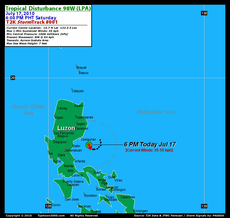
TROPICAL DISTURBANCE 98W [LPA]
T2K PUBLIC ADVISORY NUMBER 001
6:00 PM PhT (10:00 GMT) Sat 17 July 2010
Source: T2K Analysis/JTWC SatFix
View: Advisory Archives (2004-2010)
*Residents and visitors along Central & Northern Luzon particularly Aurora & Isabela should closely monitor the progress of 98W (LPA).
*Do not use this for life or death decision. This advisory is intended for additional information purposes only. Kindly refer to your country's official weather agency for local warnings, advisories & bulletins.
Current Storm Information + Forecast Outlook: This section will commence once this disturbance (LPA) has been upgraded into a Tropical Depression.
Time/Date: 6:00 PM PhT Sat Jul 17 2010
Location of Center: 15.7º N Lat 122.6º E Lon
Distance 1: 75 km (40 nm) SE of Casiguran, Aurora
Distance 2: 110 km (60 nm) East of Baler, Aurora
Distance 3: 165 km (90 nm) SE of Cauayan, Isabela
Distance 4: 225 km (122 nm) ESE of Baguio City
Distance 5: 250 km (135 nm) ESE of Dagupan City
Distance 6: 140 km (75 nm) NE of Infanta, Quezon
Distance 7: 200 km (108 nm) NE of Metro Manila
Distance 8: 240 km (130 nm) NNW of Metro Naga/CWC
MaxWinds (1-min avg): 35 kph (20 kts) near the center
Peak Wind Gusts: 55 kph (35 kts)
6-hr Rain Amounts (near the center): N/A
Minimum Central Pressure: 1008 millibars (hPa)
Saffir-Simpson Typhoon Scale: Tropical Disturbance
Present Movement: NW @ 04 kph (02 kts)
Towards: Aurora-Isabela Area
Size (in Diameter): 300 km (160 nm) / Small
Max Sea Wave Height (near center): 7 ft (2.1 m)
Coastal Storm Surge Height: 0 feet [0 m]
T2K Initial TrackMap #001 (for Public): 6 PM PhT Sat Jul 17
+ Effects & Hazards: 98W's (LPA) loose and scattered circulation has been spreading across much of Bicol Region and Luzon particularly the Northern and Central Luzon including Metro Manila. Residents in low-lying areas & steep slopes must remain alert & seek evacuation for possible life-threatening flash floods, mudslides & landslides due to the anticipated heavy rains brought about by this system. Precautionary measures must be initiated if necessary.
[Important Note: Please keep in mind that the above forecast outlook, effects, current monsoon intensity, & tropical cyclone watch changes every 6 to 12 hrs!]![]()
External Links for 98W (LPA)
View NOAA-CIRA's Latest Wind Analysis
RECENT TYPHOON2000 TRACKING CHART:
________________________

> Image source: NOAA SATELLITE CENTER
>> To know the meteorological terminologies and acronyms used on this update visit the ff:
http://typhoon2000.
http://www.nhc.
http://www.srh.
http://www.srh.
http://www.nhc.
____________
> http://www.typhoon2
> http://www.maybagyo
Copyright © 2010 Typhoon2000.

No comments:
Post a Comment