for Monday, 19 July 2010 [7:23 PM PhT]

<<<Typhoon2000.
Get the latest 6-hrly SMS Storm Alerts on TD 04W!
For more details: Text T2K TYPHOON to
2800 (Globe/TM) | 216 (Smart/TNT) | 2288 (Sun)
*only P2.50 (Smart/Globe) / P2.00 (Sun) per msg received.
powered by: Synermaxx
Typhoon2000 (T2K) NEWS (Mon July 19 2010):
Currently issuing the 6-hrly updates web advisiories (except 12 AM HKT) on Tropical Depression 04W (CALOY).
04W (CALOY) MAX WIND SPEED PER AGENCY:
+ USA (JTWC/1-min avg): 55 km/hr
+ Japan (JMA/10-min avg): 55 km/hr
+ Philippines (PAGASA/10-min avg): 55 km/hr
TROPICAL DEPRESSION 04W [CALOY]
T2K EMAIL ADVISORY NUMBER 006
6:00 PM PhT (10:00 GMT) Mon 19 July 2010
Source: T2K Analysis/JTWC SatFix
View: Advisory Archives (2004-2010)
*Residents and visitors along Western Guangdong including Hong Kong and Macau should closely monitor the progress of 04W (CALOY).
*Do not use this for life or death decision. This advisory is intended for additional information purposes only. Kindly refer to your country's official weather agency for local warnings, advisories & bulletins.
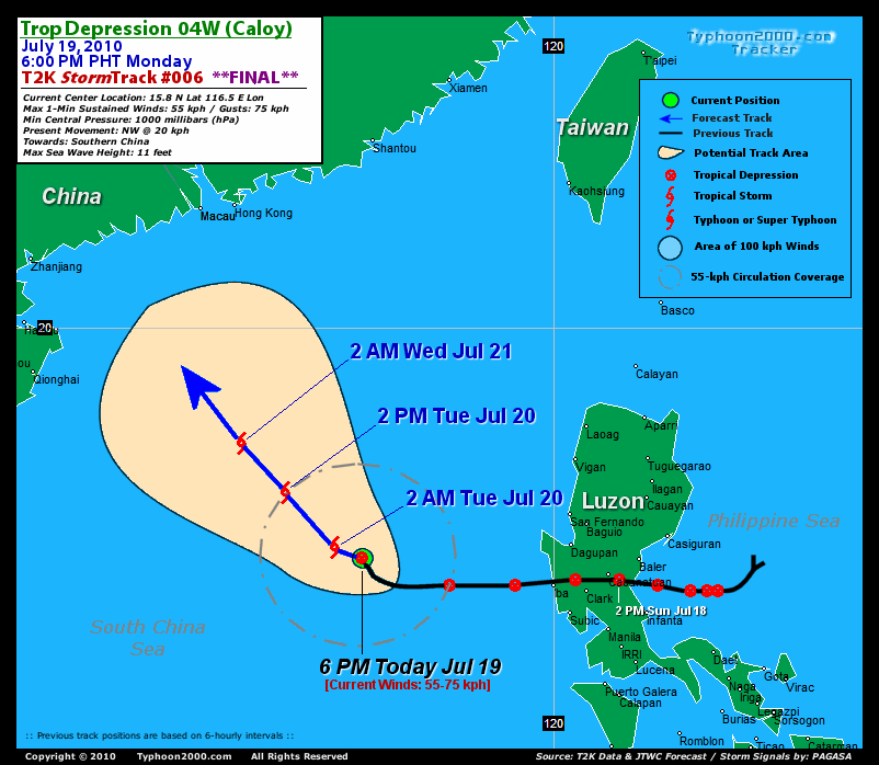
Current Storm Information + Forecast Outlook: 04W is expected to continue moving NW-ward and will intensify into a Tropical Storm tonight [2AM JUL 20: 16.0N 116.0E @ 65kph]. It will eventually move NNW across the South China Sea towards Western Guangdong, reaching peak strength of 100 kph on Wednesday [2PM JUL 21: 19.1N 113.6E @ 100kph]. The 3 to 4-day Long-Range Forecast shows 04W making landfall west of Macau Thursday afternoon [2PM JUL 22: 21.6N 112.3E @ 100kph]. It shall then dissipate as it moves overland across mainland China late Thursday until Friday [2PM JUL 23: 24.3N 111.4E @ 35kph].
Time/Date: 6:00 PM PhT Mon Jul 19 2010
Location of Center: 15.8º N Lat 116.5º E Lon
Distance 1: 380 km (205 nm) WNW of Iba, Zambales
Distance 2: 405 km (220 nm) WSW of Dagupan City
Distance 3: 420 km (227 nm) WNW of Subic Bay/Olongapo
Distance 4: 510 km (275 nm) WNW of Metro Manila
Distance 5: 750 km (405 nm) SSE of Hong Kong
MaxWinds (1-min avg): 55 kph (30 kts) near the center
Peak Wind Gusts: 75 kph (40 kts)
6-hr Rain Amounts (near the center): 225 mm [Heavy]
Minimum Central Pressure: 1000 millibars (hPa)
Saffir-Simpson Typhoon Scale: Tropical Depression
Present Movement: NW @ 20 kph (11 kts)
Towards: Southern China
Size (in Diameter): 300 km (160 nm) / Small
Max Sea Wave Height (near center): 11 ft (3.3 m)
Coastal Storm Surge Height: 0 feet [0 m]
T2K Final TrackMap #006 (for Public): 6 PM PhT Mon Jul 19
+ Effects & Hazards: TD 04W's (CALOY) circulation continues to become better organized while over the South China Sea. Its outer (feeder) bands is no longer affecting Zambales & Western Pangasinan. 6-hr total rainfall amounts of 5 up to 100 mm (light, moderate to heavy rain) can be expected along the outer and inner rainbands...
+ Current ITCZ Intensity: MODERATE >> Sunny to mostly cloudy skies with scattered to widespread afternoon or evening rains w/ strong thunderstorms can be expected along the following affected areas: REST OF THE PHILIPPINES. Possible landslides, mudslides, mudflows (lahars) and life-threatening flash floods are likely to occur along steep mountain/volcanic slopes, river banks, low-lying & flood-prone areas of the affected areas.
[Important Note: Please keep in mind that the above forecast outlook, effects, current monsoon intensity, & tropical cyclone watch changes every 6 to 12 hrs!]![]()
External Links for 04W (CALOY)
View NOAA-CIRA's Latest Wind Analysis
JTWC Latest Tracking Chart: wp0410.gif
TSR Wind Probabilities: Current to 96 hrs Ahead
Zoomed Satellite Pic: NOAA's Near Real-Time
Wunderground Animation: 6-12 hr. GIF Loop
*ANIMATED MULTISPECTRAL SATELLITE IMAGERY
INDICATES THAT DEEP CONVECTION HAS WANED DIURNALLY WITH DISORGANIZED
BURSTS OF DEEP CONVECTION OVER THE LOW-LEVEL CIRCULATION CENTER
(LLCC). ANIMATED WATER VAPOR IMAGERY CONTINUES TO DEPICT GOOD
OUTFLOW WITH POLEWARD OUTFLOW ENHANCED BY UPPER-LEVEL LOWS NEAR
TAIWAN AND OKINAWA. THERE IS FAIR CONFIDENCE IN THE CURRENT POSITION
BASED ON A 190128Z ASCAT IMAGE INDICATING AN ELONGATED BUT DEFINED
LLCC. THE CURRENT INTENSITY OF 30 KNOTS IS BASED ON THE ASCAT DATA
ALONG WITH DVORAK ESTIMATES RANGING FROM 25 TO 30 KNOTS FROM PGTW,
KNES AND RJTD. TD 04W IS TRACKING ALONG THE SOUTHWESTERN PERIPHERY
OF THE LOW- TO MID-LEVEL SUBTROPICAL RIDGE WHICH EXTENDS OVER
TAIWAN. TD 04W IS FORECAST TO TURN NORTHWESTWARD TO NORTH-
NORTHWESTWARD IN THE NEXT 12 TO 24 HOURS, AND IS EXPECTED TO MAKE
LANDFALL NEAR HONG KONG. THERE IS QUITE A BIT OF UNCERTAINTY IN
EXACT TRACK AND LANDFALL LOCATION WITH ABOUT A 280 NM SPREAD IN
MODEL GUIDANCE AT TAU 72. JGSM IS THE WESTERN-MOST OUTLIER AND
INDICATES LANDFALL NORTH OF HAINAN ISLAND WHILE GFS IS THE EASTERN-
MOST OUTLIER AND SHOWS LANDFALL JUST EAST OF HONG KONG. THE OFFICIAL
FORECAST IS POSITIONED SLIGHTLY LEFT OF THE MODEL CONSENSUS TO
ACCOUNT FOR THE EXCESSIVE NORTHWARD TRACK OF GFS. THE SYSTEM IS
FORECAST TO INTENSIFY SLOWLY THROUGH TAU 24 AS IT CONSOLIDATES THEN
SHOULD REACH A PEAK INTENSITY OF 55 KNOTS BY TAU 48....(more)
RECENT TYPHOON2000.

________________________

> Image source: NOAA SATELLITE CENTER
RECENT WUNDERGROUND SATELLITE ANIMATION:
> Image source: Wunderground.
> Image source: NOAA Satellite & Information Service (http://www.ssd.
>> To know the meteorological terminologies and acronyms used on this update visit the ff:
http://typhoon2000.
http://www.nhc.
http://www.srh.
http://www.srh.
http://www.nhc.
____________
> http://www.typhoon2
> http://www.maybagyo
Copyright © 2010 Typhoon2000.
No comments:
Post a Comment