
for Monday, 12 July 2010 [6:36 AM PhT]

<<<Typhoon2000.
Get the latest 6-Hrly SMS Storm Alerts on BASYANG!
For more details: Text T2K TYPHOON to
2800 (Globe/TM) | 216 (Smart/TNT) | 2288 (Sun)
*only P2.50 (Smart/Globe) / P2.00 (Sun) per msg received.
powered by: Synermaxx
Typhoon2000 (T2K) NEWS (Mon July 12 2010):
Now issuing 6-hrly advisories (except 12 AM PhT) on TS CONSON (BASYANG). Meanwhile, those who are automatically subscribed to the T2K ON service of SMART/TNT, we are sorry to announce - that service is currently OFFLINE. Smart tech guys are fixing the problem. For the meantime, kindly use the ON-DEMAND SMS by texting T2K TYPHOON to get the latest info on this approaching storm.
CONSON (BASYANG) MAX WIND SPEED PER AGENCY:
+ USA (JTWC/1-min avg): 85 km/hr
+ Japan (JMA/10-min avg): 65 km/hr
+ Philippines (PAGASA/10-min avg): 55 km/hr
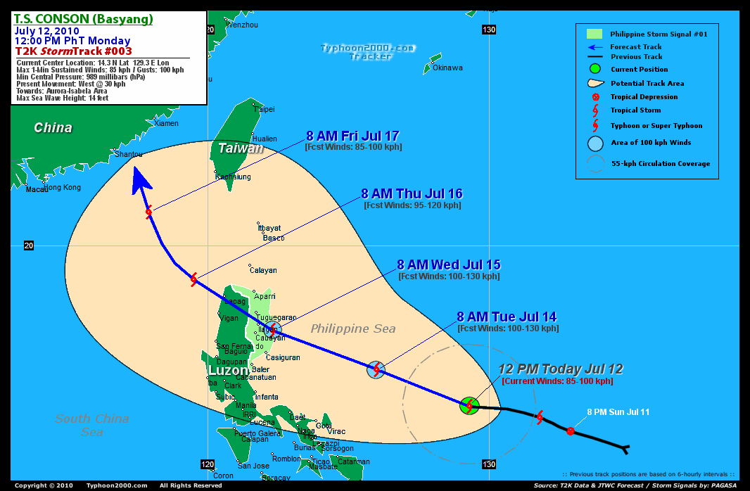
TROPICAL STORM CONSON [BASYANG/03W/
T2K PUBLIC ADVISORY NUMBER 003
12:00 PM PhT (04:00 GMT) Mon 12 July 2010
Source: T2K Analysis/JTWC Warning #003
View: Advisory Archives (2004-2010)
*Residents and visitors along Bicol Region and Luzon should closely monitor the progress of CONSON (BASYANG).
*Do not use this for life or death decision. This advisory is intended for additional information purposes only. Kindly refer to your country's official weather agency for local warnings, advisories & bulletins.
Current Storm Information
Time/Date: 12:00 PM PhT Mon Jul 12 2010
Location of Center: 14.3º N Lat 129.3º E Lon
Distance 1: 545 km (295 nm) ENE of Virac, Catanduanes
Distance 2: 595 km (320 nm) ENE of Gota, Caramoan
Distance 3: 620 km (335 nm) ENE of Legazpi City
Distance 4: 665 km (360 nm) ENE of Metro Naga/CWC
Distance 5: 690 km (373 nm) East of Daet, Cam. Norte
Distance 6: 800 km (430 nm) ESE of Casiguran, Aurora
Distance 7: 820 km (443 nm) East of Infanta, Quezon
Distance 8: 885 km (478 nm) East of Metro Manila
MaxWinds (1-min avg): 85 kph (45 kts) near the center
Peak Wind Gusts: 100 kph (55 kts)
6-hr Rain Amounts (near the center): 110 mm [Moderate]
Minimum Central Pressure: 989 millibars (hPa)
Saffir-Simpson Typhoon Scale: TS
Present Movement: West @ 30 kph (16 kts)
Towards: Northern Luzon
Size (in Diameter): 330 km (180 nm) / Small
Max Sea Wave Height (near center): 14 ft (4.2 m)
Coastal Storm Surge Height: <4 feet [<1.2 m]
T2K TrackMap #003 (for Public): 12 PM PhT Mon Jul 12
+ Forecast Outlook: CONSON (BASYANG) is expected to maintain its WNW track through the next 2 to 3 days and intensify as it moves towards Northern Luzon, almost becoming a Typhoon w/ forecast winds of 110 kph tomorrow evening [8PM JUL 13: 16.3N 124.1E]. It will then make landfall somewhere between Northern Aurora and Southern Isabela Wednesday morning [8 AM JUL 14: 17.0N 122.3E], and then cross Northern Luzon. CONSON will lose strength upon traversing the mountainous terrain of the Sierra Madres and the Cordilleras on Wednesday noon until the evening. The 3 to 5-Day Long-Range Forecast shows the system exiting Ilocos Provinces by Thursday [8AM JUL 15: 18.8N 119.5E] and will turn more to the NW across the South China Sea on Friday...approachin
[Important Note: Please keep in mind that the above forecast outlook, effects, current monsoon intensity, & tropical cyclone watch changes every 6 to 12 hrs!]
PAGASA's Philippine Storm Warnings Signals
PHILIPPINE STORM WARNING SIGNAL # ONE (1)

In Effect: CAGAYAN, ISABELA AND AURORA.
The above areas will have rains and winds of not more than 60 kph can be expected beginning tomorrow. Coastal waters will be moderate to rough.
Residents living in low-lying and mountainous areas under Public Storm Warning Signal Number 1 are alerted against flashfloods, mudflows, mudslides and landslides..
External Links for TS CONSON (BASYANG)
View NOAA-CIRA's Latest Wind Analysis
JTWC Latest Tracking Chart: wp0310.gif
Multi-Agency Forecast TrackMap: 12 PM Mon Jul 12
TSR Wind Probabilities: Current to 24 hrs Ahead
Zoomed Satellite Pic: NOAA's Near Real-Time
Wunderground Animation: 6-12 hr. GIF Loop
8 PM (12 GMT) 12 JULY: 14.9N 128.4E / 95-120 KPH (TS) / WNW @ 22 KPH
8 AM (00 GMT) 13 JULY: 15.6N 126.0E / 100-130 KPH (TS) / WNW @ 19 KPH
8 AM (00 GMT) 14 JULY: 17.0N 122.3E / 100-130 KPH (TS) / NW @ 15 KPH
REMARKS (for Meteorologists)
*TS 03W HAS TRACKED WEST-NORTHWESTWARD AT 12 KNOTS ALONG THE
SOUTHWESTERN PERIPHERY OF A MID-LEVEL SUBTROPICAL RIDGE (STR) OVER
THE PAST SIX HOURS. ANIMATED MULTISPECTRAL SATELLITE IMAGERY
INDICATES INCREASED CONVECTIVE ORGANIZATION. A 85 GHZ TRMM
MICROWAVE IMAGE DEPICTS TIGHTLY CURVED BANDING WRAPPING INTO A
MICROWAVE EYE FEATURE, CONFIRMING THAT THE SYSTEM IS UNDERGOING A
PERIOD OF RAPID INTENSIFICATION ASSOCIATED WITH LOW VERTICAL WIND
SHEAR (VWS), HIGH SST (>30 DEGREES CELSIUS), AND HIGH OCEAN HEAT
CONTENT (OHC) ALONG THE TRACK. THE CURRENT INTENSITITY IS BASED ON A
DVORAK ESTIMATE OF 45 KNOTS FROM PGTW. UPPER LEVEL ANALYSIS
INDICATES THAT THE SYSTEM HAS GOOD RADIAL OUTFLOW...(more)
>> CONSON, meaning: A historical place. Name contributed by: Vietnam.
____________
PAGASA CURRENT POSITION, MOVEMENT AND INTENSITY (10-min. ave.):
> 10 AM (02 GMT) MON 12 JULY: 14.4N 130.4E / WNW @ 22 kph / 65 kph
:: For the complete PAGASA bulletin, kindly visit their website at:
http://www.pagasa.dost.gov.ph/wb/tcupdate.shtml
_______________________________________________________________________________________________________________________________________
:: For the complete PAGASA bulletin, kindly visit their website at:
http://www.pagasa.
____________
RECENT TYPHOON2000.
________________________
RECENT MTSAT-1R "DAY & NIGHT VISION" SATELLITE IMAGE:

> Image source: NOAA SATELLITE CENTER
RECENT WUNDERGROUND SATELLITE ANIMATION:
***WARNING!!! THIS SATELLITE ANIMATION IS NOT YET ALIGNED WITH THE LAND FEATURES (Check the aligned photo above).***

> Image source: Wunderground.com (http://www.wunderground.com/ ) ____________________________________________________________________________________________________________________
> Image source: NOAA SATELLITE CENTER
____________________________________________________________________________________________________________________
RECENT WUNDERGROUND SATELLITE ANIMATION:
***WARNING!!
> Image source: Wunderground.
LATEST 6 HR. TOTAL RAINFALL AMOUNTS / ENSEMBLE TROPICAL RAINFALL POTENTIAL (eTRaP):

> Image source: NOAA Satellite & Information Service (http://www.ssd.noaa.gov/PS/TROP/etrap.html )____________________________________________________________________________________________________________________
> Image source: NOAA Satellite & Information Service (http://www.ssd.
NOTE:
* - JTWC commentary remarks (for Meteorologists) from their latest warning.
__________________________________________________________________________________________
>> To know the meteorological terminologies and acronyms used on this update visit the ff:
http://typhoon2000.ph/tcterm.htm
http://www.nhc.noaa.gov/aboutgloss.shtml
http://www.srh.noaa.gov/oun/severewx/glossary.php
http://www.srh.weather.gov/fwd/glossarynation.html
http://www.nhc.noaa.gov/acronyms.shtml
__________________________________________________________________________________________
For the complete details on TS CONSON(BASYANG)...go visit our website @:
> http://www.typhoon2000.com
> http://www.maybagyo.com
>> To know the meteorological terminologies and acronyms used on this update visit the ff:
http://typhoon2000.
http://www.nhc.
http://www.srh.
http://www.srh.
http://www.nhc.
____________
>
> http://www.maybagyo
Copyright © 2010 Typhoon2000.
__._,_.___
MARKETPLACE
.
__,_._,___

No comments:
Post a Comment