
for Monday, 12 July 2010 [7:09 PM PhT]

<<<Typhoon2000.
Get the latest 6-Hrly SMS Storm Alerts on BASYANG!
For more details: Text T2K TYPHOON to
2800 (Globe/TM) | 216 (Smart/TNT) | 2288 (Sun)
*only P2.50 (Smart/Globe) / P2.00 (Sun) per msg received.
powered by: Synermaxx
Typhoon2000 (T2K) NEWS (Mon July 12 2010):
Now issuing 6-hrly advisories (except 12 AM PhT) on TS CONSON (BASYANG). Meanwhile, those who are automatically subscribed to the T2K ON service of SMART/TNT, we are sorry to announce - that service is currently OFFLINE. Smart tech guys are fixing the problem. For the meantime, kindly use the ON-DEMAND SMS by texting T2K TYPHOON to get the latest info on this approaching storm.
CONSON (BASYANG) MAX WIND SPEED PER AGENCY:
+ USA (JTWC/1-min avg): 110 km/hr
+ Japan (JMA/10-min avg): 75 km/hr
+ Philippines (PAGASA/10-min avg): 75 km/hr
+ Korea (KMA/10-min avg): 75 km/hr
+ Hong Kong (HKO/10-min avg): 55 km/hr
+ Taiwan (CWB/10-min avg): 85 km/hr
+ Beijing (NMC/2-min avg): 85 kph
TROPICAL STORM CONSON [BASYANG/03W/
T2K EMAIL ADVISORY NUMBER 003
6:00 PM PhT (10:00 GMT) Mon 12 July 2010
Source: T2K Analysis/JTWC Warning #004
View: Advisory Archives (2004-2010)
*Residents and visitors along Samar, Bicol Region and Luzon should closely monitor the progress of CONSON (BASYANG).
*Do not use this for life or death decision. This advisory is intended for additional information purposes only. Kindly refer to your country's official weather agency for local warnings, advisories & bulletins.
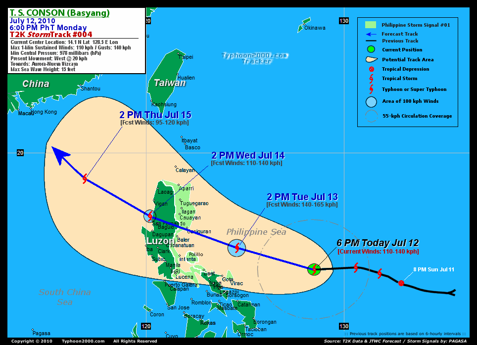
Current Storm Information
Time/Date: 6:00 PM PhT Mon Jul 12 2010
Location of Center: 14.1º N Lat 128.5º E Lon
Distance 1: 455 km (245 nm) ENE of Virac, Catanduanes
Distance 2: 510 km (275 nm) ENE of Gota, Caramoan
Distance 3: 530 km (285 nm) ENE of Legazpi City
Distance 4: 575 km (310 nm) ENE of Metro Naga/CWC
Distance 5: 605 km (327 nm) East of Daet, Cam. Norte
Distance 6: 725 km (392 nm) SE of Casiguran, Aurora
Distance 7: 735 km (397 nm) ESE of Infanta, Quezon
Distance 8: 800 km (432 nm) ESE of Metro Manila
MaxWinds (1-min avg): 110 kph (60 kts) near the center
Peak Wind Gusts: 140 kph (75 kts)
6-hr Rain Amounts (near the center): 150 mm [Heavy]
Minimum Central Pressure: 978 millibars (hPa)
Saffir-Simpson Typhoon Scale: TS
Present Movement: West @ 20 kph (11 kts)
Towards: Aurora-Nueva Vizcaya
Size (in Diameter): 330 km (180 nm) / Small
Max Sea Wave Height (near center): 15 ft (4.5 m)
Coastal Storm Surge Height: <4 feet [<1.2 m]
T2K TrackMap #004 (for Public): 6 PM PhT Mon Jul 12
+ Forecast Outlook: CONSON (BASYANG) is expected to resume its WNW track through the next 2 days and intensify into a Category 1 Typhoon while moving towards Central & Northern Luzon. It shall reach its forecast peak winds of 140 kph by tomorrow afternoon [2PM JUL 13: 15.2N 124.6E] and pass more or less 200 km. to the north of Naga City between 5-8 PM tomorrow evening. CONSON shall make landfall somewhere between Baler and Casiguran in Aurora early Wednesday morning [2 AM JUL 14: 15.9N 122.4E], before crossing Central and Northern Luzon. It will be downgraded into a Tropical Storm upon traversing the mountainous terrain of Nueva Vizcaya & Benguet on Wednesday morning until the afternoon, and will move out into the South China Sea via La Union [2PM JUL 14: 16.8N 120.2E]. The 3 to 5-Day Long-Range Forecast shows the system turning more to the NW to NNW Thursday afternoon while over the South China Sea [2PM JUL 15: 18.7N 116.9E]. CONSON shall make its second landfall on Saturday along Southern China or in the vicinity of Hong Kong [2PM JUL 17: 23.2N 114.2E]. *Alternate Forecast Scenario (AFS): There is a possibility that CONSON will continue tracking Westward and pass more or less 100 km. to the north of Naga tomorrow evening, and traverse Central Luzon via Infanta or Baler -- if the strong, steering High Pressure Ridge which extends east of Taiwan will not weaken. Please be reminded that the Forecast Outlook changes every 6 hours, so a turn to the left or right of its future track and other possibilities must be considered.
+ Effects & Hazards: CONSON's (BASYANG) small and compact circulation continues to improve while it remains over the Philippine Sea...its initial effects & hazards of this storm will start to be felt across Eastern Bicol Region beginning tomorrow morning. 6-hr total rainfall amounts of 5 up to 100 mm (light to moderate rain) can be expected along the outer and inner rainbands...
[Important Note: Please keep in mind that the above forecast outlook, effects, current monsoon intensity, & tropical cyclone watch changes every 6 to 12 hrs!]
PAGASA's Philippine Storm Warnings Signals
PHILIPPINE STORM WARNING SIGNAL # ONE (1)

In Effect: CAGAYAN, ISABELA, AURORA, QUEZON, POLILLO ISLAND, CAMARINES NORTE, AND CATANDUANES.
The above areas will have rains and winds of not more than 60 kph can be expected beginning tomorrow. Coastal waters will be moderate to rough.
Residents living in low-lying and mountainous areas under Public Storm Warning Signal Number 1 are alerted against flashfloods, mudflows, mudslides and landslides..
External Links for TS CONSON (BASYANG)
View NOAA-CIRA's Latest Wind Analysis
JTWC Latest Tracking Chart: wp0310.gif
Multi-Agency Forecast TrackMap: 4 PM Mon Jul 12
TSR Wind Probabilities: Current to 24 hrs Ahead
Zoomed Satellite Pic: NOAA's Near Real-Time
Wunderground Animation: 6-12 hr. GIF Loop
2 AM (18 GMT) 13 JULY: 14.6N 126.8E / 120-150 KPH (TY-Cat 1) / WNW @ 20 KPH
2 PM (06 GMT) 13 JULY: 15.2N 124.6E / 140-165 KPH (TY-Cat 1) / WNW @ 20 KPH
2 PM (06 GMT) 14 JULY: 16.8N 120.2E / 110-140 KPH (TS) / WNW @ 17 KPH
REMARKS (for Meteorologists)
*ANIMATED MULTISPECTRAL SATELLITE IMAGERY SHOWS VERY TIGHT CONVECTIVE
WRAPPING AND GOOD RADIAL OUTFLOW WHILE ANIMATED WATER VAPOR IMAGERY
INDICATES THE WESTWARD-PUSHING TROPICAL UPPER TROPOSPHERIC TROUGH
(TUTT) CELL CONTINUES TO INDUCE A STRONG POLEWARD TUG. CONSEQUENTLY,
THE CURRENT INTENSITY OF 60 KNOTS IS SLIGHTLY HIGHER THAN THE DVORAK
ESTIMATES FROM PGTW AND KNES OF T3.5 IN CONSIDERATION OF THE VERY
SMALL SIZE OF THE SYSTEM. THOUGH TC 03W HAS JOGGED SLIGHTLY SOUTH
OF WEST OVER THE PAST SIX HOURS, THE SYSTEM IS STILL EXPECTED TO TRACK
NORTHWESTWARD ALONG THE SUBTROPICAL RIDGE (STR) THROUGH LUZON
AND INTO THE SOUTH CHINA SEA. BY TAU 72, A LONG-WAVE TROUGH IS EXPEC-
TED TO WEAKEN THE STR AND ENABLE THE STORM TO TURN MORE NORTH-
WARD. AT THE SAME TIME, THE SYSTEM IS EXPECTED TO GRADUALLY WEAKEN
AS IT ENCOUNTERS INCREASINGLY UNFAVORABLE VERTICAL WIND
SHEAR....(more)
>> CONSON, meaning: A historical place. Name contributed by: Vietnam.
____________
PAGASA CURRENT POSITION, MOVEMENT AND INTENSITY (10-min. ave.):
> 4 PM (08 GMT) MON 12 JULY: 14.3N 128.7E / WNW @ 22 kph / 75 kph
:: For the complete PAGASA bulletin, kindly visit their website at:
http://www.pagasa.dost.gov.ph/wb/tcupdate.shtml
_______________________________________________________________________________________________________________________________________
:: For the complete PAGASA bulletin, kindly visit their website at:
http://www.pagasa.
____________
RECENT TYPHOON2000.
________________________
RECENT MTSAT-1R "DAY & NIGHT VISION" SATELLITE IMAGE:

> Image source: NOAA SATELLITE CENTER
RECENT WUNDERGROUND SATELLITE ANIMATION:
***WARNING!!! THIS SATELLITE ANIMATION IS NOT YET ALIGNED WITH THE LAND FEATURES (Check the aligned photo above).***

> Image source: Wunderground.com (http://www.wunderground.com/ ) ____________________________________________________________________________________________________________________
> Image source: NOAA SATELLITE CENTER
____________________________________________________________________________________________________________________
RECENT WUNDERGROUND SATELLITE ANIMATION:
***WARNING!!
> Image source: Wunderground.
LATEST 6 HR. TOTAL RAINFALL AMOUNTS / ENSEMBLE TROPICAL RAINFALL POTENTIAL (eTRaP):

> Image source: NOAA Satellite & Information Service (http://www.ssd.noaa.gov/PS/TROP/etrap.html )____________________________________________________________________________________________________________________
> Image source: NOAA Satellite & Information Service (http://www.ssd.
NOTE:
* - JTWC commentary remarks (for Meteorologists) from their latest warning.
__________________________________________________________________________________________
>> To know the meteorological terminologies and acronyms used on this update visit the ff:
http://typhoon2000.ph/tcterm.htm
http://www.nhc.noaa.gov/aboutgloss.shtml
http://www.srh.noaa.gov/oun/severewx/glossary.php
http://www.srh.weather.gov/fwd/glossarynation.html
http://www.nhc.noaa.gov/acronyms.shtml
__________________________________________________________________________________________
For the complete details on TS CONSON (BASYANG)...go visit our website @:
> http://www.typhoon2000.com
> http://www.maybagyo.com
>> To know the meteorological terminologies and acronyms used on this update visit the ff:
http://typhoon2000.
http://www.nhc.
http://www.srh.
http://www.srh.
http://www.nhc.
____________
>
> http://www.maybagyo
Copyright © 2010 Typhoon2000.
__._,_.___
MARKETPLACE
.
__,_._,___

No comments:
Post a Comment