
for Thursday, 15 July 2010 [6:58 PM PhT]

<<<Typhoon2000.
Get the latest 6-Hrly SMS Storm Alerts on BASYANG!
For more details: Text T2K TYPHOON to
2800 (Globe/TM) | 216 (Smart/TNT) | 2288 (Sun)
*only P2.50 (Smart/Globe) / P2.00 (Sun) per msg received.
powered by: Synermaxx
Typhoon2000 (T2K) NEWS (Thu July 15 2010):
Currently issuing 6-hrly updates (except 12 AM PhT) on TS CONSON (BASYANG).
CONSON (BASYANG) MAX WIND SPEED PER AGENCY:
+ USA (JTWC/1-min avg): 95 km/hr
+ Japan (JMA/10-min avg): 85 km/hr
+ Philippines (PAGASA/10-min avg): 85 km/hr
+ Korea (KMA/10-min avg): 80 km/hr
+ Hong Kong (HKO/10-min avg): 95 km/hr
+ Taiwan (CWB/10-min avg): 85 km/hr
+ Beijing (NMC/2-min avg): 85 kph
TROPICAL STORM CONSON [BASYANG/03W/
T2K EMAIL ADVISORY NUMBER 011
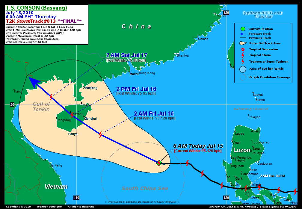
6:00 AM PhT (22:00 GMT) Thu 15 July 2010
Source: T2K Analysis/JTWC Warning #014
View: Advisory Archives (2004-2010)
*Residents and visitors along Hainan Island & Southern China should closely monitor the progress of CONSON (BASYANG).
*Do not use this for life or death decision. This advisory is intended for additional information purposes only. Kindly refer to your country's official weather agency for local warnings, advisories & bulletins.
Current Storm Information
Time/Date: 6:00 AM PhT Thu Jul 15 2010
Location of Center: 16.1º N Lat 115.5º E Lon
Distance 1: 515 km (278 nm) West of Dagupan City
Distance 2: 545 km (295 nm) WSW of Baguio City
Distance 3: 690 km (373 nm) SSE of Hong Kong
Distance 4: 705 km (380 nm) SSE of Macau
Distance 5: 765 km (413 nm) SSE of Hong Kong
MaxWinds (1-min avg): 95 kph (50 kts) near the center
Peak Wind Gusts: 120 kph (85 kts)
6-hr Rain Amounts (near the center): 180 mm [Moderate-Heavy]
Minimum Central Pressure: 985 millibars (hPa)
Saffir-Simpson Typhoon Scale: TS
Present Movement: West @ 22 kph (12 kts)
Towards: Hainan-Southern China
Size (in Diameter): 370 km (200 nm) / Average
Max Sea Wave Height (near center): 18 ft (4.5 m)
Coastal Storm Surge Height: 0-4 feet [0-1.2 m]
T2K Final TrackMap #012 (for Public): 6 AM PhT Thu Jul 15
+ Forecast Outlook: CONSON (BASYANG) is expected to resume tracking WNW to NW-ward across the South China Sea for the next 3 days...will now make landfall over Hainan Island (China) tomorrow morning approx. 8 AM [2PM JUL 16: 19.3N 109.7E - 75kph]. The 2 to 3-Day Medium-Range Forecast shows the system entering the Gulf of Tonkin early Saturday morning [2AM JUL 17: 20.5N 108.3E - 75kph] and will make landfall along the Vietnam-China border around Saturday noontime. It shall dissipate rapidly overland on Sunday [2AM JUL 18: 22.5N 106.4E - 35kph]. Please be reminded that the Forecast Outlook changes every 6 hours, so a turn to the left or right of its future track and other possibilities must be considered.
+ Effects & Hazards: CONSON's (BASYANG) rain bands is now well over the South China Sea, no longer affecting Luzon & Palawan in the Philippines. Its outer rain bands is expected to reach Eastern Vietnam later today, and over Hainan tonight. 6-hr total rainfall amounts of 5 up to 100 mm (light, moderate to heavy rain) can be expected along the outer and inner rainbands...
[Important Note: Please keep in mind that the above forecast outlook, effects, current monsoon intensity, & tropical cyclone watch changes every 6 to 12 hrs!]
PAGASA's Philippine Storm Warnings Signals
PHILIPPINE STORM WARNING SIGNAL # ONE (1)

Now lowered: PANGASINAN, BATAAN, AND ZAMBALES.
External Links for TY CONSON (BASYANG)
View NOAA-CIRA's Latest Wind Analysis
JTWC Latest Tracking Chart: wp0310.gif
Multi-Agency Forecast TrackMap: 5 AM Thu Jul 15
TSR Wind Probabilities: Current to 72 hrs Ahead
NASA-JAXA TMI Page: Latest Rainrate 01
EORC-JAXA TRMM Page: Latest Rainrate 02
Zoomed Satellite Pic: NOAA's Near Real-Time
Wunderground Animation: 6-12 hr. GIF Loop
REMARKS (for Meteorologists): 2AM (18 GMT) THU 15 JULY POSITION: 16.1N 116.1E.
*ANIMATED INFRARED IMAGERY
INDICATES FLARING CONVECTION OVER THE SYSTEM CENTER DUE TO DIURNAL
EFFECTS, HOWEVER, THIS CONVECTION CONTINUES TO BE SHEARED TO THE
SOUTHWEST DUE TO UPPER LEVEL NORTHEASTERLY FLOW. THERE IS FAIR
CONFIDENCE IN THE POSTION BASED ON A 141751Z 89 GHZ AMSRE MICROWAVE
IMAGE, WHICH ALSO SHOWS TIGHTLY CURVED BANDING WRAPPING INTO THE LOW
LEVEL CIRCULATION CENTER. THE CURRENT INTENSITY IS ASSESSED
AT 50 KNOTS BASED ON DVORAK CURRENT INTENSITY VALUES RANGING FROM 45
TO 55 KNOTS. UPPER LEVEL ANALYSIS INDICATES THAT TS 03W IS TRACKING
ALONG THE SOUTHERN PERIPHERY OF THE LOW- TO MID-LEVEL SUBTROPICAL
RIDGE ENTRENCHED OVER CHINA AND WILL ENCOUNTER INCREASED (>30 KNOTS)
NORTHEASTERLY VERTICAL WIND SHEAR AS IT CONTINUEES TRACKING
WESTWARD. THIS FORECAST TRACKS TS 03W SLIGHTLY MORE TO THE WEST THAN
THE PREVIOUS FORECAST, BASED ON THE MORE ZONAL ORIENTATION OF THE
STEERING RIDGE THAN PREVIOUSLY EXPECTED. TS 03W IS FORECAST TO
WEAKEN NEAR TAU 36 AS IT CROSSES OVER HAINAN AND IS FORECAST TO
DISIPATE AS A SIGNIFICANT TROPICAL CYCLONE OVER NORTHERN VIETNAM BY
TAU 72. NUMERICAL MODEL GUIDANCE IS TIGHTLY CLUSTERED. THIS FORECAST
IS IN GOOD AGREEMENT WITH MODEL CONSENSUS THROUGH TAU 48, BUT
DEVIATES SLIGHTLY TO THE WEST OF THE CONSENSUS THEREAFTER IN
ANTICIPATION OF A MORE ZONAL STEERING PATTERN...(more)
>> CONSON, meaning: A historical place. Name contributed by: Vietnam.
____________*ANIMATED INFRARED IMAGERY
INDICATES FLARING CONVECTION OVER THE SYSTEM CENTER DUE TO DIURNAL
EFFECTS, HOWEVER, THIS CONVECTION CONTINUES TO BE SHEARED TO THE
SOUTHWEST DUE TO UPPER LEVEL NORTHEASTERLY FLOW. THERE IS FAIR
CONFIDENCE IN THE POSTION BASED ON A 141751Z 89 GHZ AMSRE MICROWAVE
IMAGE, WHICH ALSO SHOWS TIGHTLY CURVED BANDING WRAPPING INTO THE LOW
LEVEL CIRCULATION CENTER. THE CURRENT INTENSITY IS ASSESSED
AT 50 KNOTS BASED ON DVORAK CURRENT INTENSITY VALUES RANGING FROM 45
TO 55 KNOTS. UPPER LEVEL ANALYSIS INDICATES THAT TS 03W IS TRACKING
ALONG THE SOUTHERN PERIPHERY OF THE LOW- TO MID-LEVEL SUBTROPICAL
RIDGE ENTRENCHED OVER CHINA AND WILL ENCOUNTER INCREASED (>30 KNOTS)
NORTHEASTERLY VERTICAL WIND SHEAR AS IT CONTINUEES TRACKING
WESTWARD. THIS FORECAST TRACKS TS 03W SLIGHTLY MORE TO THE WEST THAN
THE PREVIOUS FORECAST, BASED ON THE MORE ZONAL ORIENTATION OF THE
STEERING RIDGE THAN PREVIOUSLY EXPECTED. TS 03W IS FORECAST TO
WEAKEN NEAR TAU 36 AS IT CROSSES OVER HAINAN AND IS FORECAST TO
DISIPATE AS A SIGNIFICANT TROPICAL CYCLONE OVER NORTHERN VIETNAM BY
TAU 72. NUMERICAL MODEL GUIDANCE IS TIGHTLY CLUSTERED. THIS FORECAST
IS IN GOOD AGREEMENT WITH MODEL CONSENSUS THROUGH TAU 48, BUT
DEVIATES SLIGHTLY TO THE WEST OF THE CONSENSUS THEREAFTER IN
ANTICIPATION OF A MORE ZONAL STEERING PATTERN...(more)
>> CONSON, meaning: A historical place. Name contributed by: Vietnam.
RECENT TYPHOON2000.
________________________
RECENT MTSAT-1R "DAY & NIGHT VISION" SATELLITE IMAGE:

> Image source: NOAA SATELLITE CENTER
RECENT WUNDERGROUND SATELLITE ANIMATION:

> Image source: Wunderground.com (http://www.wunderground.com/ ) ____________________________________________________________________________________________________________________
> Image source: NOAA SATELLITE CENTER
____________________________________________________________________________________________________________________
RECENT WUNDERGROUND SATELLITE ANIMATION:
> Image source: Wunderground.
LATEST 6 HR. TOTAL RAINFALL AMOUNTS / ENSEMBLE TROPICAL RAINFALL POTENTIAL (eTRaP):

> Image source: NOAA Satellite & Information Service (http://www.ssd.noaa.gov/PS/TROP/etrap.html )____________________________________________________________________________________________________________________
> Image source: NOAA Satellite & Information Service (http://www.ssd.
NOTE:
* - JTWC commentary remarks (for Meteorologists) from their latest warning.
__________________________________________________________________________________________
>> To know the meteorological terminologies and acronyms used on this update visit the ff:
http://typhoon2000.ph/tcterm.htm
http://www.nhc.noaa.gov/aboutgloss.shtml
http://www.srh.noaa.gov/oun/severewx/glossary.php
http://www.srh.weather.gov/fwd/glossarynation.html
http://www.nhc.noaa.gov/acronyms.shtml
__________________________________________________________________________________________
For the complete details on TY CONSON (BASYANG)...go visit our website @:
> http://www.typhoon2000.com
> http://www.maybagyo.com
>> To know the meteorological terminologies and acronyms used on this update visit the ff:
http://typhoon2000.
http://www.nhc.
http://www.srh.
http://www.srh.
http://www.nhc.
____________
>
> http://www.maybagyo
Copyright © 2010 Typhoon2000.
__._,_.___
MARKETPLACE
.
__,_._,___

No comments:
Post a Comment