
for Sunday, 08 August 2010 [7:15 PM PhT]

<<<Typhoon2000.
Get the latest 6-hrly SMS Storm Alerts on ESTER!
For more details: Text T2K TYPHOON to
2800 (Globe/TM) | 216 (Smart/TNT) | 2288 (Sun)
*only P2.50 (Smart/Globe) / P2.00 (Sun) per msg received.
powered by: Synermaxx
Typhoon2000 (T2K) NEWS (Sat August 07 2010):
Currently issuing 6-hrly advisiories (except 12 AM PhT) on TD 05W (ESTER).
05W (ESTER) MAX WIND SPEED PER AGENCY:
+ USA (JTWC/1-min avg): 45 km/hr
+ Japan (JMA/10-min avg): 55 km/hr
+ Philippines (PAGASA/10-min avg): 65 km/hr
+ Hong Kong (HKO/10-min avg): 55 km/hr
+ Beijing (NMC/2-min avg): 55 kph
TROPICAL DEPRESSION 05W [ESTER]
T2K EMAIL ADVISORY NUMBER 005
6:00 PM PhT (10:00 GMT) Sun 08 August 2010
Source: T2K Analysis/JTWC Warning #002/SatFix
View: Advisory Archives (2004-2010)
*Residents and visitors along Yaeyama-Okinawa-
*Do not use this for life or death decision. This advisory is intended for additional information purposes only. Kindly refer to your country's official weather agency for local warnings, advisories & bulletins.
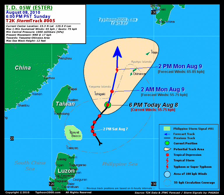
Current Storm Information + Forecast Outlook: 05W is expected to continue tracking NNE to Northward and attain tropical storm status within the next 12 to 24 hours. It will exit the Philippine Area of Responsibility (PAR) early tomorrow morning and pass about 140 km to the West of Okinawa Island by tomorrow afternoon [2PM AUG 09: 26.7N 126.4E @ 65kph]. The system will maintain a straight poleward track, reaching its peak intensity of 75 kph Tuesday afternoon [2PM AUG 10: 30.7N 126.5E @ 75kph] as it moves into the warmer waters of the East China Sea. The 3 to 4-Day Long-Range Forecast Track shows the system weakening as it transitions into an Extratropical Cyclone (ET). It shall then pass very close to the east of Cheju Island and make landfall along the southern coast of South Korea on Wednesday afternoon [2PM AUG 11: 34.4N 127.6E @ 65kph]. 05W shall traverse South Korea Wednesday evening passing in between Taegu and Busan Cities, before moving out into the Sea of Japan Thursday morning. It will completely reach ET status on Thursday afternoon while accelerating eastward across the Sea of Japan [2PM AUG 12: 37.9N 132.6E @ 55kph]. Please be reminded that the Forecast Outlook changes every 6 hours, so a turn to the left or right of its future track and other possibilities must be considered.
Time/Date: 6:00 PM PhT Sun Aug 08 2010
Location of Center: 23.3º N Lat 125.5º E Lon
Distance 1: 175 km (95 nm) SE of Ishigaki, Japan
Distance 2: 400 km (215 nm) ESE of Hualien, Taiwan
Distance 3: 420 km (227 nm) SW of Okinawa, Japan
Distance 4: 430 km (233 nm) ESE of Taipei, Taiwan
Distance 5: 490 km (265 nm) NE of Basco, Batanes
MaxWinds (1-min avg): 55 kph (30 kts) near the center
Peak Wind Gusts: 75 kph (40 kts)
6-hr Rain Amounts (near the center): 200 mm [Heavy]
Minimum Central Pressure: 1000 millibars (hPa)
Saffir-Simpson Typhoon Scale: Tropical Depression
Present Movement: NNE @ 17 kph (09 kts)
Towards: Yaeyama-Ryukyu Islands
Size (in Diameter): 400 km (215 nm) / Average
Max Sea Wave Height (near center): 12 ft (3.6 m)
Coastal Storm Surge Height: 0 feet [0 m]
T2K TrackMap #005 (for Public): 6 PM PhT Sun Aug 08
+ Effects & Hazards: 05W's circulation is now approaching the small island of Ishigaki w/c is a part of the Yaeyama Island Chain. Intense rain and wind convection remains to the South & SW of the depression. Its SW & NE outer bands continues to affect the Batanes Group and now over Okinawa-Ryukyu Islands, where moderate to strong winds of up to 40 kph w/ occasional rains can be expected. The southern convective circulation of 05W is expected to affect Yaeyama Island Chain beginning early tomorrow morning. Click here to view the latest NOAA-CIRA's Wind Analysis. 6-hr total rainfall amounts of 5 up to 100 mm (light to moderate rain) can be expected along the outer and inner rainbands...
+ Current SW Monsoon Intensity: STRONG >> Mostly cloudy skies with passing moderate to heavy rains can be expected along the following affected areas: NORTHERN-CENTRAL-
+ Tropical Cyclone Watch: [Important Note: Please keep in mind that the above forecast outlook, effects, current monsoon intensity, & tropical cyclone watch changes every 6 to 12 hrs!] PHILIPPINE STORM WARNING SIGNAL # ONE (1) The above area will have rains and winds of not more than 60 kph tonight. Coastal waters will be moderate to rough.
Weak Tropical Disturbance 98W (LPA/1003 MB) almost stationary over the South China Sea, close to Hainan Island. Located near lat 18.0N lon 111.0E...or about 1,010 km West of Laoag City...with 1-min maximum sustained winds of 25 kph near the center. This system has a 30% chance of becoming a Tropical Cyclone w/in the next 24 to 48 hours. ![]()
PAGASA's Philippine Storm Warnings Signals

In Effect: BATANES GROUP OF ISLANDS.
Residents living in low-lying and mountainous areas under Public Storm Warning Signal Number 1 are alerted against flashfloods, mudflows, mudslides and landslides.
External Links for TD 05W (ESTER)
View NOAA-CIRA's Latest Wind Analysis
Zoomed Satellite Pic: NOAA's Near Real-Time
JTWC Latest Tracking Chart: wp0510.gif
TSR Wind Probabilities: Current to 96 hrs Ahead
*RECENT ANIMATED MULTISPECTRAL SATELLITE
IMAGERY SHOWS LOW LEVEL BANDING WRAPPING AROUND THE NORTHERN
QUADRANT OF THE LOW LEVEL CIRCULATION CENTER (LLCC) WITH THE
MAJORITY OF THE DEEP CONVECTION STILL REMAINING SOUTH OF THE LLCC
DUE TO AN AREA OF UPPER-LEVEL SUBSIDENCE TO THE NORTH. NEVERTHELESS,
CENTRAL CONVECTION HAS SLIGHTLY INCREASED OVER THE LLCC WHICH HAS
CAUSED LOW CONFIDENCE IN THE INITIAL POSITION. INITIAL INTENSITY WAS
BASED ON PGTW AND KNES DVORAK ESTIMATES OF 25 TO 30 KNOTS.
ENVIRONMENTAL ANALYSIS INDICATES TD 05W IS LOCATED IN AN AREA OF LOW
VERTICAL WIND SHEAR AND GOOD EQUATORWARD OUTFLOW. TD 05W IS
CURRENTLY TRACKING ALONG THE WESTERN PERIPHERY OF A SUBTROPICAL
STEERING RIDGE ANCHORED TO THE EAST OF JAPAN AND IS FORECAST TO
CONTINUE TRACKING NORTHEASTWARD TO NORTHWARD THROUGHOUT THE FORECAST
PERIOD. TD 05W IS EXPECTED TO GRADUALLY INTENSIFY THROUGH TAU 72 AS
IT TRACKS OVER WARM SEA SURFACE TEMPERATURES AND THROUGH AN AREA OF
LOW VERTICAL WIND SHEAR. AFTER TAU 72, TD 05W SHOULD BEGIN TO
INTERACT WITH LAND AS WELL AS THE APPROACHING BAROCLINIC ZONE AND BY
TAU 96 IT IS EXPECTED TO BECOME EXTRATROPICAL. THE NUMERICAL MODEL
GUIDANCE IS IN GENERAL AGREEMENT WITH THIS SCENARIO WITH THE MODELS
DEPICTING VARIOUS DEGREES OF A WESTWARD PUSH BY THE STEERING RIDGE
AROUND TAU 48. CONSEQUENTLY, THE GFDN MODEL TRACKS MORE WESTWARD
TOWARDS SEOUL, SOUTH KOREA WHILE THE ECMWF MODEL DEPICTS A TRACK
CLOSER TO SASEBO, JAPAN. FINALLY, THE GFS TRACKER IS AN OUTLIER TO
THE EAST AS IT SHOWS THE SYSTEM TRACKING TOWARDS OKINAWA, JAPAN
BEFORE SLOWLY TURNING BACK NORTHWESTWARD TOWARDS CHEJU
ISLAND...(more)
RECENT TYPHOON2000 TRACKING CHART:
________________________

> Image source: NOAA SATELLITE CENTER
> Image source: Wunderground.

> Image source: NOAA Satellite & Information Service (http://www.ssd.
>> To know the meteorological terminologies and acronyms used on this update visit the ff:
http://typhoon2000.
http://www.nhc.
http://www.srh.
http://www.srh.
http://www.nhc.
____________
> http://www.typhoon2
> http://www.maybagyo
Copyright © 2010 Typhoon2000.

No comments:
Post a Comment