
for Monday, 18 October 2010 [6:15 AM PhT]![]()

<<<Typhoon2000.com Mobile >>>
Get the latest Hourly SMS Storm Alerts on JUAN!
For more details: Text T2K TYPHOON to
2800 (Globe/TM) | 216 (Smart/TNT) | 2288 (Sun)
*only P2.50 (Smart/Globe) / P2.00 (Sun) per msg received.
powered by: Synermaxx
Typhoon2000 (T2K) NEWS (Monday Oct 18 2010):
Currently issuing hrly web, SMS & email advisories on MEGI (JUAN). The T2K HOURLY POSITION ESTIMATE (NOWCASTING) has started. Go to our mainpage.
MEGI (JUAN) MAX WIND SPEED PER AGENCY:
+ USA (JTWC/1-min avg): 285 km/hr
+ Japan (JMA/10-min avg): 220 km/hr
+ Philippines (PAGASA/10-min avg): 225 km/hr
+ Korea (KMA/10-min avg): 220 km/hr
+ Taiwan (CWB/10-min avg): 215 km/hr
+ Beijing (NMC/2-min avg): 260 km/hr
+ Hong Kong (HKO/10-min avg): 220 km/hr
SUPER TYPHOON MEGI [JUAN/15W/1013]
T2K E-MAIL ADVISORY NUMBER 016
6:00 AM PhT (22:00 GMT) Mon 18 October 2010
Sources: T2K Extrap Analysis/JTWC Wrng #020/SatFix/Recon
View: Advisory Archives (2004-2010)
Super Typhoon MEGI (JUAN) has slowed down slightly while maintaining its 285-km/hr winds (Category 5)...moving closer to Isabela and Cagayan.
*MEGI is comparable in strength to Super Typhoon ANGELA (ROSING) of November 2-3, 1995, which battered Bicol & Southern Luzon including Metro Manila...and is considered one of the worst typhoons in Philippine History.
Residents and visitors along Northern and Central Luzon particularly Cagayan and Isabela should closely monitor the progress of MEGI (JUAN).
Do not use this for life or death decision. This advisory is intended for additional information purposes only. Kindly refer to your country's official weather agency for local warnings, advisories & bulletins.
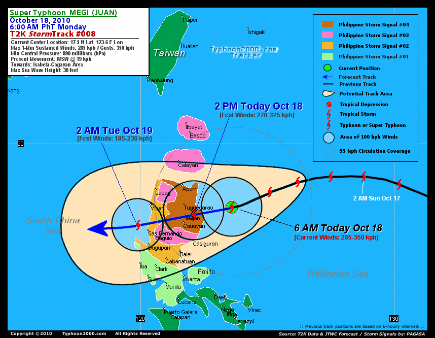
CURRENT STORM INFORMATION ANALYSIS & FORECAST OUTLOOK (up to 48 hours)* EXTENDED FORECAST TRACK (3 to 5 days)* EFFECTS & HAZARDS Important Note: Please keep in mind that the above forecast outlook, extended forecast, effects-hazards, current monsoon intensity, & tropical cyclone watch changes every 6 to 12 hrs! PHILIPPINE STORM WARNING SIGNAL # FOUR (4) PHILIPPINE STORM SIGNAL # THREE (3) PHILIPPINE STORM WARNING SIGNAL # TWO (2) The above areas will experience stormy weather beginning today (with winds not exceeding 100 kph...and more than 100 kph for #03...and in excess of 185 kph for #04). Coastal waters will be rough to very rough and extremely dangerous to all types of seacrafts. PHILIPPINE STORM WARNING SIGNAL # ONE (1) The above areas will have rains and winds of not more than 60 kph beginning today. Coastal waters will be moderate to rough.
Time/Date: 6:00 AM PhT Mon Oct 18 2010
Location of Eye: 17.5º N Lat 123.6º E Lon
Distance 1: 195 km (105 nm) ENE of Ilagan, Isabela
Distance 2: 200 km (108 nm) East of Tuguegarao City
Distance 3: 215 km (115 nm) ENE of Cauayan, Isabela
Distance 4: 215 km (115 nm) NE of Casiguran, Aurora
Distance 5: 220 km (120 nm) SE of Aparri, Cagayan
Distance 6: 325 km (175 nm) ESE of Laoag City
Distance 7: 340 km (183 nm) East of Vigan City
Distance 8: 340 km (183 nm) ENE of Baguio City
Distance 9: 420 km (227 nm) NE of Metro Manila
Distance 10: 435 km (235 nm) North of Metro Naga/CWC
MaxWinds (1-min avg): 285 kph (155 kts) near the center
Peak Wind Gusts: 350 kph (190 kts)
Present Movement: WSW @ 19 kph (10 kts)
Towards: Isabela
24-hr Rain Amounts (near center): 350 mm (Heavy)
Minimum Central Pressure: 890 millibars (hPa)
Saffir-Simpson Typhoon Scale: Category 5
Size (in Diameter): 1,055 km (570 nm) / Very Large
Max Sea Wave Height (near center): 38 ft (11.5 m)
Possible Storm Surge Height: >18 ft [>5.5 m]
T2K TrackMap #008 (for Public): 6 AM PhT Mon Oct 18
MEGI appears to have reached a peak intensity of 295 to 305 km/hr between 8 PM Oct 17 and 2 AM Oct 18 (12:00 and 18:00 GMT), based on 7:15 PM and 8:06 PM Aircraft Dropsonde (Vortex) messages - showing 307 km/hr (163 knots) maximum surface winds and a mean sea level pressure (MSLP) of 893 millibars (hPa). Super Typhoon MEGI's forecast track has changed...it is now expected to make landfall over Isabela between 12 to 1 PM today...and will cross Northern Luzon in a WSW direction...passing very close to Ilagan City, Isabela around 2 PM....and will be over the Banaue Rice Terraces in Ifugao around 5 PM. The typhoon shall be over the southern part of Ilocos Sur or just along the La Union-Ilocos Sur Border between 6 to 7 PM tonight...and will be over the South China Sea around 9 PM [2PM OCT 18: 17.2N 122.1E @ 270kph...2AM OCT 19: 16.8N 119.9E @ 185kph].. Projected Landfall Area (Time): Along Palanan Bay, Isabela...which is about 65 km ENE of Ilagan City between 12 to 1 PM this afternoon. MEGI will be downgraded to a Category 3 typhoon after crossing the mountains of Northern Luzon...and will start to reintensify while over the South China Sea Tuesday evening...and shall exit the Philippine Area of Responsibility (PAR) on Wednesday [2PM OCT 19: 16.7N 118.2E @ 195kph...2AM OCT 20: 16.9N 116.9E @ 205kph].
Maximum Sustained Winds (1-min. avg) are near 285 km/hr (155 knots) with higher gusts. MEGI is a Category 5 Typhoon on the Saffir-Simpson Tropical Cyclone Scale. Typhoon Force Winds (118 km/hr or more) extend outward up to 110 kilometers (60 nautical miles) from the center...and Tropical Storm Force Winds (62-117 km/hr) extend outward up to 280 kilometers (150 nautical miles). MEGI is a very large-sized tropical cyclone with a diameter of 1,055 kilometers (570 nautical miles) across.
THURSDAY EARLY MORNING: Turning WNW slowly across the South China Sea...regains Category 4 strength...threatens Southern China [2AM OCT 21: 17.4N 115.2E @ 215kph].
FRIDAY EARLY MORNING: Remains at Category 4...still moving slowly towards Southern China-Hainan Area [2AM OCT 22: 18.2N 113.8E @ 215kph].
SATURDAY EARLY MORNING Downgraded to Category 3 as MEGI begins to weaken...turns more NW'ly as it approaches the the coastal areas of Eastern Hainan & Western Guangdong (just SW of Hong Kong) [2AM OCT 23: 19.8N 112.4E @ 205kph].
*Please be reminded that the Forecast Outlook changes every 6 hours, and the Extended Forecast Track have an average error of 250 km on Day 3...450 km on Day 4...and 650 km on Day 5, while the wind speed forecast error, averages 35 kph per day. Therefore, a turn to the left or right of its future track and changes in its wind speed must be anticipated from time to time.
MEGI's core (eye and eyewall) approaching the coast of Isabela-Cagayan. Its inner rainbands are just along the coast...while the outer rainbands remain across Northern Luzon...and are now spreading slowly into Central Luzon. Moderate to strong winds of up to 35 km/hr can be expected along the outer rainbands Tropical Storm Conditions w/ Tropical Storm Force Winds are now starting occurring across Cagayan and Isabela...becoming Typhoon Conditions around noon today (click here to view the latest NOAA-CIRA's Wind Analysis). 24-hr total rainfall amounts of 5 up to 150 mm (light to moderate rain) can be expected along its outer and inner bands or across Northern Luzon today...with isolated amounts of up to 350 mm (heavy) near the center of MEGI...or over Cagayan before noon today (Click here to view the latest NOAA's eTRaP graphic on the storm's rainfall amount). Possible coastal Storm Surge flooding of more than 18 feet above normal tide levels...accompanied by large and dangerous battering waves...is possible along the coastal and beach front areas of Northern Luzon particularly along Cagayan and Isabela beginning today. Catastrophic damage is likely on this type of storm surge. Danger from Rip Currents or Rip Tides can be expected along the rest of the beach-front areas of Eastern & Western Luzon including Bicol Region today.![]()
PAGASA Philippine Storm Warnings Signals

In Effect: CAGAYAN, ISABELA, KALINGA, MT. PROVINCE, & IFUGAO.
In Effect: BATANES-CALAYAN-BABUYAN GROUP OF ISLANDS, APAYAO, BENGUET, QUIRINO, NUEVA VIZCAYA, & NORTHERN AURORA.
In Effect: ILOCOS PROVINCES, ABRA, LA UNION, REST OF AURORA, PANGASINAN, TARLAC, NUEVA ECIJA, & POLILLO ISLAND
In Effect: METRO MANILA, CAVITE, BULACAN, PAMPANGA, BATAAN, ZAMBALES, NORTHERN QUEZON, RIZAL, LAGUNA, & BATANGAS.
Residents living in low-lying and mountainous areas under Public Storm Warning Signal Numbers 4, 3, 2, & 1 are alerted against flashfloods, mudslides and landslides...while those living in coastal & beach-front areas are advised to seek higher grounds due to possible storm surge (aka. big waves).
External Links for STY MEGI (JUAN)
View NOAA-CIRA's Latest Wind Analysis
JTWC Latest Tracking Chart: wp1510.gif
Multi-Agency Forecast TrackMap: Near Real-Time
TSR Wind Probabilities: Current to 120 hrs Ahead
NASA-JAXA TMI Page: Latest Rainrate 01
EORC-JAXA TRMM Page: Latest Rainrate 02
Zoomed Satellite Pic: NOAA's Near Real-Time
Wunderground Animation: 6-12 hr. GIF Loop
*SUPER TYPHOON (STY) 15W (MEGI) LOCATED APPROXIMATELY 255 NM
NORTHEAST OF MANILA, PHILIPPINES, HAS TRACKED WEST-SOUTHWESTWARD AT
10 KNOTS OVER THE PAST SIX HOURS. ANIMATED INFRARED SATELLITE
IMAGERY DEPICTS A WELL-DEFINED 25 NM DIAMETER EYE WITH A CONCENTRIC
EYE WALL AND EXCELLENT RADIAL OUTFLOW. THERE IS HIGH CONFIDENCE IN
THE CURRENT POSITION BASED ON COINCIDENT EYE FIXES FROM PGTW AND
RJTD AT 17/18Z. STY MEGI APPEARS TO HAVE REACHED A PEAK INTENSITY OF
160 TO 165 KNOTS BETWEEN 17/12Z AND 17/18Z, BASED ON 171115Z AND
171206Z AIRCRAFT VORTEX MESSAGES INDICATING 163 KNOT MAXIMUM SURFACE
WINDS AND A MEAN SEA LEVEL PRESSURE OF 893 MB. THE CURRENT INTENSITY
IS BASED ON DVORAK ESTIMATES OF 155 KNOTS FROM PGTW AND RJTD AND
REFLECTS A SLIGHT WEAKENING DUE TO INITIAL INTERACTION OF THE
WESTERN EXTENT OF THE SYSTEM WITH THE EASTERN COAST OF LUZON.
POLEWARD AND EQUATORWARD OUTFLOW HAVE SUSTAINED AHEAD OF A
TRANSITORY MID-LATITUDE TROUGH AND INTO A TUTT CELL TO THE EAST OF
THE SYSTEM, RESPECTIVELY. STY MEGI IS FORECAST TO MAKE LANDFALL NEAR
CAGAYAN AND ISABELA PROVINCES IN NORTHERN LUZON AND WEAKEN TO
TYPHOON INTENSITY AS IT CROSSES THE CORDILLERA MOUNTAIN RANGE. STY
15W IS EXPECTED TO RE-EMERGE INTO THE SOUTH CHINA SEA NEAR TAU 24
AND RE-INTENSIFY AS IT TRACKS TOWARD SOUTHERN CHINA. NUMERICAL MODEL
GUIDANCE IS IN GOOD AGREEMENT THROUGH TAU 36, WITH THE EXCEPTION OF
GFS WHICH ERRONEOUSLY RE-CURVES THE SYSTEM TOWARD TAIWAN. AFTER TAU
36, THERE IS SOME SPREAD IN THE MODEL TRACKS BASED ON THE TIMING IN
WHICH THE SUBTROPICAL STEERING RIDGE IS EXPECTED TO WEAKEN. THIS
FORECAST IS CLOSE TO MODEL CONSENSUS THROUGH TAU 36, BUT IS SLIGHTLY
SOUTH OF CONSENSUS IN THE LATER TAUS, FAVORING THE MORE CONSISTENT
UKMO, ECMWF, AND JGSM MODEL TRACKERS...(more)
>> MEGI, meaning: Catfish. Name contributed by: RO Korea.
RECENT TYPHOON2000 TRACKING CHART:
RECENT MULTI-AGENCY TROPICAL CYCLONE FORECAST TRACKING CHART:


> Image source: NOAA SATELLITE CENTER
> Image source: Wunderground.com (http://www.wunderground.com/)
____________________________________________________________________________________________________________________
LATEST 24 HR. TOTAL RAINFALL AMOUNTS / ENSEMBLE TROPICAL RAINFALL POTENTIAL (eTRaP):

> Image source: NOAA Satellite & Information Service (http://www.ssd.noaa.gov/PS/TROP/etrap.html)
>> To know the meteorological terminologies and acronyms used on this update visit the ff:
http://typhoon2000.ph/tcterm.htm
http://www.nhc.noaa.gov/aboutgloss.shtml
http://www.srh.noaa.gov/oun/severewx/glossary.php
http://www.srh.weather.gov/fwd/glossarynation.html
http://www.nhc.noaa.gov/acronyms.shtml
__________________________________________________________________________________________
For the complete details on STY MEGI (JUAN)...go visit our website @:
> http://www.typhoon2000.com
> http://www.maybagyo.com
Copyright © 2010 Typhoon2000.com All Rights Reserved

No comments:
Post a Comment