
for Tuesday, 26 October 2010 [12:45 PM PhT]![]()

<<<Typhoon2000.com Mobile >>>
Get the latest 6-hrly SMS Storm Alerts on KATRING!
For more details: Text T2K TYPHOON to
2800 (Globe/TM) | 216 (Smart/TNT) | 2288 (Sun)
*only P2.50 (Smart/Globe) / P2.00 (Sun) per msg received.
powered by: Synermaxx
Typhoon2000 (T2K) NEWS (Tuesday Oct 26 2010):
Currently issuing 6-hrly SMS, web and e-mail updates (except 12 AM) on TY CHABA (KATRING).
CHABA (KATRING) MAX WIND SPEED PER AGENCY:
+ USA (JTWC/1-min avg): 130 km/hr
+ Japan (JMA/10-min avg): 130 km/hr
+ Philippines (PAGASA/10-min avg): 120 km/hr
+ Korea (KMA/10-min avg): 130 km/hr
+ Taiwan (CWB/10-min avg): 125 km/hr
+ Hong Kong (HKO/10-min avg): 120 km/hr
+ Beijing (NMC/2-min avg): 120 km/hr
:: Click here to see Multi-Agency Forecast Tracks
TYPHOON CHABA [KATRING/16W/1014]
T2K E-MAIL ADVISORY NUMBER 013
12:00 PM PhT (04:00 GMT) Tue 26 October 2010
Sources: T2K Extrap Analysis/JTWC Warning #019/SatFixes
View: Advisory Archives (2004-2010)
Typhoon CHABA (KATRING) continues to gain strength as it heads toward Okinawa-Ryukyu Area.
Residents and visitors along Okinawa and Ryukyu Islands should closely monitor the progress of CHABA.
Do not use this for life or death decision. This advisory is intended for additional information purposes only. Kindly refer to your country's official weather agency for local warnings, advisories & bulletins.
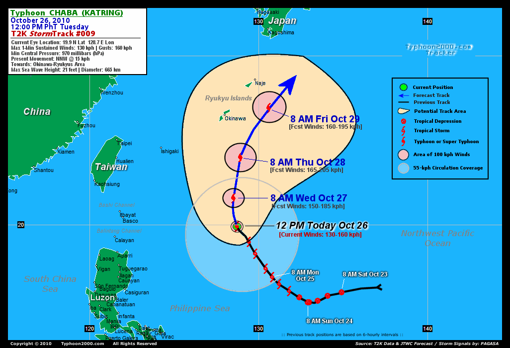
CURRENT STORM INFORMATION
Time/Date: 12:00 PM PhT Tue Oct 26 2010
Location of Cloud-filled Eye: 19.9º N Lat 128.7º E Lon
Distance 1: 700 km (378 nm) ESE of Basco, Batanes
Distance 2: 735 km (397 nm) SSE of Okinawa, Japan
Distance 3: 755 km (408 nm) ENE of Aparri, Cagayan
Distance 4: 810 km (437 nm) NE of Casiguran, Aurora
Distance 5: 1000 km (540 nm) NE of Metro Manila
MaxWinds (1-min avg): 130 kph (70 kts) near the center
Peak Wind Gusts: 160 kph (85 kts)
Present Movement: NNW @ 15 kph (08 kts)
Towards: Okinawa-Ryukyus Area
24-hr Total Rainfall (near center): 480 mm (Heavy)
Minimum Central Pressure: 970 millibars (hPa)
Saffir-Simpson Typhoon Scale: Category 1
Size (in Diameter): 665 km (360 nm) / Avg/Large
Max Sea Wave Height (near center): 21 ft (6.4 m)
Possible Storm Surge Height: 4-5 ft [1.2-1.7 m]
T2K TrackMap #09 (for Public): 12 PM PhT Tue Oct 26
FORECAST OUTLOOK ANALYSIS (up to 48 hours)* EXTENDED FORECAST TRACK (3 to 5 days)*
CHABA is expected to continue tracking NNW within the next 24 hours before it starts to recurve towards the NE - in the direction of Okinawa-Ryukyus Area & Southern Japan. This system will continue to intensify before it leaves the Philippine Area of Responsibility (PAR) and will reach its peak strength (Category 2) by Thursday morning. [8AM OCT 27: 21.6N 128.5E @ 150kph...8PM OCT 27: 22.8N 128.6E @ 160kph...8AM OCT 28: 24.0N 128.79 @ 165kph].
Maximum Sustained Winds (1-min. avg) have increased to near 130 km/hr (70 knots) with higher gusts. CHABA is a Category 1 Typhoon on the Saffir-Simpson Tropical Cyclone Scale. Continued strengthening is expected later today until Thursday. Typhoon Force Winds (118 km/hr or more) extend outward up to 30 kilometers (15 nautical miles) from the center...and Tropical Storm Force Winds (62-117 km/hr) extend outward up to 165 kilometers (90 nautical miles). CHABA is an average to large-sized tropical cyclone with a diameter of 665 kilometers (360 nautical miles).  FRIDAY MORNING: Starts to weaken...passing to the east of Okinawa-Ryukyu Islands...about 260 km East of Naha, Okinawa [8AM OCT 29: 26.9N 130.6E @ 160kph]. SATURDAY MORNING: Begins Extratropical transition...accelerating rapidly NE-ward...approaching the southern coastline of Honshu in Japan...about 270 km SSE of Kochi, Japan [8AM OCT 30: 31.3N 134.8E @ 120kph]. SUNDAY MORNING: Becomes Extratropical upon crossing the SE portion of Honshu, near Tokyo Bay...about 120 km East of Tokyo, Japan [8AM OCT 31: 35.8N 141.0E @ 85kph].
*Please be reminded that the Forecast Outlook changes every 6 hours, and the Extended Forecast Track have an average error of 250 km on Day 3...450 km on Day 4...and 650 km on Day 5, while the wind speed forecast error, averages 35 kph per day. Therefore, a turn to the left or right of its future track and changes in its wind speed must be anticipated from time to time.
EFFECTS & HAZARDS SUMMARY
CHABA maintains a radial circulation with deep raincloud convection near its center and southern periphery. Below are the summary of the typhoon's parts and its hazards affecting specific areas: DEVELOPING EYE - remains at sea (North Philippine Sea)...not affecting land areas. Calm and lull conditions (with <20 kph winds) can be expected inside this area (click here to know more about the EYE). EYEWALL - remains at sea (North Philippine Sea)...not affecting land areas. Typhoon Conditions with typhoon force winds (>118 kph) can be expected within this wall (click here to know more about the Eyewall). INNER SPIRAL RAINBANDS - remains at sea (Philippine Sea)...not affecting land areas. Tropical Storm Conditions w/ Tropical Storm Force Winds (65-117 kph) can be expected within these bands. OUTER SPIRAL RAINBANDS - remains at sea (Philippine Sea)...not affecting land areas. Moderate to strong winds (<65 kph) can be expected within these bands. (click here to know more about Rainbands). 24-HR TOTAL RAINFALL ACCUMULATION - from 5 up to 200 mm (light, moderate to heavy rain) can be expected along the outer & inner rainbands...with isolated amounts of up to 480 mm (heavy) near the center of CHABA [click to open NOAA's eTRaP graphic]. COASTAL STORM SURGE FLOODING - None (click here to know more about Storm Surge).
CURRENT ITCZ/MONSOON TROUGH INTENSITY: MODERATE >> Partly sunny to mostly cloudy skies with isolated to scattered afternoon or evening showers, rains & thunderstorms can be expected along these following affected areas: BICOL REGION, CENTRAL LUZON, METRO MANILA, SOUTHERN LUZON, VISAYAS, & MINDANAO. Light to moderate SW, South, SE winds (not in excess of 30 kph) can be expected today. The prevailing strong La Niña conditions over the Pacific Ocean enhances the ITCZ to be more active across the Philippines.
Important Note: Please keep in mind that the above forecast outlook, extended forecast, effects-hazards, current monsoon intensity, & tropical cyclone watch changes every 6 to 12 hrs!![]()
External Links for TY CHABA (KATRING)
View NOAA-CIRA's Latest Wind Analysis
JTWC Latest Tracking Chart: wp1610.gif
Multi-Agency Forecast TrackMap: Near Real-Time
TSR Wind Probabilities: Current to 120 hrs Ahead
NASA-JAXA TMI Page: Latest Rainrate 01
EORC-JAXA TRMM Page: Latest Rainrate 02
Zoomed Satellite Pic: NOAA's Near Real-Time
Wunderground Animation: 6-12 hr. GIF Loop
*TYPHOON 16W (CHABA), LOCATED APPROXIMATELY 430 NM SOUTH-
SOUTHEAST OF KADENA AIR BASE, JAPAN, HAS TRACKED NORTH-NORTHWESTWARD
AT 5 KNOTS DURING THE PAST SIX HOURS. ANIMATED MULTI-SPECTRAL
SATELLITE IMAGERY SHOWS CONVECTION INTENSIFYING AND CONSOLIDATING
OVER THE LOW LEVEL CIRCULATION CENTER (LLCC). MARKEDLY IMPROVED
POLEWARD OUTFLOW DURING THE PAST SIX HOURS IS RESPONSIBLE FOR MUCH
OF THE INTENSIFICATION. A 252132Z 37GHZ MICROWAVE PASS SHOWS A
DEVELOPING MICROWAVE EYE AND INCREASINGLY WELL ORGANIZED CONVECTIVE
BANDING. INFRARED ANIMATION SHOWS A SHARP INCREASE IN COLD TOPS OVER
THE LLCC DURING THE PAST SIX HOURS. THE INTENSITY ESTIMATE IS BASED
ON A COMBINATION OF DVORAK ESTIMATES OF 65 KNOTS FROM PGTW AND 77
KNOTS FROM RJTD. IN ADDITION TO THE IMPROVING POLEWARD OUTFLOW, WELL
DEVELOPED EQUATORWARD OUTFLOW PERSISTS...(more)
>> CHABA, meaning: Tropical flower (the shoeflower, genus hibiscus). Name contributed by: Thailand.
RECENT TYPHOON2000.COM TRACKING CHART:
RECENT MULTI-AGENCY TROPICAL CYCLONE FORECAST TRACKING CHART:


> Image source: NOAA SATELLITE CENTER
> Image source: Wunderground.com (http://www.wunderground.com/)
____________________________________________________________________________________________________________________
LATEST 24 HR. TOTAL RAINFALL AMOUNTS / ENSEMBLE TROPICAL RAINFALL POTENTIAL (eTRaP):

> Image source: NOAA Satellite & Information Service (http://www.ssd.noaa.gov/PS/TROP/etrap.html)
>> To know the meteorological terminologies and acronyms used on this update visit the ff:
http://typhoon2000.ph/tcterm.htm
http://www.nhc.noaa.gov/aboutgloss.shtml
http://www.srh.noaa.gov/oun/severewx/glossary.php
http://www.srh.weather.gov/fwd/glossarynation.html
http://www.nhc.noaa.gov/acronyms.shtml
__________________________________________________________________________________________
For the complete details on TY CHABA (KATRING)...go visit our website @:
> http://www.typhoon2000.com
> http://www.maybagyo.com
Copyright © 2010 Typhoon2000.com All Rights Reserved

No comments:
Post a Comment