
for Wednesday, 27 October 2010 [5:54 PM PhT]![]()

<<<Typhoon2000.com Mobile >>>
Get the latest 6-hrly SMS Storm Alerts on KATRING!
For more details: Text T2K TYPHOON to
2800 (Globe/TM) | 216 (Smart/TNT) | 2288 (Sun)
*only P2.50 (Smart/Globe) / P2.00 (Sun) per msg received.
powered by: Synermaxx
Typhoon2000 (T2K) NEWS (Tuesday Oct 26 2010):
Currently issuing 6-hrly SMS, web and e-mail updates (except 12 AM) on TY CHABA (KATRING).
CHABA (KATRING) MAX WIND SPEED PER AGENCY:
+ USA (JTWC/1-min avg): 185 km/hr
+ Japan (JMA/10-min avg): 140 km/hr
+ Philippines (PAGASA/10-min avg): 120 km/hr
+ Korea (KMA/10-min avg): 150 km/hr
+ Taiwan (CWB/10-min avg): 145 km/hr
+ Hong Kong (HKO/10-min avg): 140 km/hr
+ Beijing (NMC/2-min avg): 160 km/hr
:: Click here to see Multi-Agency Forecast Tracks
TYPHOON CHABA [KATRING/16W/1014]
T2K E-MAIL ADVISORY NUMBER 017
6:00 PM PhT (10:00 GMT) Wed 27 October 2010
Sources: T2K Extrap Analysis/JTWC Warning #024/SatFixes
View: Advisory Archives (2004-2010)
CHABA (KATRING) has been upgraded to a Category 3 Typhoon as it accelerates northward...threat to Okinawa and Ryukyu Islands increases.
Residents and visitors along Okinawa and Ryukyu Islands should closely monitor the progress of CHABA.
Do not use this for life or death decision. This advisory is intended for additional information purposes only. Kindly refer to your country's official weather agency for local warnings, advisories & bulletins.
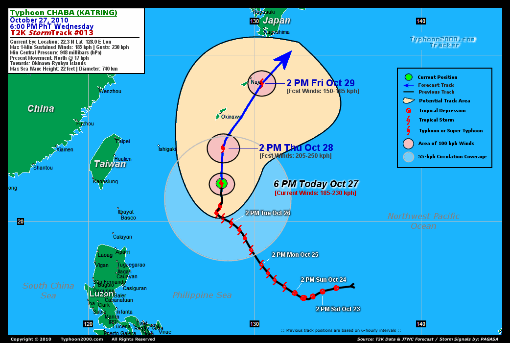
CURRENT STORM INFORMATION
Time/Date: 6:00 PM PhT Wed Oct 27 2010
Location of Eye: 22.3º N Lat 128.0º E Lon
Distance 1: 465 km (250 nm) South of Okinawa, Japan
Distance 2: 650 km (350 nm) ENE of Basco, Batanes
Distance 3: 715 km (385 nm) SE of Aparri, Cagayan
Distance 4: 725 km (392 nm) SSW of Naje Is., Japan
MaxWinds (1-min avg): 185 kph (100 kts) near the center
Peak Wind Gusts: 230 kph (125 kts)
Present Movement: North @ 17 kph (09 kts)
Towards: Okinawa-Ryukyus Area
24-hr Total Rainfall (near center): 350 mm (Heavy)
Minimum Central Pressure: 948 millibars (hPa)
Saffir-Simpson Typhoon Scale: Category 3
Size (in Diameter): 740 km (400 nm) / Large
Max Sea Wave Height (near center): 22 ft (6.7 m)
Possible Storm Surge Height: 9-12 ft [2.7-3.9 m]
T2K TrackMap #13 (for Public): 6 PM PhT Wed Oct 27
FORECAST OUTLOOK ANALYSIS (up to 48 hours)* EXTENDED FORECAST TRACK (3 to 5 days)*
CHABA is expected to continue moving Northward within the next 12 to 24 hours before recurving towards the NE on Friday - in the direction of Okinawa-Ryukyus Area & Southern Japan. By 36 to 48 hours, CHABA will begin Extratropical transition, passing close to Okinawa Island by Friday early morning between 2-4 AM Japan Time (17-19 GMT) - with a close distance of 115 km to the east of Kadena Air Base [2PM OCT 28: 24.4N 128.1E @ 205kph...2AM OCT 29: 26.1N 128.9E @ 185kph...2PM OCT 29: 28.3N 130.4E @ 150kph].
Maximum Sustained Winds (1-min. avg) have increased to near 185 km/hr (100 knots) with higher gusts. CHABA is now a Category 3 Typhoon on the Saffir-Simpson Tropical Cyclone Scale. Continued strengthening is still likely today until tomorrow (Thursday). Typhoon Force Winds (118 km/hr or more) extend outward up to 65 kilometers (35 nautical miles) from the center...and Tropical Storm Force Winds (62-117 km/hr) extend outward up to 285 kilometers (155 nautical miles). CHABA is a large-sized tropical cyclone with a diameter of 740 kilometers (400 nautical miles).  SATURDAY AFTERNOON: Becomes extratropical as it makes landfall over Southern Honhsu, Japan - just south of Kyoto City...about 205 km SW of Nagoya City [2PM OCT 30: 33.7N 135.6E @ 110kph]. SUNDAY AFTERNOON: Exits the NE coast of Honshu after crossing South-Central Honshu...about 285 km ENE of Sendai, Japan [2PM OCT 31: 39.1N 144.0E @ 85kph]. MONDAY AFTERNOON: Passing to the south of Kamchatka Peninsula or over the cooler seas of the Northwest Pacific [2PM NOV 01: 43.3N 155.3E @ 75kph].
*Please be reminded that the Forecast Outlook changes every 6 hours, and the Extended Forecast Track have an average error of 250 km on Day 3...450 km on Day 4...and 650 km on Day 5, while the wind speed forecast error, averages 35 kph per day. Therefore, a turn to the left or right of its future track and changes in its wind speed must be anticipated from time to time.
EFFECTS & HAZARDS SUMMARY
CHABA's deep circulation with pulsating eye appearance remains strong, despite the entrance of cooler air along the western outer bands. Below are the summary of the typhoon's parts and its hazards affecting specific areas: CLOUD-FILLED EYE - remains at sea (North Philippine Sea)...not affecting land areas. Possible calm and lull conditions (with <20 kph winds) can be expected inside the eye (click here to know more about the EYE). EYEWALL - remains at sea (North Philippine Sea)...not affecting land areas. Typhoon Conditions with typhoon force winds (>118 kph) can be expected within this wall (click here to know more about the Eyewall). INNER SPIRAL RAINBANDS - remains at sea (Philippine Sea)...will reach Okinawa tomorrow noontime...and at Naje Island (Ryukyus) on Friday early morning. Tropical Storm Conditions w/ Tropical Storm Force Winds (65-117 kph) can be expected within these bands. OUTER SPIRAL RAINBANDS - spreading across Okinawa and Ryukyu Islands, Where moderate to strong winds (<65 kph) can be expected along these bands today. (click here to know more about Rainbands). 24-HR TOTAL RAINFALL ACCUMULATION - from 5 up to 200 mm (light, moderate to heavy rain) can be expected along the outer & inner rainbands...with isolated amounts of up to 350 mm (heavy) near the center of CHABA [click to open NOAA's eTRaP graphic]. COASTAL STORM SURGE FLOODING - possible 4 to 12 feet above normal tide levels...accompanied by large and dangerous battering waves can be expected along the coastal and beach front areas of Batanes, Eastern Taiwan, Okinawa & Ryukyu Islands today. Minimal to moderate damage is likely on this type of storm surge. Danger from Rip Currents or Rip Tides can be expected along the beach-front areas of Northern & Eastern Luzon today. (click here to know more about Storm Surge).
CURRENT NORTHEAST MONSOON INTENSITY: MODERATE >> Partly sunny to mostly cloudy skies with passing showers or rains can be expected along these following affected areas: NORTHERN & EASTERN LUZON, BICOL REGION. Lower temperatures (less than 30 degrees celsius) with cooler light to moderate North and NE winds (not in excess of 30 kph) can be expected today.
CURRENT ITCZ/MONSOON TROUGH INTENSITY: STRONG >> Mostly cloudy skies with scattered to widespread showers, rains & thunderstorms can be expected along these following affected areas: VISAYAS, MASBATE, PALAWAN & MINDANAO. Light to moderate NW, SE to variable winds (not in excess of 30 kph) can be expected today.
Important Note: Please keep in mind that the above forecast outlook, extended forecast, effects-hazards, current monsoon intensity, & tropical cyclone watch changes every 6 to 12 hrs!![]()
External Links for TY CHABA (KATRING)
View NOAA-CIRA's Latest Wind Analysis
JTWC Latest Tracking Chart: wp1610.gif
Multi-Agency Forecast TrackMap: Near Real-Time
TSR Wind Probabilities: Current to 120 hrs Ahead
NASA-JAXA TMI Page: Latest Rainrate 01
EORC-JAXA TRMM Page: Latest Rainrate 02
Zoomed Satellite Pic: NOAA's Near Real-Time
Wunderground Animation: 6-12 hr. GIF Loop
*TYPHOON (TY) 16W (CHABA), LOCATED APPROXIMATELY 275 NM SOUTH OF
KADENA AIR BASE, JAPAN, HAS TRACKED NORTHWARD AT 08 KNOTS OVER
THE PAST SIX HOURS. THERE IS HIGH CONFIDENCE IN THE CURRENT LOCATION
BASED ON A VISIBLE 10 NM RAGGED EYE. RECENT 500 MB CHARTS INDICATE
THE WESTERN FINGER OF THE DEEP LAYER STEERING RIDGE THAT HAD BEEN
INHIBITING A NORTHWARD TURN HAS SUFFICIENTLY ERODED. THIS WEAKENING
WILL ALLOW FOR CONTINUED POLEWARD MOTION THROUGHOUT THE FORECAST.
DESPITE IMPRESSIVE POLEWARD OUTFLOW INTO A LONGWAVE TROUGH LOCATED
OVER THE NORTH CENTRAL PACIFIC THE SYSTEM HAS INTENSIFIED LITTLE
SINCE THE PREVIOUS FORECAST. CURRENT DVORAK ESTIMATES FROM PGTW AND
RJTD RANGE FROM 90 TO 102 KNOTS. MODERATE VERTICAL WIND SHEAR ON THE
NORTH AND WEST SIDES OF THE TY HAVE LIKELY MODERATED
INTENSIFICATION. IN ADDITION, THE SYSTEM CONTINUES TO PULL MODIFIED
CONTINENTAL POLAR AIR ASSOCIATED WITH A COLD SURGE INTO ITS CENTER
FROM THE WEST. STRATOCUMULUS CLOUDS, INDICATIVE OF A DRIER AND MORE
STABLE AIRMASS, CAN BE SEEN WRAPPING BENEATH THE CENTRAL CONVECTION
IN ANIMATED MULTISPECTRAL SATELLITE IMAGERY. VERTICAL WIND SHEAR
ELEVATES CONSIDERABLY TO THE NORTH OF OKINAWA AND SHOULD WEAKEN THE
TY MORE THAN PREVIOUSLY FORECAST. EXTRATROPICAL TRANSITION WILL
STILL BEGIN AROUND TAU 48 (NORTH OF OKINAWA) AND COMPLETE SOUTH OF
KYOTO. BEYOND TAU 72 THE EXTRATROPICAL CYCLONE WILL ACCELERATE INTO
THE MID-LATITUDES AS IT SKIRTS SOUTHERN HONSHU. THE FORECAST REMAINS
FASTER THAN THE MODEL CONSENSUS AFTER TAU 36, BUT NOT QUITE AS FAST
AS THE PREVIOUS FORECAST...(more)
>> CHABA, meaning: Tropical flower (the shoeflower, genus hibiscus). Name contributed by: Thailand.
RECENT TYPHOON2000.COM TRACKING CHART:
RECENT MULTI-AGENCY TROPICAL CYCLONE FORECAST TRACKING CHART:


> Image source: NOAA SATELLITE CENTER
> Image source: Wunderground.com (http://www.wunderground.com/)
____________________________________________________________________________________________________________________
LATEST 24 HR. TOTAL RAINFALL AMOUNTS / ENSEMBLE TROPICAL RAINFALL POTENTIAL (eTRaP):

> Image source: NOAA Satellite & Information Service (http://www.ssd.noaa.gov/PS/TROP/etrap.html)
>> To know the meteorological terminologies and acronyms used on this update visit the ff:
http://typhoon2000.ph/tcterm.htm
http://www.nhc.noaa.gov/aboutgloss.shtml
http://www.srh.noaa.gov/oun/severewx/glossary.php
http://www.srh.weather.gov/fwd/glossarynation.html
http://www.nhc.noaa.gov/acronyms.shtml
__________________________________________________________________________________________
For the complete details on TY CHABA (KATRING)...go visit our website @:
> http://www.typhoon2000.com
> http://www.maybagyo.com
Copyright © 2010 Typhoon2000.com All Rights Reserved

No comments:
Post a Comment