
for Wednesday, 20 October 2010 [12:35 PM PhT]![]()

<<<Typhoon2000.com Mobile >>>
Get the latest 6-hrly SMS Storm Alerts on JUAN!
For more details: Text T2K TYPHOON to
2800 (Globe/TM) | 216 (Smart/TNT) | 2288 (Sun)
*only P2.50 (Smart/Globe) / P2.00 (Sun) per msg received.
powered by: Synermaxx
Typhoon2000 (T2K) NEWS (Tuesday Oct 19 2010):
Ending the 3-hrly Web & SMS updates (except 12 AM) on MEGI (JUAN)...now back to its usual 6-hrly updates.
MEGI (JUAN) MAX WIND SPEED PER AGENCY:
+ USA (JTWC/1-min avg): 215 km/hr
+ Japan (JMA/10-min avg): 165 km/hr
+ Philippines (PAGASA/10-min avg): 175 km/hr
+ Korea (KMA/10-min avg): 160 km/hr
+ Taiwan (CWB/10-min avg): 170 km/hr
+ Beijing (NMC/2-min avg): 185 km/hr
+ Hong Kong (HKO/10-min avg): 175 km/hr
TYPHOON MEGI [JUAN/15W/1013]
T2K PUBLIC ADVISORY NUMBER 023
12:00 PM PhT (04:00 GMT) Wed 20 October 2010
Sources: T2K Extrap Analysis/JTWC Wrng #029/SatFixes
View: Advisory Archives (2004-2010)
Typhoon MEGI (JUAN) has maintained its strength as it continues to wobble slowly northward...now threatens Southern and Southeastern China.
Residents and visitors along Southern & Southeastern China and Taiwan should closely monitor the progress of MEGI (JUAN).
Do not use this for life or death decision. This advisory is intended for additional information purposes only. Kindly refer to your country's official weather agency for local warnings, advisories & bulletins.
CURRENT STORM INFORMATION ANALYSIS & FORECAST OUTLOOK (up to 48 hours)* EXTENDED FORECAST TRACK (3 to 5 days)* EFFECTS & HAZARDS SUMMARY TROPICAL CYCLONE WATCH Important Note: Please keep in mind that the above forecast outlook, extended forecast, effects-hazards, current monsoon intensity, & tropical cyclone watch changes every 6 to 12 hrs! PHILIPPINE STORM WARNING SIGNAL # ONE (1) The above areas will have rains and winds of not more than 60 kph today. Coastal waters will be moderate to rough.
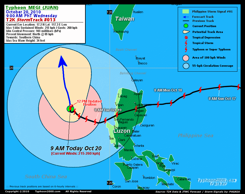
Time/Date: 12:00 PM PhT Tue Oct 20 2010
Location of Eye: 17.4º N Lat 117.4º E Lon
Distance 1: 285 km (155 nm) NW of Bolinao, Pangasinan
Distance 2: 320 km (173 nm) West of Vigan City
Distance 3: 350 km (190 nm) WSW of Laoag City
Distance 4: 505 km (273 nm) NW of Metro Manila
Distance 5: 640 km (345 nm) SE of Hong Kong
Distance 6: 670 km (360 nm) South of Shantou, China
MaxWinds (1-min avg): 215 kph (115 kts) near the center
Peak Wind Gusts: 260 kph (140 kts)
Present Movement: North @ 05 kph (03 kts)
Towards: Southeastern China (Eastern Guangdong)
24-hr Total Rainfall (near center): 500 mm (Very Heavy)
Minimum Central Pressure: 945 millibars (hPa)
Saffir-Simpson Typhoon Scale: Category 4
Size (in Diameter): 1,000 km (540 nm) / Very Large
Max Sea Wave Height (near center): 36 ft (10.9 m)
Possible Storm Surge Height: 13-18 ft [4-5.5 m]
T2K TrackMap #013 (for Public): 12 PM PhT Wed Oct 20
MEGI has maintained its organization, with a banding eye at the center...and continues to have a very large circulation (>890 km) covering the whole extent of the South China Sea. The typhoon is expected to continue moving northward slowly towards Southeastern-Southern China Area within the next two days. MEGI is forecast to intensify to near-Super Typhoon strength sometime tomorrow and will start to decay as it approaches the shores of Eastern Guangdong, just to the east of Hong Kong on Friday [8AM OCT 21: 18.8N 117.1E @ 230kph...8AM OCT 22: 21.3N 117.1E @ 195kph].
Maximum Sustained Winds (1-min. avg) remain near 215 km/hr (115 knots) with higher gusts. MEGI is a Category 4 Typhoon on the Saffir-Simpson Tropical Cyclone Scale. Additional strengthening can still be expected tomorrow. Typhoon Force Winds (118 km/hr or more) extend outward up to 120 kilometers (65 nautical miles) from the center...and Tropical Storm Force Winds (62-117 km/hr) extend outward up to 350 kilometers (190 nautical miles). MEGI remains a very large-sized tropical cyclone, measuring about 1,000 kilometers (540 nautical miles) across.  SATURDAY MORNING: Downgraded to Category 2 as it makes landfall over Eastern Guangdong Province in China [8AM OCT 23: 23.2N 116.3E @ 160kph]. SUNDAY MORNING: Dissipating inland as it moves NW across Guangdong Province...just a strong tropical storm [8AM OCT 24: 24.2N 115.4E @ 110kph]. MONDAY MORNING Just barely a tropical storm as it continues to dissipate along the Jiangxi-Gunagdong Border...about 280 km north of Hong Kong. [8AM OCT 25: 24.9N 114.4E @ 65kph].
*Please be reminded that the Forecast Outlook changes every 6 hours, and the Extended Forecast Track have an average error of 250 km on Day 3...450 km on Day 4...and 650 km on Day 5, while the wind speed forecast error, averages 35 kph per day. Therefore, a turn to the left or right of its future track and changes in its wind speed must be anticipated from time to time.
MEGI's very large convective circulation continues to cover a vast area of South China Sea and some parts of Luzon, Palawan and Mindoro in the Philippines. IRREGULAR EYE [28-km diameter] - remains over water (South China Sea). EYEWALL - over water (South China Sea). INNER RAINBANDS - its outer edges continues to affect the western shorelines of Pangasinan, La Union, Ilocos Sur, & Ilocos Norte - where Tropical Storm Conditions w/ Tropical Storm Force Winds (65-117 kph) will prevail today. OUTER RAINBANDS - spreading across the whole of Luzon (except Cagayan, Isabela & Northern Aurora), Mindoro, Lubang Is, Calamian Group, & Northern Palawan. Moderate to strong winds with passing on-and-off showers, squalls or thunderstorms can be expected along these areas today. 24-HR TOTAL RAINFALL ACCUMULATION - from 5 up to 200 mm (light to heavy rain) can be expected along the outer and inner rainbands...with isolated amounts of up to 500 mm (very heavy) near the center of MEGI [view current NOAA's eTRaP graphic]. COASTAL STORM SURGE FLOODING - possible 13 to 18 feet above normal tide levels...accompanied by large and dangerous battering waves can be expected along the coastal and beach front areas of Western Luzon today...and in Guangdong Province, China beginning tomorrow until Saturday. Extreme damage is likely on this type of storm surge. Danger from large swells and Rip Currents or Rip Tides can be expected along the rest of the beach-front areas of Southern China, Western Visayas, Southern & Eastern Luzon in the Philippines today.
The strong Tropical Disturbance 95W (LPA/1006 MB) continues to move closer to Saipan. It was located near lat 16.0N lon 147.1E...or about 175 km ENE of Saipan, CNMI...with 1-min maximum sustained winds of 35 kph near the center...moving West @ 22 kph towards Northern Marianas. The 24 to 48-Hr. Tropical Cyclone Formation Potential on this system is at 60%. Click here to view current satellite image and flash animation. ![]()
PAGASA Philippine Storm Warnings Signals

In Effect: ILOCOS NORTE, ILOCOS SUR, LA UNION, BENGUET, PANGASINAN, & ZAMBALES.
Residents living in low-lying and mountainous areas under Public Storm Warning Signal Numbers 2, & 1 are alerted against flashfloods, mudslides and landslides...while those living in coastal & beach-front areas are advised to seek higher grounds due to possible storm surge (aka. big waves).
External Links for TY MEGI (JUAN)
View NOAA-CIRA's Latest Wind Analysis
JTWC Latest Tracking Chart: wp1510.gif
Multi-Agency Forecast TrackMap: Near Real-Time
TSR Wind Probabilities: Current to 120 hrs Ahead
NASA-JAXA TMI Page: Latest Rainrate 01
EORC-JAXA TRMM Page: Latest Rainrate 02
Zoomed Satellite Pic: NOAA's Near Real-Time
Wunderground Animation: 6-12 hr. GIF Loop
*TYPHOON (TY) 15W (MEGI), LOCATED APPROXIMATELY 350 NM SOUTH-
SOUTHEAST OF HONG KONG, CHINA HAS TRACKED NORTHWESTWARD AT 03 KNOTS
OVER THE PAST SIX HOURS. ANIMATED MULTISPECTRAL SATELLITE IMAGERY
SHOWS A BANDING EYE WITH A DECREASE IN DEEP CONVECTIVE BANDING ON
THE NORTHERN PERIPHERY OF THE SYSTEM. HOWEVER, THE OVERALL SYSTEM
SIZE HAS EXPANDED WITH INCREASED CONVECTION IN THE SOUTHERN
PERIPHERY. THE CURRENT POSITION IS CENTERED ON THE BANDING EYE
FEATURE AS DEPICTED IN THE MULTISPECTRAL IMAGERY AND THE CURRENT
INTENSITY IS BASED ON A PGTW DVORAK ESTIMATE OF 115 KNOTS. WATER
VAPOR ANIMATION DEPICTS EXCELLENT RADIAL OUTFLOW. TY 15W IS IN A
WEAK STEERING ENVIRONMENT, SLOWLY TRACKING ALONG THE SOUTHWESTERN
PERIPHERY OF A MID-LEVEL SUBTROPICAL RIDGE WEAKENED BY A DEEPENING
MID-LATITUDE SHORTWAVE TROUGH MOVING OVER SOUTHEAST CHINA.
..(more)
>> MEGI, meaning: Catfish. Name contributed by: RO Korea.
RECENT TYPHOON2000 TRACKING CHART:
RECENT MULTI-AGENCY TROPICAL CYCLONE FORECAST TRACKING CHART:


> Image source: NOAA SATELLITE & INFORMATION SERVICE
> Image source: Wunderground.com (http://www.wunderground.com/)
____________________________________________________________________________________________________________________
LATEST 24 HR. TOTAL RAINFALL AMOUNTS / ENSEMBLE TROPICAL RAINFALL POTENTIAL (eTRaP):

> Image source: NOAA Satellite & Information Service (http://www.ssd.noaa.gov/PS/TROP/etrap.html)
>> To know the meteorological terminologies and acronyms used on this update visit the ff:
http://typhoon2000.ph/tcterm.htm
http://www.nhc.noaa.gov/aboutgloss.shtml
http://www.srh.noaa.gov/oun/severewx/glossary.php
http://www.srh.weather.gov/fwd/glossarynation.html
http://www.nhc.noaa.gov/acronyms.shtml
__________________________________________________________________________________________
For the complete details on TY MEGI (JUAN)...go visit our website @:
> http://www.typhoon2000.com
> http://www.maybagyo.com
Copyright © 2010 Typhoon2000.com All Rights Reserved

No comments:
Post a Comment