
for Saturday, 07 May 2011 [1:27 PM PhT]![]()

<<<Typhoon2000.com Mobile >>>
Get the latest 3-Hourly SMS Storm Alerts on BEBENG!
For more details: Text T2K TYPHOON to
2800 (Globe/TM) | 216 (Smart/TNT) | 2288 (Sun)
*only P2.50 (Smart/Globe) / P2.00 (Sun) per msg received.
powered by: Synermaxx
Typhoon2000 (T2K) NEWS (Saturday May 07 2011):
Now issuing 3-hrly web and e-mail updates (except 12 AM) on TS 03W (BEBENG) as it nears Samar-Bicol Area.
03W (BEBENG) MAX WIND SPEED PER AGENCY:
+ USA (JTWC/1-min avg): 65 km/hr
+ Japan (JMA/10-min avg): 55 km/hr
+ Philippines (PAGASA/10-min avg): 55 km/hr
TROPICAL STORM 03W [BEBENG]
T2K PUBLIC ADVISORY NUMBER 003
12:00 PM PhT (04:00 GMT) Sat 07 May 2011
Sources: T2K Extrap Analysis/JTWC Warning #004/SatFixes
View: Advisory Archives (2004-2011)
03W (BEBENG) is now a Tropical Storm as it tracks Westward during the past 3 hours...Western rainbands continues to spread across the Bicol Region and Eastern Visayas.
Residents and visitors along Eastern Luzon, Bicol Region and Eastern Visayas should closely monitor the progress of 03W (BEBENG).
Do not use this for life or death decision. This advisory is intended for additional information purposes only. Kindly refer to your country's official weather agency for local warnings, advisories & bulletins.
CURRENT STORM INFORMATION
Time/Date: 12:00 PM PhT Sat May 07 2011
Location of Center: 12.6º N Lat 126.3º E Lon
Distance 1: 185 km (100 nm) East of Catarman, N.Samar
Distance 2: 255 km (138 nm) SE of Virac, Catanduanes
Distance 3: 255 km (138 nm) ESE of Sorsogon City
Distance 4: 290 km (157 nm) ESE of Legazpi City
Distance 5: 325 km (175 nm) ESE of Iriga City
Distance 6: 355 km (192 nm) ESE of Metro Naga/CWC
Distance 7: 605 km (325 nm) SE of Metro Manila
MaxWinds (1-min avg): 65 kph (35 kts) near the center
Peak Wind Gusts: 85 kph (45 kts)
Present Movement: West @ 15 kph (08 kts)
Towards: Eastern Coast of Bicol
CPA over Bicol Area: 5-8AM Sunday
24hr Total Rainfall (near center): 300 mm (Heavy-Very Heavy)
Minimum Central Pressure: 996 millibars (hPa)
Saffir-Simpson Typhoon Scale: TS
Size (in Diameter): 500 km (270 nm) / Average
Max Sea Wave Height (near center): 14 ft (4.5 m)
Possible Storm Surge Height: 0 ft [0 m]
T2K TrackMap (for Public): 12:00 PM PhT Sat May 07
FORECAST OUTLOOK ANALYSIS (up to 48 hours)* EXTENDED FORECAST TRACK (3 to 5 days)*
03W (BEBENG) is expected to maintain its NW-ward track in the direction of the Eastern Coast of the Bicol Region for the next 2 days and will continue to intensify. This system shall pass close to the shores of Northern Catanduanes tomorrow morning (Sun May 08) between 5-8AM...or about 95 km to the NE of Virac, Catanduanes or about 175 km ENE of Metro Naga. Its Closest Point of Approach (CPA) to Metro Naga shall be more or less 160 km to the NE of the city around 8AM tomorrow [8PM MAY 07: 13.7N 125.6E @ 85 kph...8AM MAY 08: 14.6N 124.3E @ 95kph]. By tomorrow evening (May 8), it shall be reaching its peak strength of 100 kph...about 115 km SE of Casiguran, Aurora and shall make landfall just to the NE of Casiguran, Aurora between 4-5AM on Monday May 09...about 45 km ESE of Cauayan, Isabela [8PM MAY 08: 15.6N 123.0E @ 100kph...8AM MAY 09: 16.6N 122.0E @ 95kph].
Maximum Sustained Winds (1-min. avg) are near 65 km/hr (35 knots) with higher gusts. 03W (BEBENG) is now a Tropical Storm on the Saffir-Simpson Tropical Cyclone Scale.  TUESDAY MORNING: Weakening gradually after traversing Northern Luzon...shall be over the Balintang Channel...about 105 km West of Calayan Island [8AM MAY 10: 19.4N 120.5E @ 65kph]. WEDNESDAY MORNING: Downgraded to a Tropical Depression (TD) as it makes landfall over Southern Taiwan...about 55 km ESE of Kaohsiung City, Taiwan [8AM MAY 11: 22.4N 120.8E @ 55kph]. THURSDAY MORNING: Moving out of Taiwan as it is being absorbed by a passing frontal system...about 140 km ENE of Taipei, Taiwan [8AM MAY 12: 25.5N 122.9E @ 55kph].
*Please be reminded that the Forecast Outlook changes every 6 hours, and the Extended Forecast Track have an average error of 250 km on Day 3...450 km on Day 4...and 650 km on Day 5, while the wind speed forecast error, averages 35 kph per day. Therefore, a turn to the left or right of its future track and changes in its wind speed must be anticipated from time to time.
EFFECTS & HAZARDS SUMMARY
03W's circulation continues to strengthen while over water (South Philippine Sea) w/ its improved rainbands affecting the Bicol Region, Visayas & Northeastern Mindanao. Below are the summary of the storm's parts and its hazards affecting specific areas: INNER RAINBANDS - affecting Samar Provinces including the east coast of Sorsogon & Catanduanes...expected to reach the rest of Bicol Region this afternoon or tonight. Tropical Storm Conditions w/ Tropical Storm Force Winds (65-85 kph) can be expected along these bands. OUTER RAINBANDS - spreading across the Rest of the Bicol Region, Masbate, & Rest of Visayas, where light to moderate winds (<40 kph) can be expected along these bands. (click here to know more about Rainbands). 24HR TOTAL RAINFALL ACCUMULATION - from 5 up to 150 mm (light to heavy rain) can be expected along the outer & inner rainbands...with isolated amounts of up to 300 mm (heavy to very heavy) near the center of 03W. [click to open NOAA's eTRaP graphic].
TROPICAL CYCLONE WATCH CURRENT ITCZ/MONSOON TROUGH INTENSITY: MODERATE >> Partly sunny to mostly cloudy with scatt$ered showers, rains & thunderstorms can be expected along these following affected areas: PALAWAN & MINDANAO. Light to moderate W, SW to variable winds (not in excess of 35 kph) can be expected today and tomorrow.
Tropical Disturbance 94W (LPA/1010 MB) remains disorganized over the Caroline Islands just north of the Equator, south of Guam. The ill-defined center was located near lat 1.3N lon 144.5E...about 1295 km SE of Palau Islands or 2095 km SE of Mindanao, PH...with 1-min maximum sustained winds of 30 kph near the center. The 48-Hr. Tropical Cyclone Formation Potential on this system remains @ 30%. Click here to view current satellite image and flash animation.
Important Note: Please keep in mind that the above forecast outlook, extended forecast, effects-hazards, current monsoon intensity, & tropical cyclone watch changes every 6 to 12 hrs!
JTWC (US NAVY & AIR FORCE) REMARKS:
REMARKS (for Meteorologists): 8 AM (00 GMT) SAT 07 MAY POSITION: 12.8N 126.8E.
*ANIMATED MULTISPECTRAL SATELLITE IMAGERY (MSI) DEPICTS A PARTIALLY
EXPOSED LOW LEVEL CIRCULATION CENTER (LLCC) WITH A MAJORITY OF THE
DEEPEST CONVECTION ALONG THE WESTERN PERIPHERY OF THE SYSTEM. RECENT
MICROWAVE IMAGES (062226Z SSMIS AND 062330Z SSMIS) INDICATE TIGHTLY
CURVED BANDING WRAPPING INTO A WELL-DEFINED LLCC. THE CURRENT INTEN-
SITY IS BASED ON DVORAK INTENSITY ESTIMATES OF 35 KNOTS FROM PGTW AND
KNES, AND ON THE INCREASED CONVECTIVE STRUCTURE IN MICROWAVE AND VISIBLE
SATELLITE IMAGERY. THERE IS HIGH CONFIDENCE IN THE CURRENT POSITION
BASED ON THE PARTIALLY EXPOSED LLCC EVIDENT IN MSI. OVERALL, THE
UPPER LEVEL ENVIRONMENT REMAINS FAVORABLE DUE TO LOW VERTICAL WIND
SHEAR (<10 KNOTS) AND STRONGLY DIFFLUENT FLOW ALOFT. HOWEVER,
OUTFLOW FROM AN ANTICYCLONE CENTERED SLIGHTLY TO THE NORTHWEST OF TS
03W IS CAUSING MOST OF THE CONVECTION TO BE DISPLACED WEST-
SOUTHWESTWARD...(more)
_______________________________________________________________________________________________________________________________________
RECENT TYPHOON2000.COM TRACKING CHART: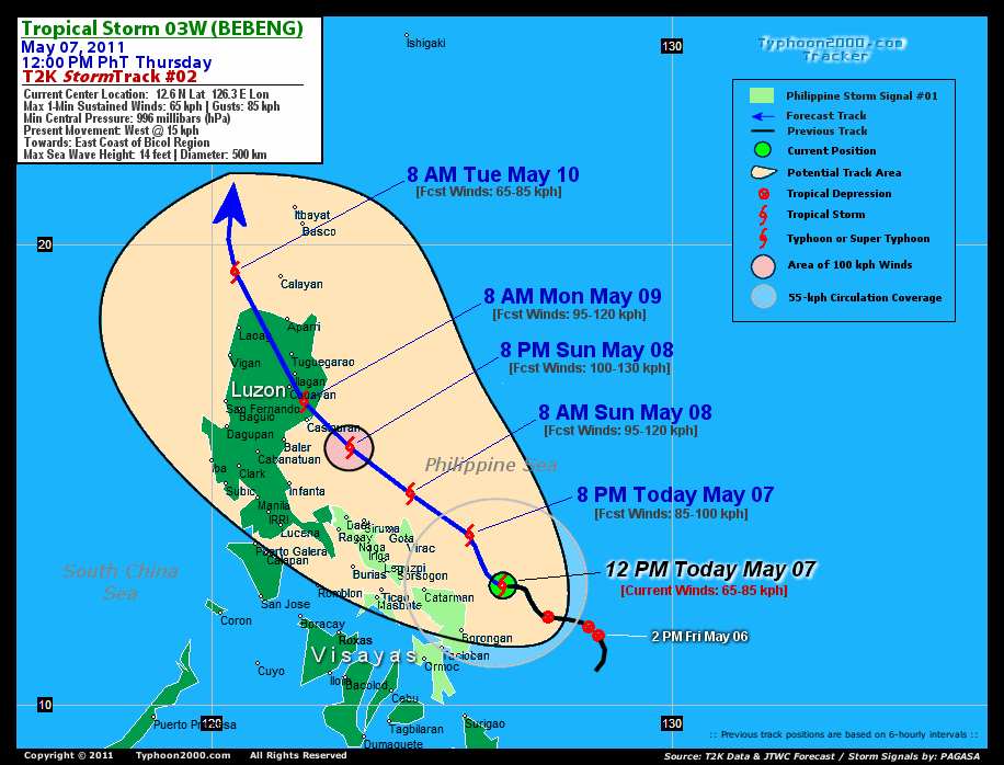
RECENT MULTI-AGENCY TROPICAL CYCLONE FORECAST TRACKING CHART:

> Image source: NOAA SATELLITE CENTER: http://www.ssd.noaa.gov/mtsat/flt/t1/rgb.jpg
> Image source: Wunderground.com Tropical Page (http://www.wunderground.com/tropical)
____________________________________________________________________________________________________________________
LATEST 24 HR. TOTAL RAINFALL AMOUNTS / ENSEMBLE TROPICAL RAINFALL POTENTIAL (eTRaP):

> Image source: NOAA Satellite & Information Service (http://www.ssd.noaa.gov/PS/TROP/etrap.html)
>> To know the meteorological terminologies and acronyms used on this update visit the ff:
http://typhoon2000.ph/tcterm.htm
http://www.nhc.noaa.gov/aboutgloss.shtml
http://www.srh.noaa.gov/oun/severewx/glossary.php
http://www.srh.weather.gov/fwd/glossarynation.html
http://www.nhc.noaa.gov/acronyms.shtml
__________________________________________________________________________________________
For the complete details on TS 03W (BEBENG)...go visit our website @:
> http://www.typhoon2000.com
> http://www.maybagyo.com
Copyright © 2011 Typhoon2000.com All Rights Reserved

No comments:
Post a Comment