
for Saturday, 07 May 2011 [6:21 PM PhT]![]()

<<<Typhoon2000.com Mobile >>>
Get the latest 3-Hourly SMS Storm Alerts on BEBENG!
For more details: Text T2K TYPHOON to
2800 (Globe/TM) | 216 (Smart/TNT) | 2288 (Sun)
*only P2.50 (Smart/Globe) / P2.00 (Sun) per msg received.
powered by: Synermaxx
Typhoon2000 (T2K) NEWS (Saturday May 07 2011):
Now issuing 3-hrly web and e-mail updates (except 12 AM) on TS AERE (BEBENG) as it nears Bicol Area.
AERE (BEBENG) MAX WIND SPEED PER AGENCY:
+ USA (JTWC/1-min avg): 65 km/hr
+ Japan (JMA/10-min avg): 65 km/hr
+ Philippines (PAGASA/10-min avg): 65 km/hr
+ Beijing (NMC/2-min avg): 65 km/hr
:: Click here to see Multi-Agency Forecast Tracks
TROPICAL STORM AERE [BEBENG/03W/1101]
T2K PUBLIC ADVISORY NUMBER 004
6:00 PM PhT (10:00 GMT) Sat 07 May 2011
Sources: T2K Extrap Analysis/JTWC Warning #005/SatFixes
View: Advisory Archives (2004-2011)
Tropical Storm AERE (BEBENG) now passing close to the coast of Northern Samar and has moved slowly WNW-ward during the past 3 hours - increasing its threat to Bicol Region. Its western rainbands continues to dump moderate to heavy rains across the Bicol Region and Eastern Visayas. Flash floods & landslides imminent on hazard risk areas.
Residents and visitors along Eastern Luzon, Bicol Region and Eastern Visayas should closely monitor the progress of AERE (BEBENG).
Do not use this for life or death decision. This advisory is intended for additional information purposes only. Kindly refer to your country's official weather agency for local warnings, advisories & bulletins.
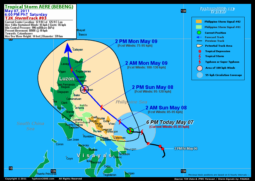
CURRENT STORM INFORMATION
Time/Date: 6:00 PM PhT Sat May 07 2011
Location of Center: 12.9º N Lat 125.9º E Lon
Distance 1: 150 km (80 nm) ENE of Catarman, N.Samar
Distance 2: 200 km (108 nm) SE of Virac, Catanduanes
Distance 3: 205 km (110 nm) East of Sorsogon City
Distance 4: 240 km (130 nm) ESE of Legazpi City
Distance 5: 250 km (135 nm) SE of Gota Beach
Distance 6: 275 km (148 nm) ESE of Iriga City
Distance 7: 300 km (162 nm) ESE of Metro Naga/CWC
Distance 8: 305 km (165 nm) SE of Siruma, CamSur
Distance 9: 350 km (188 nm) ESE of Daet/Ragay
Distance 10: 550 km (297 nm) SE of Metro Manila
MaxWinds (1-min avg): 65 kph (35 kts) near the center
Peak Wind Gusts: 85 kph (45 kts)
Present Movement: WNW @ 10 kph (05 kts)
Towards: Catanduanes
CPA over Bicol Area: 2AM-2PM Sunday
24hr Total Rainfall (near center): 460 mm (Very Heavy)
Minimum Central Pressure: 996 millibars (hPa)
Saffir-Simpson Typhoon Scale: TS
Size (in Diameter): 370 km (180 nm) / Average
Max Sea Wave Height (near center): 14 ft (4.2 m)
Possible Storm Surge Height: 0-3 ft [0-0.9 m]
T2K TrackMap (for Public): 12:00 PM PhT Sat May 07
FORECAST OUTLOOK ANALYSIS (up to 48 hours)* EXTENDED FORECAST TRACK (3 to 5 days)*
AERE (BEBENG) is expected to resume and maintain its NW-ward track for the next 2 days and will continue to intensify while moving closer towards the eastern coast of Bicol Peninsula. This system shall pass very close to the Northern tip of Catanduanes tomorrow morning (Sun May 08) between 7-8AM...or about 60 km to the NNE of Virac, Catanduanes or about 140 km ENE of Metro Naga. Its Closest Point of Approach (CPA) to Metro Naga shall be more or less 125 km to the NE of the city around 10AM tomorrow [2AM MAY 08: 13.6N 125.1E @ 85 kph...2PM MAY 08: 14.7N 123.7E @ 95kph]. By early Monday morning (May 9), AERA shall be reaching its peak strength of 100 kph while off the coast of Aurora...about 35 km ESE of Casiguran, Aurora. It shall make landfall just to the NE of Casiguran, Aurora between 3-4AM (Monday May 09)...about 15 km NE of Casiguran, and cross Northern Luzon, passing between the town of Cauayan & Ilagan City around 8-9AM (Monday May 09). By Monday afternoon, AERE shall be off Kalinga-Apayao Area...about 30 km WSW of Tugguegarao City, Cagayan [2AM MAY 09: 16.1N 122.4E @ 100kph...2PM MAY 09: 17.6N 121.4E @ 75kph].
Maximum Sustained Winds (1-min. avg) are near 65 km/hr (35 knots) with higher gusts. AERE (BEBENG) is a Tropical Storm on the Saffir-Simpson Tropical Cyclone Scale. Further strengthening is expected tonight as it moves closer to Bicol Region.  TUESDAY AFTERNOON: Weakening gradually after crossing Northern Luzon...shall be over the Bashi Channel...about 85 km WNW of Basco, Batanes [2PM MAY 10: 20.7N 121.1E @ 65kph]. WEDNESDAY AFTERNOON: Downgraded to a Tropical Depression (TD) as it recurves NE-ward, passing near the east coast of Taiwan...about 120 km SE of Hualien City, Taiwan [2PM MAY 11: 23.3N 122.5E @ 55kph]. THURSDAY AFTERNOON: Accelerating NE-ward as it exits the Philippine Area of Responsibility (PAR)...about 270 km West of Okinawa Island, Japan [2PM MAY 12: 26.6N 125.3E @ 55kph].
*Please be reminded that the Forecast Outlook changes every 6 hours, and the Extended Forecast Track have an average error of 250 km on Day 3...450 km on Day 4...and 650 km on Day 5, while the wind speed forecast error, averages 35 kph per day. Therefore, a turn to the left or right of its future track and changes in its wind speed must be anticipated from time to time.
EFFECTS & HAZARDS SUMMARY
AERE's circulation continues to slowly organize while over water (South Philippine Sea, near the coast of Northern Samar) w/ its improved rainbands affecting the Bicol Region, Southern Quezon, Visayas, Northeastern Mindanao & nearby areas. Below are the summary of the storm's parts and its hazards affecting specific areas: INNER RAINBANDS - affecting Samar Provinces, Catanduanes, Sorsogon...& expected to reach the rest of Bicol Region later tonight until tomorrow. Tropical Storm Conditions w/ Tropical Storm Force Winds (65-85 kph) can be expected along these bands. OUTER RAINBANDS - spreading across the Bicol Region, Masbate, Rest of Visayas, Eastern Mindoro, Marinduque, & Southern Quezon - where light to moderate winds (<60 kph) can be expected along these bands. (click here to know more about Rainbands). 24HR TOTAL RAINFALL ACCUMULATION - from 5 up to 300 mm (light to heavy rain) can be expected along the outer & inner rainbands...with isolated amounts of up to 460 mm (very heavy) near the center of 03W. [click to open NOAA's eTRaP graphic].
TROPICAL CYCLONE WATCH CURRENT ITCZ/MONSOON TROUGH INTENSITY: MODERATE >> Partly sunny to mostly cloudy with scatt$ered showers, rains & thunderstorms can be expected along these following affected areas: PALAWAN, MINDANAO & SOUTHERN LUZON. Light to moderate NW, W, SW to variable winds (not in excess of 35 kph) can be expected today and tomorrow.
Tropical Disturbance 94W (LPA/1010 MB) remains a very system over the Caroline Islands just north of the Equator, south of Guam. The ill-defined center was located near lat 2.5N lon 143.5E...about 1130 km SE of Palau Islands or 1950 km SE of Mindanao, PH...with 1-min maximum sustained winds of 30 kph near the center...moving WNW @ 15 kph. The 48-Hr. Tropical Cyclone Formation Potential on this system remains @ 30%. Click here to view current satellite image and flash animation.
Important Note: Please keep in mind that the above forecast outlook, extended forecast, effects-hazards, current monsoon intensity, & tropical cyclone watch changes every 6 to 12 hrs!![]()
PAGASA Philippine Storm Warnings Signals
PHILIPPINE STORM WARNING SIGNAL # TWO (2) 
Now In Effect: CATANDUANES, CAMARINES SUR, ALBAY, SORSOGON, & NORTHERN SAMAR.
The above areas will experience stormy weather tonight & tomorrow (with winds not exceeding 85 kph). Coastal waters will be rough to very rough and extremely dangerous to all types of seacrafts. PHILIPPINE STORM WARNING SIGNAL # ONE (1) The above areas will have rains and winds of not more than 60 kph tonight until tomorrow. Coastal waters will be moderate to rough.
In Effect: MASBATE, TICAO & BURIAS ISLANDS, CAMARINES NORTE, QUEZON, POLILLO ISLANDS, AURORA, MARINDUQUE, EASTERN & WESTERN SAMAR.
Residents living in low-lying and mountainous areas under Public Storm Warning Signal Number 1 & 2 are alerted against possible flashfloods, mudslides and landslides...while those living in coastal & beach-front areas are advised to seek higher grounds due to possible storm surge (aka. big waves).
JTWC (US NAVY & AIR FORCE) REMARKS:
REMARKS (for Meteorologists): 2 PM (06 GMT) SAT 07 MAY POSITION: 12.8N 126.3E.
*ANIMATED MULTISPECTRAL IMAGERY (MSI) REVEALS DEEP CONVECTION
DEVELOPED OVER THE LOW LEVEL CIRCULATION CENTER (LLCC). THE INITIAL
POSITION IS BASED ON THE MSI WITH LOW CONFIDENCE. THE INITIAL
INTENSITY IS BASED ON PGTW AND KNES DVORAK ESTIMATES OF 35 KNOTS.
WATER VAPOR IMAGERY DEPICTS IMPROVED RADIAL OUTFLOW, WITH A POLEWARD
OUTFLOW CHANNEL BEGINNING TO DEVELOP. THE SYSTEM IS LOCATED JUST
SOUTH OF AN UPPER LEVEL ANTICYCLONE IN AN AREA WITH LOW VERTICAL
WIND SHEAR (VWS). TS 03W IS CURRENTLY TRACKING ALONG THE
SOUTHWESTERN PERIPHERY OF A LOW- TO MID-LEVEL STEERING RIDGE AND IS
EXPECTED TO CONTINUE TRACKING GENERALLY NORTHWESTWARD, MAKING
LANDFALL OVER LUZON JUST AFTER TAU 36. THE STEERING RIDGE WILL THEN
BEGIN TO WEAKEN WITH A PASSING MID-LATITUDE TROUGH AND ALLOW TS AERE
TO TURN POLEWARD. TS AERE IS EXPECTED TO ROUND THE RIDGE AXIS AFTER
TAU 72 AS IT PASSES SOUTH OF TAIWAN. THE SYSTEM SHOULD CONTINUE TO
INTENSIFY DUE TO FAVORABLE OUTFLOW, LOW VWS, AND HIGH SEA SURFACE
TEMPERATURES (>28 DEGREES CELSIUS). AFTER MAKING LANDFALL OVER THE
RUGGED TERRAIN OF LUZON, IT WILL SIGNIFICANTLY WEAKEN AND RE-EMERGE
OVER THE STRAIGHT OF LUZON AS A WEAK TS. INCREASING VWS ASSOCIATED
WITH THE MID-LATITUDE WESTERLIES AND DRY AIR ENTRAINMENT IS EXPECTED
TO PREVENT FURTHER INTENSIFICATION AS IT RE-EMERGES OVER THE
STRAIGHT OF LUZON. NUMERICAL MODEL GUIDANCE IS IN FAIR AGREEMENT
WITH THE POLEWARD TRACK. HOWEVER, JGSM AND GFS SLOWLY TRACK THE
SYSTEM POLEWARD ACROSS THE STRAIGHT OF LUZON, WHILE NOGAPS, UKMO,
ECMWF, AND GFDN RECURVE AND SPEED UP THE SYSTEM AROUND TAU 72. THIS
FORECAST FAVORS A FASTER TRACK IN THE LATER TAUS DUE TO INTERACTION
WITH THE MID-LATITUDES...(more)
>> AERE, meaning: A storm. Name contributed by: United States of America.
_______________________________________________________________________________________________________________________________________
RECENT TYPHOON2000.COM TRACKING CHART:
RECENT MULTI-AGENCY TROPICAL CYCLONE FORECAST TRACKING CHART:


> Image source: NOAA SATELLITE CENTER: http://www.ssd.noaa.gov/mtsat/flt/t1/rgb.jpg
> Image source: Wunderground.com Tropical Page (http://www.wunderground.com/tropical)
____________________________________________________________________________________________________________________
LATEST 24 HR. TOTAL RAINFALL AMOUNTS / ENSEMBLE TROPICAL RAINFALL POTENTIAL (eTRaP):

> Image source: NOAA Satellite & Information Service (http://www.ssd.noaa.gov/PS/TROP/etrap.html)
>> To know the meteorological terminologies and acronyms used on this update visit the ff:
http://typhoon2000.ph/tcterm.htm
http://www.nhc.noaa.gov/aboutgloss.shtml
http://www.srh.noaa.gov/oun/severewx/glossary.php
http://www.srh.weather.gov/fwd/glossarynation.html
http://www.nhc.noaa.gov/acronyms.shtml
__________________________________________________________________________________________
For the complete details on TS AERE (BEBENG)...go visit our website @:
> http://www.typhoon2000.com
> http://www.maybagyo.com
Copyright © 2011 Typhoon2000.com All Rights Reserved

No comments:
Post a Comment