
for Monday, 09 May 2011 [12:26 PM PhT]![]()

<<<Typhoon2000.com Mobile >>>
Get the latest 3-Hourly SMS Storm Alerts on BEBENG!
For more details: Text T2K TYPHOON to
2800 (Globe/TM) | 216 (Smart/TNT) | 2288 (Sun)
*only P2.50 (Smart/Globe) / P2.00 (Sun) per msg received.
powered by: Synermaxx
Typhoon2000 (T2K) NEWS (Saturday May 07 2011):
Currently issuing 3-hrly web and e-mail updates (except 12 AM & 3 AM) on TS AERE (BEBENG).
AERE (BEBENG) MAX WIND SPEED PER AGENCY:
+ USA (JTWC/1-min avg): 85 km/hr
+ Japan (JMA/10-min avg): 85 km/hr
+ Philippines (PAGASA/10-min avg): 75 km/hr
+ Beijing (NMC/2-min avg): 85 km/hr
+ Korea (KMA/10-min avg): 75 km/hr
+ Taiwan (CWB/10-min avg): 85 km/hr
+ Hong Kong (HKO/10-min avg): 85 km/hr
:: Click here to see Multi-Agency Forecast Tracks
TROPICAL STORM AERE [BEBENG/03W/1101]
T2K PUBLIC ADVISORY NUMBER 011
12:00 PM PhT (04:00 GMT) Mon 09 May 2011
Sources: T2K Extrap Analysis/JTWC Warning #012/SatFixes
View: Advisory Archives (2004-2011)
Tropical Storm AERE (BEBENG) has jogged slightly NW-ward and made landfall over Isabela...now approaching the City of Ilagan...expected to cross Cagayan this afternoon.
Residents and visitors along Northern & Central Luzon should closely monitor the progress of AERE (BEBENG).
Do not use this for life or death decision. This advisory is intended for additional information purposes only. Kindly refer to your country's official weather agency for local warnings, advisories & bulletins.
CURRENT STORM INFORMATION FORECAST OUTLOOK ANALYSIS (up to 48 hours)* EXTENDED FORECAST TRACK (3 to 4 days)* EFFECTS & HAZARDS SUMMARY CURRENT ENHANCED SW MONSOON INTENSITY: STRONG >> Cloudy with scattered to widespread showers, rains & thunderstorms can be expected along these following affected areas: REST OF BICOL REGION, MINDORO, MARINDUQUE, ROMBLON, VISAYAS, AND MINDANAO. Light to moderate SW'ly winds (not in excess of 35 kph) will be expected today.
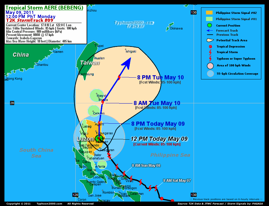
Time/Date: 12:00 PM PhT Mon May 09 2011
Location of Center: 17.0º N Lat 122.0º E Lon
Distance 1: 30 km (17 nm) SE of Ilagan City
Distance 2: 35 km (19 nm) ENE of Cauayan, Isabela
Distance 3: 75 km (40 nm) SSE of Tuguegarao City
Distance 4: 90 km (48 nm) North of Casiguran, Aurora
Distance 5: 160 km (85 nm) SSE of Aparri, Cagayan
Distance 6: 285 km (155 nm) NNE of Metro Manila
Distance 7: 400 km (217 nm) NNW of Metro Naga/CWC
MaxWinds (1-min avg): 85 kph (45 kts) near the center
Peak Wind Gusts: 100 kph (55 kts)
Present Movement: NNW @ 17 kph (09 kts)
Towards: Isabela-Cagayan Area
CPA over Isabela-Cagayan: 6AM-6PM Today
06-12hr Total Rainfall (near center): 100 mm (Heavy)
Minimum Central Pressure: 989 millibars (hPa)
Saffir-Simpson Typhoon Scale: TS
Size (in Diameter): 405 km (220 nm) / Average
Max Sea Wave Height (near center): 18 ft (5.4 m)
Possible Storm Surge Height: 0-3 ft [0-0.9 m]
T2K TrackMap (for Public): 12:00 PM PhT Mon May 09
AERE (BEBENG) is expected to maintain its NNW-ward track for the next 06-12 hours, and make landfall along Eastern Aurora this morning (approx 9-11AM)...and will cross Eastern Cagayan, passing to the east of Tuguegarao City around 2PM today. TS AERE will exit Cagayan around 8PM tonight...about 35 km East of Aparri and shall track across Balintang Channel by early tomorrow morning (2AM) - just to the east of Calayan Island. It shall pass close to Batanes Islands around 8AM tomorrow, May 10 - as the storm starts to recurve towards the NE in the direction of the Southern Islands of Japan. [8PM MAY 09: 18.3N 122.0E @ 75kph...8AM MAY 10: 20.1N 122.3E @ 85kph]...8PM MAY 10: 22.2N 123.7E @ 85kph...8AM MAY 11: 24.5N 126.0E @ 85kph.
Maximum Sustained Winds (1-min. avg) are near 95 km/hr (50 knots) with higher gusts. AERE (BEBENG) is a strong Tropical Storm on the Saffir-Simpson Tropical Cyclone Scale. Tropical Storm Force Winds (62-117 km/hr) extend outward up to 220 kilometers (120 nautical miles) from the center. AERE is an average-sized tropical cyclone with a diameter of 405 kilometers (220 nautical miles).  THURSDAY MORNING: Becoming Extratropical...accelerating ENE after passing Okinawa & Ryukyu Islands...about 285 km ENE of Naje Island [8AM MAY 12: 29.4N 132.6E @ 75kph]. FRIDAY MORNING: Attains Extratropical status as it zooms past to the south of Honshu, Japan in the NW Pacific...about 330 km ESE of Tokyo. [8AM MAY 13: 34.7N 143.1E @ 65kph].
*Please be reminded that the Forecast Outlook changes every 6 hours, and the Extended Forecast Track have an average error of 250 km on Day 3...450 km on Day 4...and 650 km on Day 5, while the wind speed forecast error, averages 35 kph per day. Therefore, a turn to the left or right of its future track and changes in its wind speed must be anticipated from time to time.
AERE's circulation has shrunk as it passes along Northeastern Luzon. Below are the summary of the storm's parts and its hazards affecting specific areas: CENTRAL DENSE OVERCAST (CDO) - in the vicinity of Southern & Eastern Isabela...expected to reach Eastern & NE Cagayan later this afternoon. Tropical Storm Conditions w/ Tropical Storm Force Winds (62-117 kph) will be expected along the CDO. (click here to know more about CDO). INNER RAINBANDS - affecting Aurora, & Rest of Isabela. Tropical Depression Conditions w/ moderate to strong winds (30-61 kph) will be expected along these bands. OUTER RAINBANDS - spreading across portions of Northern & Central Luzon including Metro Manila & Southern Tagalog Provinces and Northern Bicol - where light to moderate winds (<30 kph) will be expected along these bands. (click here to know more about Rainbands). 06-12HR TOTAL RAINFALL ACCUMULATION - from 5 up to 50 mm (light to moderate rain) can be expected along the outer & inner rainbands...with isolated amounts of up to 100 mm (moderate-heavy) near the center of AERE. [click to open NOAA's eTRaP graphic].
Important Note: Please keep in mind that the above forecast outlook, extended forecast, effects-hazards, current monsoon intensity, & tropical cyclone watch changes every 6 to 12 hrs!![]()
PAGASA Philippine Storm Warnings Signals
PHILIPPINE STORM WARNING SIGNAL # TWO (2) 
In Effect: AURORA, ISABELA, QUIRINO, NUEVA VISCAYA, IFUGAO, MT. PROVINCE, KALINGA, CAGAYAN.
The above areas will experience stormy weather today (with winds not exceeding 100 kph). Coastal waters will be rough to very rough and extremely dangerous to all types of seacrafts. PHILIPPINE STORM WARNING SIGNAL # ONE (1) The above areas will have rains and winds of not more than 60 kph today. Coastal waters will be moderate to rough.
In Effect: NORTHERN QUEZON, POLILLO, NUEVA ECIJA, BENGUET, ILOCOS SUR, ILOCOS NORTE, ABRA, APAYAO, BABUYAN-CALAYAN-BATANES GROUP OF ISLANDS.
Residents living in low-lying and mountainous areas under Public Storm Warning Signal Number 1 & 2 are alerted against possible flashfloods, mudslides and landslides...while those living in coastal & beach-front areas are advised to seek higher grounds due to possible storm surge (aka. big waves).
JTWC (US NAVY & AIR FORCE) REMARKS:
REMARKS (for Meteorologists): 8 AM (00 GMT) MON 09 MAY POSITION: 16.5N 122.5E.
*TROPICAL STORM (TS) 03W (AERE), LOCATED APPROXIMATELY 145 NM
NORTHEAST OF MANILA, PHILIPPINES, HAS TRACKED NORTH-NORTHWESTWARD AT
09 KNOTS OVER THE PAST SIX HOURS. ANIMATED MULTI-SPECTRAL SATELLITE
IMAGERY (MSI) AND A 082200Z SSMIS MICROWAVE IMAGE SHOW TIGHTLY
CURVED LOW LEVEL BANDING WRAPPING INTO A WELL-DEFINED LOW LEVEL
CIRCULATION CENTER (LLCC) WITH DEEP CONVECTION BEGINNING TO RE-BUILD
OVER THE CENTER. THE INTENSITY IS BASED ON DVORAK CURRENT INTENSITY
(CI) ESTIMATES FROM PGTW AND KNES OF 45 KNOTS. THERE IS FAIR
CONFIDENCE IN THE CURRENT POSITION BASED ON MSI AND THE
AFOREMENTIONED MICROWAVE IMAGE. TS 03W IS CURRENTLY MAKING LANDFALL
OVER THE NORTHEASTERN LUZON COAST AND IS EXPECTED TO CONTINUE TO
SKIRT THE COAST AS IT ROUNDS THE SUBTROPICAL RIDGE AXIS. UPPER LEVEL
ANALYSIS INDICATES THAT THE SYSTEM REMAINS WITHIN A REGION OF LOW
VERTICAL WIND SHEAR (VWS) AND STRONG DIFFLUENCE ALOFT. ANIMATED
WATER VAPOR IMAGERY INDICATES THAT THE POLEWARD OUTFLOW CHANNEL
REMAINS SOMEWHAT ENHANCED BY A PASSING MID-LATITUDE TROUGH.
EQUATORWARD OUTFLOW HAS WEAKENED SLIGHTLY OVER THE PAST 12 HOURS...(more)
>> AERE, meaning: A storm. Name contributed by: United States of America.
_______________________________________________________________________________________________________________________________________
RECENT TYPHOON2000.COM TRACKING CHART:
RECENT MULTI-AGENCY TROPICAL CYCLONE FORECAST TRACKING CHART:


> Image source: NOAA SATELLITE CENTER: http://www.ssd.noaa.gov/mtsat/flt/t1/rgb.jpg
> Image source: Wunderground.com Tropical Page (http://www.wunderground.com/tropical)
____________________________________________________________________________________________________________________
LATEST 06-12 HR. TOTAL RAINFALL AMOUNTS / ENSEMBLE TROPICAL RAINFALL POTENTIAL (eTRaP):

> Image source: NOAA Satellite & Information Service (http://www.ssd.noaa.gov/PS/TROP/etrap.html)
>> To know the meteorological terminologies and acronyms used on this update visit the ff:
http://typhoon2000.ph/tcterm.htm
http://www.nhc.noaa.gov/aboutgloss.shtml
http://www.srh.noaa.gov/oun/severewx/glossary.php
http://www.srh.weather.gov/fwd/glossarynation.html
http://www.nhc.noaa.gov/acronyms.shtml
__________________________________________________________________________________________
For the complete details on TS AERE (BEBENG)...go visit our website @:
> http://www.typhoon2000.com
> http://www.maybagyo.com
Copyright © 2011 Typhoon2000.com All Rights Reserved

No comments:
Post a Comment