
for Wednesday, 25 May 2011 [7:07 PM PhT]![]()

<<<Typhoon2000.com Mobile >>>
Get the latest 3-hrly SMS Storm Alerts on CHEDENG!
For more details: Text T2K TYPHOON to
2800 (Globe/TM) | 216 (Smart/TNT) | 2288 (Sun)
*Only P2.50 (Smart/Globe) / P2.00 (Sun) per msg received.
Click here on how to use this service (in PDF file)
Powered by: Synermaxx Corporation
Typhoon2000 (T2K) NEWS (Wednesday May 25 2011):
Now issuing 3-hrly web, twitter, SMS and e-mail updates on TY SONGDA (CHEDENG).
SONGDA (CHEDENG) MAX WIND SPEED PER AGENCY:
+ USA (JTWC/1-min avg): 195 km/hr
+ Philippines (PAGASA/10-min avg): 130 km/hr
+ Japan (JMA/10-min avg): 165 km/hr
+ Korea (KMA/10-min avg): 150 km/hr
+ Taiwan (CWB/10-min avg): 160 km/hr
+ Beijing (NMC/2-min avg): 160 km/hr
+ Hong Kong (HKO/10-min avg): 130 km/hr
:: Click here to see Multi-Agency Forecast Tracks
TYPHOON SONGDA [CHEDENG/04W/1102]
T2K PUBLIC ADVISORY NUMBER 018
6:00 PM PhT (10:00 GMT) Wed 25 May 2011
Sources: T2K Extrap Analysis/JTWC Warning #021/SatFixes
View: Advisory Archives (2004-2011)
Typhoon SONGDA (CHEDENG) continues to intensify and is now at Category 3...turning more towards the NNW, lessening its threat across the Bicol Region. Outer rain bands continues to spread across Eastern Visayas and Bicol Region
Residents and visitors along the Eastern Luzon, Bicol Region & Eastern Visayas should closely monitor the progress of SONGDA (CHEDENG).
Do not use this for life or death decision. This advisory is intended for additional information purposes only. Kindly refer to your country's official weather agency for local warnings, advisories & bulletins.
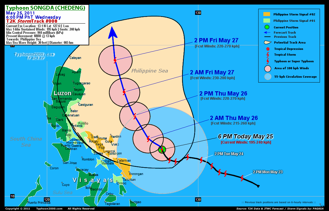
CURRENT STORM INFORMATION
Time/Date: 6:00 PM PhT Wed May 25 2011
Location of Eye: 13.1º N Lat 127.6º E Lon
Distance 1: 320 km (173 nm) ENE of Catarman, N.Samar
Distance 2: 370 km (200 nm) ESE of Virac, Catanduanes
Distance 3: 390 km (210 nm) East of Sorsogon City
Distance 4: 420 km (227 nm) East of Legazpi City
Distance 5: 455 km (245 nm) ESE of Iriga City
Distance 6: 480 km (260 nm) ESE of Metro Naga/CWC
Distance 7: 520 km (280 nm) ESE of Daet, CamNorte
MaxWinds (1-min avg): 195 kph (105 kts) near the center
Peak Wind Gusts: 240 kph (130 kts)
Present Movement: NNW @ 13 kph (07 kts)
Towards: Philippine Sea
CPA near Bicol Coast: 2AM-2PM Tomorrow
24hr Rainfall Accum (near center): 320 mm (High)
Rainrate (near center): 25-30 mm/hr (Mod-Heavy)
Minimum Central Pressure: 944 millibars (hPa)
Saffir-Simpson Typhoon Scale: Category 3
Size (in Diameter): 665 km (360 nm) / Average
Max Sea Wave Height (near center): 30 ft (9.1 m)
Possible Storm Surge Height: 9-12 ft [2.7-3.9 m]
T2K TrackMap (for Public): 12:00 PM PhT Wed May 25
FORECAST OUTLOOK ANALYSIS (up to 2 days)* SONGDA's CLOSEST POINT OF APPROACH (CPA)* EXTENDED FORECAST TRACK (3 to 5 days)* EFFECTS & HAZARDS SUMMARY
SONGDA (CHEDENG) is expected to continue intensifying and shall resume its NW track across the Philippine Sea, east of Luzon within the next 2 days. The typhoon is likely to pass more or less 300 km to the ENE of Bicol Region by early tomorrow morning & shall be reaching Category 4 strength. TOMORROW EARLY MORNING (THU): Upgraded to Category 4 as it turns back to the NW...about 260 km East of Guigmoto, Catanduanes [2AM MAY 26: 13.8N 126.7E @ 215kph]. TOMORROW AFTERNOON (THU): Starting to move farther away from Catanduanes...about 220 km NE of Pandan, Catanduanes [2PM MAY 26: 15.3N 125.8E @ 220kph]. FRIDAY EARLY MORNING: At near-Super Typhoon strength as it turns more NNW-ward...about 275 km East of Palanan Bay, Isabela [2AM MAY 27: 16.9N 125.1E @ 230kph]. FRIDAY AFTERNOON: Starts to decay slowly as it turns more Northerly while moving across the Northern Philippine Sea...about 315 km East of Calayan Island (Balintang Channel) [2PM MAY 27: 19.0N 124.5E @ 220kph].
Maximum Sustained Winds (1-min. avg) have increased to near 195 km/hr (105 knots) with higher gusts. SONGDA (CHEDENG) is now a Category 3 Typhoon on the Saffir-Simpson Tropical Cyclone Scale. Typhoon Force Winds (118 km/hr or more) extend outward up to 65 kilometers (35 nautical miles) from the center...and Tropical Storm Force Winds (62-117 km/hr) extend outward up to 215 kilometers (115 nautical miles). SONGDA is an average-sized tropical cyclone with a diameter of 665 kilometers (360 nautical miles). CATANDUANES: about 215 km NE of Pandan or 250 km NE of Virac [between 8:00-11:00 AM Tomorrow]. CAMARINES SUR: about 270 km ENE of Caramoan or 340 km ENE of Metro Naga [between 9:00-11:00 AM Tomorrow]. ALBAY: about 315 km ENE of Legazpi City [between 2:00-4:00 AM Tomorrow]. SORSOGON: about 290 km ENE of Sorsogon City [between 2:00-4:00 AM Tomorrow].
SATURDAY AFTERNOON: Recurves towards the NNE as it moves out of the Philippine Area of Responsibility (PAR)...approaching Okinawa Island [2PM MAY 28: 24.2N 126.0E @ 195kph]. SUNDAY AFTERNOON: Accelerating ENE-ward while passing to the south of Kyushu, Japan...becoming Extratropical [2PM MAY 29: 30.0N 132.4E @ 150kph]. MONDAY AFTERNOON: Attains Extratropical status while accelerating ENE-ward across the North Pacific Ocean [2PM MAY 30: 33.8N 144.2E @ 95kph].
*Please be reminded that the Forecast Outlook changes every 6 hours, and the Extended Forecast Track have an average error of 250 km on Day 3...450 km on Day 4...and 650 km on Day 5, while the wind speed forecast error, averages 35 kph per day. Therefore, a turn to the left or right of its future track and changes in its wind speed must be anticipated from time to time.
SONGDA's circulation improving as the system slows down...irregular eye can now be seen on satellite imageries. Below are the summary of the typhoon's parts and its hazards affecting specific areas: CLOUD-FILLED EYE - still over water (Philippine Sea)...not affecting any land areas. Possible calm and lull conditions (with <20 kph winds) can be expected inside the eye (click here to know more about the EYE). EYEWALL - still over water (Philippine Sea)...not affecting any land areas. Typhoon Conditions with typhoon force winds (>118 kph) can be expected within this wall (click here to know more about the Eyewall). INNER RAINBANDS - still over water...not affecting any land areas. Tropical Storm Conditions w/ Tropical Storm Force Winds (65-117 kph) can be expected along these bands. OUTER RAINBANDS - spreading across the Bicol Region, Masbate, & Eastern Visayas. Tropical Depression Conditions w/ moderate to strong winds (30-61 kph) can be expected along these bands (click here to know more about Rainbands). 24HR TOTAL RAINFALL ACCUMULATION - from 5 up to 200 mm (low to high rainfall) can be expected along the outer & inner rainbands...with isolated amounts of up to 320 mm (high) near the center of SONGDA. [click to open NOAA's eTRaP graphic]. COASTAL STORM SURGE FLOODING - possible 9 to 12 feet above normal tide levels...accompanied by large and dangerous battering waves can be expected along the coastal and beach front areas of Bicol Region & Samar Provinces tonight until tomorrow. Extensive damage is likely on this type of storm surge. Danger from Rip Currents or Rip Tides can be expected along the beach-front areas of Eastern Visayas and Eastern Luzon tonight until tomorrow. (click here to know more about Storm Surge).
CURRENT SW MONSOON INTENSITY: MODERATE >> Mostly cloudy with occasional squalls, rains & thunderstorms can be expected along the following affected areas: PALAWAN & WESTERN MINDANAO. Light to moderate SW to Westerly winds (not in excess of 40 kph) will blow.
Important Note: Please keep in mind that the above forecast outlook, extended forecast, effects-hazards, current monsoon intensity, & tropical cyclone watch changes every 6 to 12 hrs!
JTWC (US NAVY & AIR FORCE) REMARKS:
REMARKS (for Meteorologists): 2 PM (06 GMT) WED 25 MAY POSITION: 12.7N 127.8E.
*TYPHOON (TY) 04W (SONGDA), LOCATED APPROXIMATELY 410 NM EAST-
SOUTHEAST OF MANILA, PHILIPPINES, HAS TRACKED NORTHWESTWARD AT
06 KNOTS OVER THE PAST SIX HOURS. ANIMATED MULTISPECTRAL IMAGERY
(MSI) SHOWS A CLEAR RESUMPTION OF NORTHWESTWARD MOVEMENT DURING THE
PAST SIX HOURS, AFTER A NEARLY 18 HOUR PERIOD OF WESTWARD MOVEMENT.
POSITION CONFIDENCE IS HIGH BASED ON AN EYE FIX USING MSI AND HIGH
RESOLUTION VISUAL IMAGERY. THE PGTW SUBJECTIVE DVORAK ANALYSIS USING
THE EYE TECHNIQUE RESULTED IN AN INTENSITY ESTIMATE OF 115 KTS.
DOVRAK ESTIMATES FROM KNES AND RJTD THREE HOURS PRIOR TRANSLATE TO
AN INTENSITY OF 90 KTS. THE CURRENT INTENSITY ASSESSMENT IS AN
AVERAGE OF THE 3 AGENCY DVORAK ESTIMATES. REGARDLESS OF THE
VARIATION IN INTENSITY ESTIMATES, SATELLITE ANIMATION SHOWS A
SIGNIFICANT INTENSIFICATION AND CONSOLIDATION OF CONVECTION AROUND
THE LOW LEVEL CIRCULATION CENTER. ALTHOUGH NO CLEAR OUTFLOW CHANNELS
HAVE DEVELOPED, WATER VAPOR ANIMATION REVEALS IMPROVING OUTFLOW,
ESPECIALLY OVER THE NORTHWEST QUADRANT OF THE SYSTEM. THE RECENT
SURGE IN INTENSITY IS NOT SURPRISING GIVEN THE 30-31 DEGREE SEA
WATER AND WEAK VERTICAL WIND SHEAR (5-10 KTS) OVER THE PHILIPPINE
SEA. TY 04W IS TRACKING AROUND THE WESTERN PERIMETER OF A DEVELOPING
UPPER LEVEL ANTICYCLONE. MODEL AGREEMENT HAS IMPROVED OVER THE PAST
24 HOURS, WITH EGRR AND THE JAPANESE MODEL COMING INTO LINE WITH THE
OTHER DYNAMIC AIDS. ALTHOUGH THERE IS SOME DISPARITY IN SPEED ALONG
TRACK, ALL AGREE ON A STEADY NORTHWESTWARD TRACK AROUND THE SUB-
TROPICAL RIDGE WITH CONTINUING INTENSIFICATION THROUGH 20 DEGREES
NORTH LATITUDE, FOLLOWED BY A NORTHEASTWARD TRACK AND GRADUAL
WEAKENING TREND THROUGH THE RYUKUS, AND THEN A RAPID WEAKENING TREND
NORTH OF 30 DEGREES NORTH LATITUDE AS TY 04W BEGINS EXTRA-TROPICAL
(XT) TRANSITION...(more)
>> SONGDA, meaning: A river in northwestern Viet Nam. Name contributed by:Viet Nam.
_______________________________________________________________________________________________________________________________________
RECENT TYPHOON2000.COM TRACKING CHART:
_________________________________________________________________________________________________________________
RECENT MULTI-AGENCY TROPICAL CYCLONE FORECAST TRACKING CHART: 

> Image source: NOAA SATELLITE CENTER: http://www.ssd.noaa.gov/mtsat/flt/t1/rgb.jpg
> Image source: Wunderground.com Tropical Page (http://www.wunderground.com/tropical)
____________________________________________________________________________________________________________________
LATEST 24 HR. TOTAL RAINFALL AMOUNTS / ENSEMBLE TROPICAL RAINFALL POTENTIAL (eTRaP):

> Image source: NOAA Satellite & Information Service (http://www.ssd.noaa.gov/PS/TROP/etrap.html)
>> To know the meteorological terminologies and acronyms used on this update visit the ff:
http://typhoon2000.ph/tcterm.htm
http://www.nhc.noaa.gov/aboutgloss.shtml
http://www.srh.noaa.gov/oun/severewx/glossary.php
http://www.srh.weather.gov/fwd/glossarynation.html
http://www.nhc.noaa.gov/acronyms.shtml
__________________________________________________________________________________________
For the complete details on TY SONGDA (CHEDENG)...go visit our website @:
> http://www.typhoon2000.com
> http://www.maybagyo.com
Copyright © 2011 Typhoon2000.com All Rights Reserved

No comments:
Post a Comment