
for Saturday, 18 June 2011 [12:52 PM PhT]![]()

<<<Typhoon2000.com Mobile >>>
Get the latest 3-hrly SMS Storm Alerts on EGAY!
For more details: Text T2K HELP to
2800 (Globe/TM) | 216 (Smart/TNT) | 2288 (Sun)
*Only P2.50 (Smart/Globe) / P2.00 (Sun) per msg received.
Click here on how to use this service (in PDF file)
Powered by: Synermaxx Corporation
Typhoon2000 (T2K) NEWS (Saturday June 18 2011):
Currently issuing 3-hrly web, twitter and e-mail updates (except 12:00 Midnight) on TD 06W (EGAY).
06W (EGAY) MAX WIND SPEED PER AGENCY:
+ USA (JTWC/1-min avg): 55 km/hr
+ Japan (JMA/10-min avg): 55 km/hr
+ Philippines (PAGASA/10-min avg): 55 km/hr
TROPICAL DEPRESSION 06W [EGAY]
T2K PUBLIC ADVISORY NUMBER 006
12:00 PM PhT (04:00 GMT) Sat 18 June 2011
Sources: T2K Extrap Analysis/JTWC Warning #006/SatFixes
View: Advisory Archives (2004-2011)
Tropical Depression 06W (EGAY) has drifted towards the North during the past 3 hours...its circulation has become slightly disorganized with most of its rainbands located over the Bicol Region...now threatens Extreme Northern Luzon.
Residents and visitors along the Eastern Coast of Luzon should closely monitor the progress of 06W (EGAY).
Do not use this for life or death decision. This advisory is intended for additional information purposes only. Kindly refer to your country's official weather agency for local warnings, advisories & bulletins.
CURRENT STORM INFORMATION
Time/Date: 12:00 PM PhT Sat June 18 2011
Location of Center: 14.0º N Lat 126.1º E Lon
Distance 1: 205 km (110 nm) East of Pandan, Catanduanes
Distance 2: 215 km (115 nm) ENE of Virac, Catanduanes
Distance 3: 255 km (137 nm) ENE of Sorsogon City
Distance 4: 280 km (150 nm) ENE of Legazpi City
Distance 5: 315 km (170 nm) ENE of Metro Naga/CWC
Distance 6: 345 km (185 nm) East of Daet, CamNorte
Distance 7: 480 km (260 nm) ESE of Infanta, Quezon
Distance 8: 555 km (300 nm) ESE of Metro Manila
MaxWinds (1-min avg): 55 kph (30 kts) near the center
Peak Wind Gusts: 75 kph (40 kts)
Present Movement: North @ 19 kph (10 kts)
Towards: Extreme Northern Luzon
CPA [ETA] to Bicol: Ongoing [Until 2PM PhT Today]
24hr Rainfall Accum (near center): 350 mm (High)
Minimum Central Pressure: 1000 millibars (hPa)
Saffir-Simpson Typhoon Scale: TD
Size (in Diameter): --- km (--- nm) / N/A
Wind Area Distribution (in Knots): Current Wind Profile
Max Sea Wave Height (near center): 10 ft (3.0 m)
Possible Storm Surge Height: 0 ft [0 m]
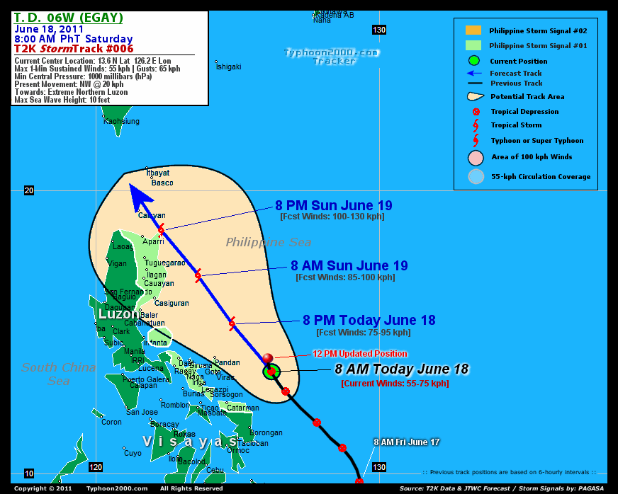
T2K TrackMap (for Public): 12:00 PM PhT Sat June 18
FORECAST OUTLOOK ANALYSIS (up to 2 days)* 06W's CLOSEST POINT OF APPROACH (CPA)* EXTENDED FORECAST TRACK (3 to 5 days)* EFFECTS & HAZARDS SUMMARY TROPICAL CYCLONE WATCH CURRENT SW MONSOON INTENSITY: STRONG >> Mostly cloudy with widespread moderate to heavy rains w/ squalls & thunderstorms can be expected along the following affected areas: SULU SEA, WESTERN VISAYAS, MINDORO, & WESTERN MINDANAO. Light to moderate SW'ly winds (not in excess of 40 kph) will blow. Important Note: Please keep in mind that the above forecast outlook, extended forecast, effects-hazards, current monsoon intensity, & tropical cyclone watch changes every 6 to 12 hrs! PHILIPPINE STORM WARNING SIGNAL # ONE (1) The above areas will have rains and winds of not more than 60 kph today. Coastal waters will be moderate to rough.
06W (EGAY) is expected to intensify, becoming a tropical storm later tonight...maintaining a NW to NNW track within the next 48 hours, passing very close to the NE tip of Cagayan tomorrow evening.  THIS EVENING (SAT): Attaining Tropical Storm strength while passing to the north of Catanduanes Island...about 150 km NNE of Pandan, Catanduanes, PH [8PM JUN 18: 15.3N 124.8E @ 75kph]. TOMORROW MORNING (SUN): Passing well to the east of Aurora Province and intensifying further...about 115 km East of Palanan Bay, Isabela, PH [8AM JUN 19: 17.0N 123.6E @ 85kph]. TOMORROW EVENING (SUN): Now off the coast of Cagayan..about 75 km ENE of Aparri, Cagayan, PH [8PM JUN 19: 18.6N 122.3E @ 95kph]. MONDAY MORNING: Upgraded to a Severe Tropical Storm as it traverses the Balintang Channel...about 125 km WSW of Basco, Batanes, PH [8AM JUN 20: 19.9N 121.0E @ 100kph].
Maximum Sustained Winds (1-min. avg) are near 55 km/hr (30 knots) with higher gusts. 06W (EGAY) is a Tropical Depression (TD) on the Saffir-Simpson Tropical Cyclone Scale. NORTHERN CAGAYAN: about 15 km North of Escaparda Point [ETA: between 5:00 PM-11:00 PM Tomorrow]. TUESDAY MORNING: Weakening as it traverses the South China Sea...approaching the coast of Southeastern China [8AM JUNE 21: 21.7N 118.7E @ 95kph]. WEDNESDAY MORNING: Off the coast of Fujian-Eastern Guangdong, China...prepares to make landfall...continues losing strength [8AM JUNE 22: 23.1N 117.1E @ 75kph]. THURSDAY MORNING: Over Fujian Province...downgraded to a Tropical Depression (TD) after making landfall [8AM JUNE 23: 24.6N 116.1E @ 35kph].
*Please be reminded that the Forecast Outlook changes every 6 hours, and the Extended Forecast Track have an average error of 250 km on Day 3...450 km on Day 4...and 650 km on Day 5, while the wind speed forecast error, averages 35 kph per day. Therefore, a turn to the left or right of its future track and changes in its wind speed must be anticipated from time to time.
06W's (EGAY) circulation has started once again to become disorganized w/ most of its rain-cloud convection displaced West & NW of its low-level center. Below are the summary of the depression's parts and its hazards affecting specific areas: RAINBANDS - affecting & spreading across Bicol Region, Polillo Islands, Northern Quezon, Northern Samar Island, Masbate, and portions of Southern Quezon-Bondoc Peninsula. Tropical Depression Conditions w/ moderate to strong winds (30-61 kph) can be expected along these bands (click here to know more about Rainbands). 24HR TOTAL RAINFALL ACCUMULATION - from 5 up to 150 mm (low to medium rainfall) can be expected along the outer & inner rainbands...with isolated amounts of up to 350 mm (high) near the center of 06W (EGAY). (click to open NOAA's eTRaP graphic).
A new Tropical Disturbance 99W (LPA/1008 MB) was spotted slowly developing over the Caroline Islands, SW of Guam. Its possible center was located near lat 7.7N lon 142.8E...about 1785 km East of Mindanao, PH...with 1-min maximum sustained winds of 30 kph near the center...drifting WNW slowly. The 24-Hr. Tropical Cyclone Formation Potential on this system is @ 20% [Low]. View the latest satellite flash loop on this disturbance. ![]()
PAGASA Philippine Storm Warnings Signals

In Effect: CAMARINES SUR, CAMARINES NORTE, ALBAY, CATANDUANES, SORSOGON, POLILLO IS., AURORA, CAGAYAN, ISABELA & NORTHERN SAMAR.
Residents living in low-lying and mountainous areas under Public Storm Warning Signal Number 1 are alerted against flashfloods, mudslides and landslides.
JTWC (US NAVY & AIR FORCE) REMARKS:
REMARKS (for Meteorologists): 8 AM (00 GMT) SAT 18 JUNE POSITION: 13.6N 126.2E.
*TROPICAL DEPRESSION (TD) 06W (SIX), LOCATED APPROXIMATELY 305
NM EAST-SOUTHEAST OF MANILA, PHILIPPINES, HAS TRACKED NORTHWESTWARD
AT 11 KNOTS OVER THE PAST SIX HOURS. THE CURRENT POSITION IS BASED
ON RECENT MICROWAVE SATELLITE IMAGERY, INCLUDING A 172033Z TRMM
PASS, WHICH SHOWS A NEARLY FULLY EXPOSED LOW LEVEL CIRCULATION
CENTER (LLCC) WITH DEEP CONVECTION CONFINED TO THE WESTERN
PERIPHERY. THE CURRENT INTENSITY ESTIMATE OF 30 KNOTS IS CONSISTENT
WITH RECENT DVORAK T-NUMBER ESTIMATES FROM PGTW AND KNES OF 2.0 AND
2.5 RESPECTIVELY. TD 06W CONTINUES TO TRACK NORTHWESTWARD ALONG THE
SOUTHWESTERN PERIPHERY OF A SUBTROPICAL STEERING RIDGE TO THE
NORTHEAST...(more)
_______________________________________________________________________________________________________________________________________
RECENT TYPHOON2000.COM TRACKING CHART:
_________________________________________________________________________________________________________________
RECENT MULTI-AGENCY TROPICAL CYCLONE FORECAST TRACKING CHART:
**N/A**

> Image source: NOAA SATELLITE CENTER: http://www.ssd.noaa.gov/mtsat/flt/t1/rgb.jpg
> Image source: Wunderground.com Tropical Page (http://www.wunderground.com/tropical)
____________________________________________________________________________________________________________________
LATEST 24 HR. TOTAL RAINFALL AMOUNTS / ENSEMBLE TROPICAL RAINFALL POTENTIAL (eTRaP):

> Image source: NOAA Satellite & Information Service (http://www.ssd.noaa.gov/PS/TROP/etrap.html)
>> To know the meteorological terminologies and acronyms used on this update visit the ff:
http://typhoon2000.ph/tcterm.htm
http://www.nhc.noaa.gov/aboutgloss.shtml
http://www.srh.noaa.gov/oun/severewx/glossary.php
http://www.srh.weather.gov/fwd/glossarynation.html
http://www.nhc.noaa.gov/acronyms.shtml
__________________________________________________________________________________________
For the complete details on TD 06W (EGAY)...go visit our website @:
> http://www.typhoon2000.com
> http://www.maybagyo.com
Copyright © 2011 Typhoon2000.com All Rights Reserved

No comments:
Post a Comment