
for Saturday, 18 June 2011 [7:00 PM PhT]![]()

<<<Typhoon2000.com Mobile >>>
Get the latest 3-hrly SMS Storm Alerts on EGAY!
For more details: Text T2K HELP to
2800 (Globe/TM) | 216 (Smart/TNT) | 2288 (Sun)
*Only P2.50 (Smart/Globe) / P2.00 (Sun) per msg received.
Click here on how to use this service (in PDF file)
Powered by: Synermaxx Corporation
Typhoon2000 (T2K) NEWS (Saturday June 18 2011):
Currently issuing 3-hrly web, twitter and e-mail updates (except 12:00 Midnight) on TS 06W (EGAY).
06W (EGAY) MAX WIND SPEED PER AGENCY:
+ USA (JTWC/1-min avg): 65 km/hr
+ Japan (JMA/10-min avg): 55 km/hr
+ Philippines (PAGASA/10-min avg): 55 km/hr
TROPICAL STORM 06W [EGAY]
T2K PUBLIC ADVISORY NUMBER 007
6:00 PM PhT (10:00 GMT) Sat 18 June 2011
Sources: T2K Extrap Analysis/JTWC Warning #007/SatFixes
View: Advisory Archives (2004-2011)
Tropical Storm 06W (EGAY) heading towards Northeastern Luzon...away from Catanduanes...will intensify further. Enhanced Southwest Monsoon bringing rains along the western sections of Luzon and Visayas.
Residents and visitors along the Eastern Coast of Central & Northern Luzon should closely monitor the progress of 06W (EGAY).
Do not use this for life or death decision. This advisory is intended for additional information purposes only. Kindly refer to your country's official weather agency for local warnings, advisories & bulletins.
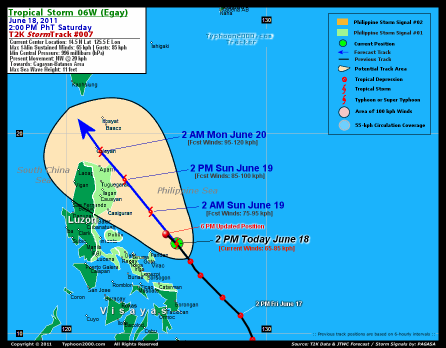
CURRENT STORM INFORMATION
Time/Date: 6:00 PM PhT Sat June 18 2011
Location of Center: 14.9º N Lat 125.0º E Lon
Distance 1: 125 km (67 nm) NNE of Pandan, Catanduanes
Distance 2: 180 km (97 nm) NNE of Virac, Catanduanes
Distance 3: 240 km (130 nm) NE of Metro Naga/CWC
Distance 4: 245 km (132 nm) ENE of Daet, CamNorte
Distance 5: 345 km (185 nm) SE of Casiguran, Aurora
Distance 6: 355 km (192 nm) East of Infanta, Quezon
Distance 7: 380 km (205 nm) ESE of Baler, Aurora
Distance 8: 430 km (232 nm) ENE of Metro Manila
MaxWinds (1-min avg): 65 kph (35 kts) near the center
Peak Wind Gusts: 85 kph (45 kts)
Present Movement: NW @ 20 kph (11 kts)
Towards: Cagayan-Batanes Area
CPA [ETA] to Cagayan: Tomorrow Evening [5PM-11PM PhT]
24hr Rainfall Accum (near center): 350 mm (High)
Rainrate (near center): 20-25 mm/hr (Mod)
Minimum Central Pressure: 996 millibars (hPa)
Saffir-Simpson Typhoon Scale: TS
Size (in Diameter): --- km (--- nm) / N/A
Wind Area Distribution (in Knots): Current Wind Profile
Max Sea Wave Height (near center): 11 ft (3.3 m)
Possible Storm Surge Height: 0 ft [0 m]
T2K TrackMap (for Public): 6:00 PM PhT Sat June 18
FORECAST OUTLOOK ANALYSIS (up to 2 days)* 06W's CLOSEST POINT OF APPROACH (CPA)* EXTENDED FORECAST TRACK (3 to 5 days)* EFFECTS & HAZARDS SUMMARY TROPICAL CYCLONE WATCH CURRENT SW MONSOON INTENSITY: STRONG >> Mostly cloudy with widespread moderate to heavy on-&-off rains w/ squalls & thunderstorms will be expected along the following affected areas: SULU SEA, VISAYAS, PALAWAN, CALAMIAN GROUP, METRO MANILA, SOUTHERN TAGALOG PROVINCES, MINDORO, & WESTERN MINDANAO. Light to moderate SW'ly winds (not in excess of 40 kph) will blow. Important Note: Please keep in mind that the above forecast outlook, extended forecast, effects-hazards, current monsoon intensity, & tropical cyclone watch changes every 6 to 12 hrs! PHILIPPINE STORM WARNING SIGNAL # ONE (1) The above areas will have rains and winds of not more than 60 kph tonight. Coastal waters will be moderate to rough.
06W (EGAY) is expected to intensify further as it continues moving NNW to NW track within the next 48 hours, passing along the NE tip of Cagayan tomorrow evening.  TOMORROW EARLY MORNING (SUN): Intensifying as it nears the NE Coast of Luzon...about 225 km East of Casiguran, Aurora, PH [2AM JUN 19: 16.1N 124.2E @ 75kph]. TOMORROW AFTERNOON (SUN): Just along the coast of Isabela-Cagayan...still intensifying...about 130 km East of Tuguegaro City, Cagayan, PH [2PM JUN 19: 17.7N 122.9E @ 85kph]. MONDAY EARLY MORNING: Enters the Balintang Channel after passing the NE tip of Cagayan...strengthens to a Severe Tropical Storm...about 30 km SE of Calayan Island, Cagayan, PH [2AM JUN 20: 19.1N 121.7E @ 95kph]. MONDAY AFTERNOON: Moving just west of Bashi Channel or off the South China Sea, attains peak intensity...about 190 km West of Basco, Batanes, PH [2PM JUN 20: 20.4N 120.2E @ 100kph].
Maximum Sustained Winds (1-min. avg) are near 65 km/hr (35 knots) with higher gusts. 06W (EGAY) is a Tropical Storm (TS) on the Saffir-Simpson Tropical Cyclone Scale. NORTHERN CAGAYAN: Over Escaparda Point [ETA: between 7:00 PM-8:00 PM Tomorrow]. TUESDAY AFTERNOON: Approaching the coast of Southeastern China...starts losing strength [2PM JUNE 21: 22.4N 117.6E @ 95kph]. WEDNESDAY AFTERNOON: Makes landfall along the Fujian-Eastern Guangdong, China...rapidly losing strength [2PM JUNE 22: 23.7N 116.5E @ 75kph]. THURSDAY AFTERNOON: Just an area of low pressure, dissipating over Fujian Province [2PM JUNE 23: 25.1N 116.3E @ 35kph].
*Please be reminded that the Forecast Outlook changes every 6 hours, and the Extended Forecast Track have an average error of 250 km on Day 3...450 km on Day 4...and 650 km on Day 5, while the wind speed forecast error, averages 35 kph per day. Therefore, a turn to the left or right of its future track and changes in its wind speed must be anticipated from time to time.
06W's (EGAY) circulation slightly improved but still the low-level circulation center (LLCC) is not aligned with the rain-cloud convection. Below are the summary of the depression's parts and its hazards affecting specific areas: RAINBANDS - affecting & spreading across Aurora, Quezon, Bicol Region, Polillo Islands, Northern Samar, and portions of Southern Tagalog Provinces. Tropical Depression Conditions w/ moderate to strong winds (30-61 kph) can be expected along these bands (click here to know more about Rainbands). 24HR TOTAL RAINFALL ACCUMULATION - from 5 up to 150 mm (low to medium rainfall) can be expected along the outer & inner rainbands...with isolated amounts of up to 350 mm (high) near the center of 06W (EGAY). (click to open NOAA's eTRaP graphic).
The new Tropical Disturbance 99W (LPA/1008 MB) continues to develop over the Caroline Islands, SW of Guam. Its possible center was located near lat 7.0N lon 142.4E...about 1745 km East of Mindanao, PH...with 1-min maximum sustained winds of 30 kph near the center...drifting SW slowly & consolidating. The 24-Hr. Tropical Cyclone Formation Potential on this system remains @ 20% [Low]. View the latest satellite flash loop on this disturbance. ![]()
PAGASA Philippine Storm Warnings Signals

In Effect: CAMARINES SUR, CAMARINES NORTE, ALBAY, CATANDUANES, SORSOGON, POLILLO IS., QUEZON, AURORA, CAGAYAN, ISABELA & NORTHERN SAMAR.
Residents living in low-lying and mountainous areas under Public Storm Warning Signal Number 1 are alerted against flashfloods, mudslides and landslides.
JTWC (US NAVY & AIR FORCE) REMARKS:
REMARKS (for Meteorologists): 2 PM (06 GMT) SAT 18 JUNE POSITION: 14.5N 125.5E.
*TROPICAL STORM (TS) 06W, LOCATED APPROXIMATELY 260 NM EAST OF
MANILA, PHILIPPINES, HAS TRACKED NORTHWEST AT 11 KNOTS DURING THE
PAST SIX HOURS. ANIMATED MULTISPECTRAL SATELLITE IMAGERY (MSI) SHOWS
SLIGHT IMPROVEMENT IN ORGANIZATION DURING THE PAST 8 HOURS, BUT THE
LOW LEVEL CIRCULATION CENTER (LLCC) REMAINS PARTIALLY EXPOSED DUE TO
EASTERLY WIND SHEAR. ALTHOUGH A 180117Z METOPA MICROWAVE IMAGE
SHOWED LITTLE DEEP CONVECTION, RECENT MSI POINTS TO DEEPENING
CONVECTION OVER THE SOUTHERN FLANK. THE 180000Z PGTW STREAMLINE
ANALYSIS AND SURFACE REPORTS FROM EASTERN LUZON AND SAMAR REVEAL A
WEAK SOUTHWESTERLY FLOW EXTENDING ACROSS THE VISAYAS, AND A WELL
ESTABLISHED AND VIGOROUS SOUTHERLY WIND FIELD OVER THE PHILIPPINE
SEA. THE UPPER LEVEL STREAMLINE ANALYSIS REVEALS AN ANTICYCLONE 300
NM TO THE NORTHWEST OF THE LLCC. ANIMATED WATER VAPOR IMAGERY SHOWS
OUTFLOW IS BEING SUPPRESSED OVER THE POLEWARD SEMICIRCLE DUE TO AN
EXTENSIVE TUTT ALONG THE 20TH LATITUDE. EQUATORWARD OUTFLOW,
HOWEVER, IS WELL DEVELOPED. CURRENTLY, TS 06W EXISTS IN A REGION OF
FAVORABLE UPPER LEVEL DIFFLUENCE AND 30-31 DEGREE WATERS. THE
CURRENT INTENSITY IS BASED ON A COMBINATION OF SUBJECTIVE DVORAK
ESTIMATES FROM PGTW, RJTD, AND KNES AND SHIP REPORTS TO THE SOUTH
AND EAST OF THE LLCC. VERTICAL WIND SHEAR (VWS) IS ESTIMATED AT 15-
20 KNOTS, BUT THE SYSTEM IS TRACKING TOWARD A REGION OF DECREASING
VWS OFF THE EAST COAST OF LUZON. THE COMBINATION OF DECREASING VWS,
WARM WATERS, AND SUSTAINED EQUATORWARD OUTFLOW WILL ALLOW TS 06W TO
INTENSIFY UNTIL IT TRACKS NORTH OF LUZON. ONCE NORTH OF LUZON,
INCREASING VWS AND FALLING OCEAN HEAT CONTENT WILL COUPLE TO WEAKEN
THE SYSTEM. MODEL GUIDANCE IS IN GOOD AGREEMENT AS FAR AS TRACKING
TS 06W INTO THE LUZON STRAIT. AFTER TAU 60, MODEL DISPARITY
INCREASES BUT ALL GUIDANCE SHOWS A NORTHWESTWARD TRACK WITH LANDFALL
SOMEWHERE BETWEEN HONG KONG AND CENTRAL TAIWAN. THE CURRENT TRACK
FORECAST FOLLOWS CONSENSUS. INTENSITY GUIDANCE IS ALSO IN REASONABLE
AGREEMENT. THE CURRENT INTENSITY FORECAST IS WEIGHTED TOWARDS STIPS
11 GUIDANCE...(more)
_______________________________________________________________________________________________________________________________________
RECENT TYPHOON2000.COM TRACKING CHART:
_________________________________________________________________________________________________________________
RECENT MULTI-AGENCY TROPICAL CYCLONE FORECAST TRACKING CHART:
**N/A**

> Image source: NOAA SATELLITE CENTER: http://www.ssd.noaa.gov/mtsat/flt/t1/rgb.jpg
> Image source: Wunderground.com Tropical Page (http://www.wunderground.com/tropical)
____________________________________________________________________________________________________________________
LATEST 24 HR. TOTAL RAINFALL AMOUNTS / ENSEMBLE TROPICAL RAINFALL POTENTIAL (eTRaP):

> Image source: NOAA Satellite & Information Service (http://www.ssd.noaa.gov/PS/TROP/etrap.html)
>> To know the meteorological terminologies and acronyms used on this update visit the ff:
http://typhoon2000.ph/tcterm.htm
http://www.nhc.noaa.gov/aboutgloss.shtml
http://www.srh.noaa.gov/oun/severewx/glossary.php
http://www.srh.weather.gov/fwd/glossarynation.html
http://www.nhc.noaa.gov/acronyms.shtml
__________________________________________________________________________________________
For the complete details on TD 06W (EGAY)...go visit our website @:
> http://www.typhoon2000.com
> http://www.maybagyo.com
Copyright © 2011 Typhoon2000.com All Rights Reserved

No comments:
Post a Comment