
for Thursday, 28 July 2011 [7:06 AM PhT]![]()

<<<Typhoon2000.com Mobile >>>
Get the latest 6-hrly SMS Storm Alerts on JUANING!
For more details: Text T2K TYPHOON to
2800 (Globe/TM) | 216 (Smart/TNT) | 2288 (Sun)
*Only P2.50 (Smart/Globe) / P2.00 (Sun) per msg received.
Click here on how to use this service (in PDF file)
Powered by: Synermaxx Corporation
Typhoon2000 (T2K) NEWS (Thursday July 28 2011):
Resuming the 6-hrly web, twitter and e-mail updates (except 12:00 Midnight & 3:00 AM) on NOCK-TEN (JUANING).
NOCK-TEN (JUANING) MAX WIND SPEED PER AGENCY:
+ USA (JTWC/1-min avg): 95 km/hr
+ Japan (JMA/10-min avg): 95 km/hr
+ Philippines (PAGASA/10-min avg): 95 km/hr
+ Korea (KMA/10-min avg): 95 km/hr
+ Taiwan (CWB/10-min avg): 85 km/hr
+ Beijing (NMC/2-min avg): 85 km/hr
+ Hong Kong (HKO/10-min avg): 105 km/hr
:: Click here to see Multi-Agency Forecast Tracks
TROPICAL STORM NOCK-TEN [JUANING/10W/1108]
T2K PUBLIC ADVISORY NUMBER 011
6:00 AM PhT (22:00 GMT) Thu 28 July 2011
Source: T2K Extrap Analysis/JTWC Warning #013/SatFixes
View: Advisory Archives (2004-2011)
Tropical Storm NOCK-TEN (JUANING) moving faster WNW across the West Philippine Sea...will move out of the Philippine Area of Responsibility (PAR) later today. Its outer rainbands still affecting La Union, Ilocos Provinces, Zambales & Pangasinan. Meanwhile, the Tropical Depression (11W) over the Caroline Islands is still outside of the PAR and was moving NW...not yet a threat to the Philippines.
Residents and visitors along Southern China particularly Hainan Island should closely monitor the progress of NOCK-TEN (JUANING).
Do not use this for life or death decision. This advisory is intended for additional information purposes only. Kindly refer to your country's official weather agency for local warnings, advisories & bulletins.
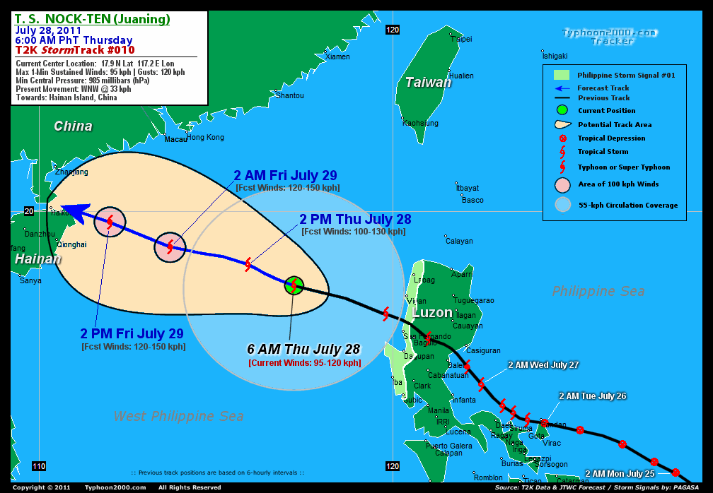
CURRENT STORM INFORMATION
Time/Date: 6:00 AM PhT Thu July 28 2011
Location of Center: 17.9º N Lat 117.2º E Lon
Distance 1: 340 km (185nm) WNW of Vigan City
Distance 2: 360 km (195 nm) WSW of Laoag City
Distance 3: 400 km (215 nm) NW of Baguio City
Distance 4: 555 km (300 nm) NW of Metro Manila
Distance 5: 570 km (308 nm) SE of Hong Kong
Distance 6: 610 km (330 nm) SE of Macau
Distance 7: 720 km (388 nm) ESE of Qionghai, Hainan
MaxWinds (1-min avg): 95 kph (50 kts) near the center
Peak Wind Gusts: 120 kph (65 kts)
Present Movement: WNW @ 33 kph (18 kts)
Towards: West Philippine Sea
24hr Rainfall Accum (near center): 310 mm (High)
Rainrate (near center): 10-20 mm/hr (Mod-Heavy)
Minimum Central Pressure: 985 millibars (hPa)
Saffir-Simpson Typhoon Scale: Tropical Storm
Size (in Diameter): 590 km (320 nm) / Average
Wind Area Distribution (in Knots): Current Wind Profile
Possible Storm Surge Height: 0-3 ft [0-0.9 m]
T2K TrackMap (for Public): 6:00 AM PhT Thu July 28
FORECAST OUTLOOK ANALYSIS (up to 2 days)* NOCK-TEN's (JUANING) CLOSEST POINT OF APPROACH (CPA)* EXTENDED FORECAST TRACK (3 to 5 days)* EFFECTS & HAZARDS SUMMARY TROPICAL CYCLONE WATCH CURRENT SW MONSOON INTENSITY: STRONG >> Cloudy skies with occasional showers, rains, squalls & thunderstorms will be expected along the following affected areas: PALAWAN, WESTERN VISAYAS & WESTERN LUZON. Moderate to strong SW'ly winds (not in excess of 45 kph) will blow. Important Note: Please keep in mind that the above forecast outlook, extended forecast, effects-hazards, current monsoon intensity, & tropical cyclone watch changes every 6 to 12 hrs! PHILIPPINE STORM WARNING SIGNAL # ONE (1) The above areas will have rains and winds of not more than 60 kph today. Coastal waters will be moderate to rough.
NOCK-TEN (JUANING) is expected to continue moving WNW and re-intensify through the next 1-2 days while moving along the West Philippine Sea (South China Sea). It shall again become a typhoon tomorrow before it reaches Hainan Island, China. Below is the summary of the 2-day forecast for this system.  THIS AFTERNOON (THU): Gaining strength while moving across the West Philippine Sea...exits the Philippine Area of Responsibility (PAR)...about 450 km SSE of Hong Kong, China [2PM JUL 28: 18.5N 115.9E @ 100kph]. TOMORROW EARLY MORNING (FRI): Regains Typhoon strength as it moves closer to Hainan Island...about 370 km SSW of Hong Kong [2AM JUL 29: 19.0N 113.7E @ 120kph]. TOMORROW AFTERNOON (FRI): Off the coast of NE Hainan...about 185 km ESE of Haikou, Hainan Island [2PM JUL 29: 19.7N 112.0E @ 120kph]. SATURDAY EARLY MORNING: Weakens into storm while passing over Haikou, Hainan...about 135 km South of Zhanjiang, China [2AM JUL 30: 20.1N 110.3E @ 110kph].
Maximum Sustained Winds (1-min. avg) are near 95 km/hr (50 knots) with higher gusts. NOCK-TEN (JUANING) is a Tropical Storm (TS) on the Saffir-Simpson Tropical Cyclone Scale. Tropical Storm Force Winds (62-117 km/hr) extend outward up to 150 kilometers (80 nautical miles) from the center. NOCK-TEN is an average-sized tropical cyclone with a diameter of 590 kilometers (320 nautical miles) across. HAINAN ISLAND, CHINA: Along the Northern Coast...About 65 km ESE of Haikou, Hainan Island [ETA: between 12:00-3:00 AM PhT Saturday, July 30]. SUNDAY EARLY MORNING: Downgraded into a Tropical Storm while moving across the Gulf of Tonkin...makes landfall over Northern Vietnam [2AM JUL 31: 19.7N 106.5E @ 100kph]. MONDAY EARLY MORNING: Downgraded into a TD as it rapidly dissipates while over Laos [2AM AUG 01: 20.0N 103.3E @ 45kph]. TUESDAY EARLY MORNING: Dissipated along the Thailand-Laos-Chinese Border [2AM AUG 02: 21.5N 101.1E @ 35kph].
*Please be reminded that the Forecast Outlook changes every 6 hours, and the Extended Forecast Track have an average error of 250 km on Day 3...450 km on Day 4...and 650 km on Day 5, while the wind speed forecast error, averages 35 kph per day. Therefore, a turn to the left or right of its future track and changes in its wind speed must be anticipated from time to time.
NOCK-TEN's (JUANING) circulation has re-intensified as it moves faster across the Western Philippine Sea (South China Sea). Its rainbands has moved back to the open sea. Below is the summary of the storm's parts and its hazards affecting specific areas: INNER RAINBANDS - now over wateer...no longer affecting any land areas. Tropical Storm Conditions w/ Tropical Storm Force Winds (62-117 kph) will be expected along these bands. OUTER RAINBANDS - spreading & affecting Western Luzon including the islands of Batanes-Calayan-Babuyan.. Tropical Depression Conditions w/ moderate to strong winds (25-61 kph) will be expected along these bands (click here to know more about Rainbands). 24HR TOTAL RAINFALL ACCUMULATION - from 5 up to 150 mm (low to high rainfall) can be expected along the outer & inner rainbands...with isolated amounts of up to 310 mm (high) near the center of MA-ON (INENG). (click to open NOAA's eTRaP graphic).
Tropical Depression 11W (UNNAMED) accelerating NW-ward across the Caroline Islands...may become a Tropical Storm soon. Its center was located near lat 12.8N lon 138.0E...about 1485 km East of Bicol Region...with 1-min maximum sustained winds of 55 kph near the center. View the latest satellite flash loop on this cyclone. ![]()
PAGASA Philippine Storm Warnings Signals 
In Effect: ILOCOS NORTE, ILOCOS SUR, ABRA, LA UNION, PANGASINAN, & ZAMBALES.
Residents living in low-lying and mountainous areas under Public Storm Warning Signal Number 1 are alerted against flashfloods, mudslides and landslides.
JTWC (US NAVY & AIR FORCE) REMARKS:
REMARKS (for Meteorologists): 2 AM (18 GMT) THU 28 JULY POSITION: 18.1N 118.3E.
*TROPICAL STORM 10W (NOCK-TEN), LOCATED APPROXIMATELY 250 NM NORTH-
NORTHWEST OF MANILA, PHILIPPINES, HAS TRACKED WEST-NORTHWESTWARD AT
17 KNOTS OVER THE PAST SIX HOURS. ANIMATED INFRARED SATELLITE
IMAGERY SHOWS A REDEVELOPING LOW LEVEL CIRCULATION CENTER (LLCC)
WITH A PROMINENT BANDING FEATURE TO THE SOUTH. A 271616Z 37H TRMM
IMAGE DEPICTS TIGHTLY CURVED LOW LEVEL BANDING WRAPPING AROUND THE
MAJORITY OF THE LLCC, WHICH EXTENDS FROM THE BANDING FEATURE TO THE
SOUTH. A 271808Z 89H AMSU IMAGE REVEALS THAT DEEP CONVECTION IS
CONTAINED WITHIN THE BANDING FEATURE AS WELL AS A CONVECTIVE COMPLEX
THAT LIES JUST OFF THE COAST OF WESTERN LUZON. HOWEVER, THERE IS A
LACK OF CENTRAL DEEP CONVECTION. UPPER LEVEL ANALYSIS SHOWS TS 10W
TO BE IN A FAVORABLE DIVERGENT ENVIRONMENT WITH EXCELLENT
EQUATORWARD OUTFLOW AND A POLEWARD OUTFLOW CHANNEL INTO A TROPICAL
UPPER TROPOSPHERIC TROUGH THAT LIES TO THE NORTHEAST. TS 10W WILL
CONTINUE TO TRACK ALONG THE SOUTHERN PERIPHERY OF A STRONG
SUBTROPICAL RIDGE CENTERED OFF THE COAST OF TOKYO, JAPAN IN A
STRAIGHT-RUNNER WESTWARD TRACK. THE CURRENT POSITION IS BASED ON THE
AFOREMENTIONED MICROWAVE IMAGES AND ANIMATED INFRARED IMAGERY WITH
FAIR CONFIDENCE AND INITIAL INTENSITY IS IN LINE WITH THE NUMERICAL
GUIDANCE...(more info)
>> NOCK-TEN, meaning: Bird. Name contributed by: Laos.
_______________________________________________________________________________________________________________________________________
RECENT TYPHOON2000.COM (JTWC) TRACKING CHART:
_________________________________________________________________________________________________________________
RECENT MULTI-AGENCY TROPICAL CYCLONE FORECAST TRACKING CHART: 
_________________________________________________________________________________________________________________

> Image source: NOAA SATELLITE CENTER: http://www.ssd.noaa.gov/mtsat/flt/t1/rgb.jpg
> Image source: Wunderground.com Tropical Page (http://www.wunderground.com/tropical)
____________________________________________________________________________________________________________________
LATEST 24HR. TOTAL RAINFALL AMOUNTS / ENSEMBLE TROPICAL RAINFALL POTENTIAL (eTRaP):

> Image source: NOAA Satellite & Information Service (http://www.ssd.noaa.gov/PS/TROP/etrap.html)
>> To know the meteorological terminologies and acronyms used on this update visit the ff:
http://typhoon2000.ph/tcterm.htm
http://www.nhc.noaa.gov/aboutgloss.shtml
http://www.srh.noaa.gov/oun/severewx/glossary.php
http://www.srh.weather.gov/fwd/glossarynation.html
http://www.nhc.noaa.gov/acronyms.shtml
__________________________________________________________________________________________
For the complete details on TS NOCK-TEN (JUANING)...go visit our website @:
> http://www.typhoon2000.com
> http://www.maybagyo.com
Copyright © 2011 Typhoon2000.com All Rights Reserved

No comments:
Post a Comment