
for Wednesday, 27 July 2011 [12:45 PM PhT]

<<<Typhoon2000.com Mobile >>>
Get the latest 3-hrly SMS Storm Alerts on JUANING!
For more details: Text T2K TYPHOON to
2800 (Globe/TM) | 216 (Smart/TNT) | 2288 (Sun)
*Only P2.50 (Smart/Globe) / P2.00 (Sun) per msg received.
Click here on how to use this service (in PDF file)
Powered by: Synermaxx Corporation
Typhoon2000 (T2K) NEWS (Tuesday July 26 2011):
Currently issuing 3-hrly web, twitter and e-mail updates (except 12:00 Midnight & 3:00 AM) on NOCK-TEN (JUANING).
NOCK-TEN (JUANING) MAX WIND SPEED PER AGENCY:
+ USA (JTWC/1-min avg): 120 km/hr
+ Japan (JMA/10-min avg): 95 km/hr
+ Philippines (PAGASA/10-min avg): 95 km/hr
+ Korea (KMA/10-min avg): 95 km/hr
+ Taiwan (CWB/10-min avg): 95 km/hr
+ Beijing (NMC/2-min avg): 100 km/hr
+ Hong Kong (HKO/10-min avg): 95 km/hr
:: Click here to see Multi-Agency Forecast Tracks
TYPHOON NOCK-TEN [JUANING/10W/1108]
T2K PUBLIC ADVISORY NUMBER 009
12:00 PM PhT (04:00 GMT) Wed 27 July 2011
Source: T2K Extrap Analysis/JTWC Warning #010/SatFixes
View: Advisory Archives (2004-2011)
The cloud-filled eye of Typhoon NOCK-TEN (JUANING) is now traversing the northern part of Quirino...will move across Nueva Vizcaya-Ifugao-Benguet in the next few hours. Tropical Storm to Typhoon Conditions prevailing across Aurora, Quirino, Southern Isabela, Nueva Vizcaya, Ifugao & Benguet.
Residents and visitors along Luzon should closely monitor the progress of NOCK-TEN (JUANING).
Do not use this for life or death decision. This advisory is intended for additional information purposes only. Kindly refer to your country's official weather agency for local warnings, advisories & bulletins.
CURRENT STORM INFORMATION
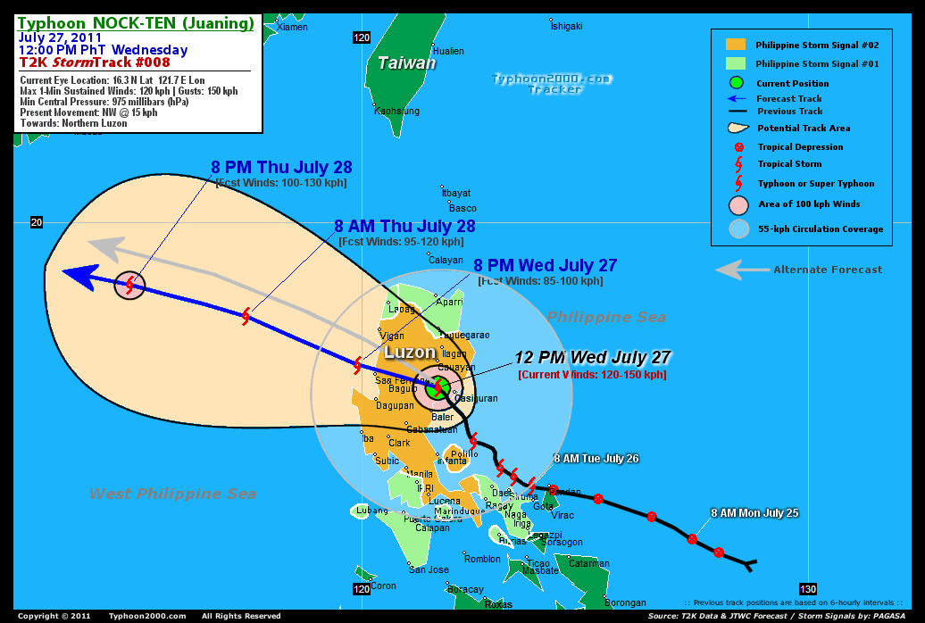
Time/Date: 12:00 PM PhT Wed July 27 2011
Location of Cloud-Filled Eye: 16.3º N Lat 121.7º E Lon
Distance 1: 45 km (25 nm) West of Casiguran, Aurora
Distance 2: 55 km (30 nm) North of Baler, Aurora
Distance 3: 65 km (35 nm) South of Cauayan, Isabela
Distance 4: 115 km (63 nm) NNE of Cabanatuan City
Distance 5: 165 km (90 nm) North of Infanta, Quezon
Distance 6: 100 km (55 nm) South of Ilagan City
Distance 7: 120 km (65 nm) East of Baguio City
Distance 8: 205 km (110 nm) NNE of Metro Manila
Distance 9: 145 km (78 nm) South of Tuguegarao City
Distance 10: 200 km (108 nm) SSE of Vigan City
Distance 11: 240 km (130 nm) SSE of Laoag City
MaxWinds (1-min avg): 120 kph (65 kts) near the center
Peak Wind Gusts: 150 kph (80 kts)
Present Movement: NW @ 15 kph (08 kts)
Towards: Northern Luzon
CPA [ETA] to Baguio: Wed Afternoon [4-5PM PhT]
24hr Rainfall Accum (near center): 200 mm (High)
Rainrate (near center): 15-25 mm/hr (Mod-Heavy)
Minimum Central Pressure: 975 millibars (hPa)
Saffir-Simpson Typhoon Scale: Tropical Storm
Size (in Diameter): 590 km (320 nm) / Average
Wind Area Distribution (in Knots): Current Wind Profile
Possible Storm Surge Height: 0-3 ft [0-0.9 m]
T2K TrackMap (for Public): 12:00 PM PhT Wed July 27
FORECAST OUTLOOK ANALYSIS (up to 2 days)* NOCK-TEN's (JUANING) CLOSEST POINT OF APPROACH (CPA)* EXTENDED FORECAST TRACK (3 to 5 days)* EFFECTS & HAZARDS SUMMARY TROPICAL CYCLONE WATCH CURRENT SW MONSOON INTENSITY: STRONG >> Cloudy skies with occasional showers, rains, squalls & thunderstorms will be expected along the following affected areas: PALAWAN & THE REST OF VISAYAS. Light to moderate SW'ly winds (not in excess of 60 kph) will blow. Important Note: Please keep in mind that the above forecast outlook, extended forecast, effects-hazards, current monsoon intensity, & tropical cyclone watch changes every 6 to 12 hrs! PHILIPPINE STORM WARNING SIGNAL # TWO (2) The above areas will experience stormy weather - where winds of 60-100 kph can be expected today. Coastal waters will be rough to very rough and extremely dangerous to all types of seacrafts. PHILIPPINE STORM WARNING SIGNAL # ONE (1) The above areas will have rains and winds of not more than 60 kph today. Coastal waters will be moderate to rough.
NOCK-TEN (JUANING) is expected to continue moving WNW to NW-ward across Northern Luzon & into the West Philippine Sea (South China Sea) within the next 1-2 days. It shall weaken slightly upon traversing the northern part of Central Luzon and re-intensify upon emerging over the West Philippine Sea. Below is the summary of the 2-day forecast for this system.  THIS EVENING (WED): Weakened into a Tropical Storm (TS) as it exits Northern Luzon while over the West Philippine Sea (South China Sea)...about 50 km WNW of San Fernando City, La Union [8PM JUL 27: 16.8N 119.9E @ 85kph]. TOMORROW MORNING (THU): Regain strength as it accelerates across the West Philippine Sea, farther away from Luzon...about 340 km WSW of Laoag City, Ilocos Norte [8AM JUL 28: 17.9N 117.4E @ 95kph]. TOMORROW EVENING (THU): Exits the Philippine Area of Responsibility (PAR) as it accelerates further WNW across the South China Sea...about 615 km WNW of Laoag City, Ilocos Norte [8PM JUL 28: 18.6N 114.8E @ 100kph]. FRIDAY MORNING: Almost a typhoon as it continued moving WNW across the South China Sea...approaching the NE Coast of Hainan Island, China...about 285 km East of Hainan Island, China [8AM JUL 29: 19.3N 112.4E @ 110kph].
Maximum Sustained Winds (1-min. avg) are near 120 km/hr (55 knots) with higher gusts. NOCK-TEN (JUANING) is a Category 1 Typhoon on the Saffir-Simpson Tropical Cyclone Scale. Tropical Storm Force Winds (62-117 km/hr) extend outward up to 240 kilometers (130 nautical miles) from the center. NOCK-TEN is an average-sized tropical cyclone with a diameter of 590 kilometers (320 nautical miles) across. BENGUET: Over Northern Benguet...about 30 km NNE of Baguio City [ETA: between 4:00-5:00 PM PhT Today]. LA UNION-ILOCOS SUR: Along the La Union-Ilocos Sur Border...About 30 km NNE of San Fernando City [ETA: between 5:00-6:00 PM PhT Today]. SATURDAY MORNING: Off the West Coast of Hainan Island, China...moving into the Gulf of Tonkin - after crossing the northern part of Hainan [8AM JUL 30: 19.9N 108.8E @ 100kph]. SUNDAY MORNING: Makes landfall over Northern Vietnam...rapidly dissipating [8AM JUL 31: 19.9N 105.8E @ 95kph]. MONDAY MORNING: Dissipating over land...in the vicinity of Laos [8AM AUG 01: 19.7N 102.7E @ 35kph].
*Please be reminded that the Forecast Outlook changes every 6 hours, and the Extended Forecast Track have an average error of 250 km on Day 3...450 km on Day 4...and 650 km on Day 5, while the wind speed forecast error, averages 35 kph per day. Therefore, a turn to the left or right of its future track and changes in its wind speed must be anticipated from time to time.
NOCK-TEN's (JUANING) circulation has rapidly intensified producing a ragged Eye & a developed Eyewall prior in making landfall over Aurora Province. Its rainbands continues to spread across Luzon including Bicol Region. Below is the summary of the storm's parts and its hazards affecting specific areas: DECAYING CLOUD-FILLED EYE - now inland along over Central Aurora. Possible calm and lull conditions (with <20 kph winds) can be expected inside the eye (click here to know more about the EYE). DECAYING EYEWALL - inland...affecting Aurora & Southern Isabela Typhoon Conditions with Typhoon Force Winds (>118 kph) can be expected within this wall (click here to know more about the Eyewall). INNER RAINBANDS - spreading & affecting Rest of Quezon, Polillo Islands, Quirino, Nueva Vizcaya, Nueva Ecija, Benguet, Mountain Province, Ifugao, & La Union. Tropical Storm Conditions w/ Tropical Storm Force Winds (62-117 kph) will be expected along these bands. OUTER RAINBANDS - spreading & affecting Rest of Luzon including Bicol Region & the islands of Batanes-Calayan-Babuyan. Tropical Depression Conditions w/ moderate to strong winds (25-61 kph) will be expected along these bands (click here to know more about Rainbands). 24HR TOTAL RAINFALL ACCUMULATION - from 5 up to 100 mm (low to high rainfall) can be expected along the outer & inner rainbands...with isolated amounts of up to 200 mm (high) near the center of MA-ON (INENG). (click to open NOAA's eTRaP graphic).
Tropical Depression 11W (UNNAMED) moving NW-ward across the Caroline Islands...may become a Tropical Storm tomorrow. Its center was located near lat 10.2N lon 141.4E...about 370 km ENE of Yap, FSM...with 1-min maximum sustained winds of 55 kph near the center. View the latest satellite flash loop on this cyclone. ![]()
PAGASA Philippine Storm Warnings Signals 
In Effect: METRO MANILA, QUEZON, POLILLO ISLAND, RIZAL, BULACAN, PAMPANGA, BATAAN, ZAMBALES, TARLAC, PANGASINAN, NUEVA ECIJA, AURORA, QUIRINO, NUEVA VIZCAYA, BENGUET, IFUGAO, ISABELA, MT. PROVINCE, ILOCOS SUR, KALINGA, ABRA & LA UNION.
In Effect: THE REST OF LUZON, CAMARINES SUR, CAMARINES NORTE, ALBAY, MINDORO, LUBANG ISLAND, & BURIAS ISLAND.
Residents living in low-lying and mountainous areas under Public Storm Warning Signal Number 1 are alerted against flashfloods, mudslides and landslides.
REMARKS (for Meteorologists): 8 AM (00 GMT) WED 27 JULY POSITION: 15.6N 122.1E.
*TYPHOON 10W (NOCK-TEN), LOCATED APPROXIMATELY 90 NM NORTHEAST OF
MANILA, PHILIPPINES, HAS TRACKED NORTHWESTWARD AT 06 KNOTS OVER THE
PAST SIX HOURS. THE SYSTEM HAS RAPIDLY INTENSIFIED OVER THE PAST 24
HOURS (35 TO 65 KNOTS) AND HAS DEVELOPED A SMALL, RAGGED EYE.
UPGRADED TO TYPHOON INTENSITY BASED ON THE EYE AND DVORAK ESTIMATES
OF 65 KNOTS FROM PGTW...(more info)
>> NOCK-TEN, meaning: Bird. Name contributed by: Laos.
_______________________________________________________________________________________________________________________________________
RECENT TYPHOON2000.COM (JTWC) TRACKING CHART:
_________________________________________________________________________________________________________________
RECENT MULTI-AGENCY TROPICAL CYCLONE FORECAST TRACKING CHART: 

> Image source: NOAA SATELLITE CENTER: http://www.ssd.noaa.gov/mtsat/flt/t1/rgb.jpg
> Image source: Wunderground.com Tropical Page (http://www.wunderground.com/tropical)
____________________________________________________________________________________________________________________
LATEST 24HR. TOTAL RAINFALL AMOUNTS / ENSEMBLE TROPICAL RAINFALL POTENTIAL (eTRaP):

> Image source: NOAA Satellite & Information Service (http://www.ssd.noaa.gov/PS/TROP/etrap.html)
>> To know the meteorological terminologies and acronyms used on this update visit the ff:
http://typhoon2000.ph/tcterm.htm
http://www.nhc.noaa.gov/aboutgloss.shtml
http://www.srh.noaa.gov/oun/severewx/glossary.php
http://www.srh.weather.gov/fwd/glossarynation.html
http://www.nhc.noaa.gov/acronyms.shtml
__________________________________________________________________________________________
For the complete details on TY NOCK-TEN (JUANING)...go visit our website @:
> http://www.typhoon2000.com
> http://www.maybagyo.com
Copyright © 2011 Typhoon2000.com All Rights Reserved

No comments:
Post a Comment