
for Saturday, 01 October 2011 [7:14 PM PhT]
![]()

<<<Typhoon2000.com Mobile >>>
Get the latest 6-hrly SMS Storm Alerts on QUIEL!
For more details: Text T2K TYPHOON to
2800 (Globe/TM) | 216 (Smart/TNT) | 2288 (Sun)
*Only P2.50 (Smart/Globe) / P2.00 (Sun) per msg received.
Click here on how to use this service (in PDF file)
Powered by: Synermaxx Corporation
Typhoon2000 (T2K) NEWS (Saturday Oct 01 2011):
T2K ends the hourly/3-hrly updates...resumes 6-hrly web, email, & android (iTyphoon) updates (except 12:00 Midnight) on NALGAE (QUIEL).
 NALGAE's HRLY POSITION ESTIMATE: Click Here To View
 NALGAE (QUIEL) MAX WIND SPEED PER AGENCY:
+ USA (JTWC/1-min avg): 195 km/hr
+ Japan (JMA/10-min avg): 150 km/hr
+ Philippines (PAGASA/10-min avg): 150 km/hr
+ Beijing (NMC/2-min avg): 145 km/hr
+ Taiwan (CWB/10-min avg): 160 km/hr
+ Korea (KMA/10-min avg): 160 km/hr
+ Hong Kong (HKO/10-min avg): 160 km/hr
:: Click here to see Multi-Agency Forecast Tracks
TYPHOON NALGAE [QUIEL/22W/1119]
T2K PUBLIC ADVISORY NUMBER 010
6:00 PM PhT (10:00 GMT) Sat 01 October 2011
Source: T2K Analysis/JTWC TC Warning #017/SatFixes
View: Advisory Archives (2004-2011)
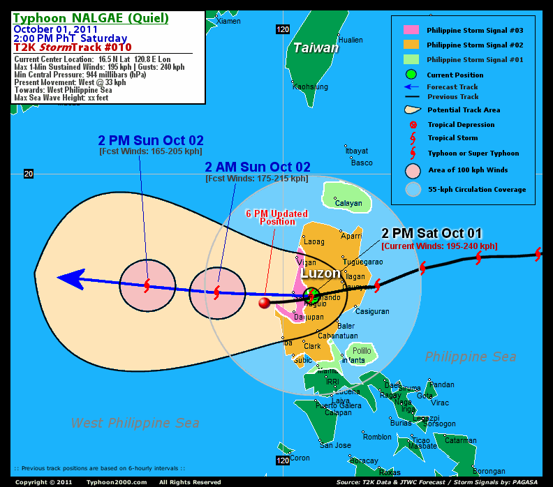
Typhoon NALGAE (QUIEL) now moving into the West Philippine Sea, after passing close to Cape Bolinao, Pangasinan. Typhoon Conditions will still occur across Pangasinan & La Union early this evening. Improving weather conditions expected after midnight.
Residents and visitors along Southern China should closely monitor the progress of NALGAE (QUIEL).
Do not use this for life or death decision. This advisory is intended for additional information purposes only. Kindly refer to your country's official weather agency for local warnings, advisories & bulletins.
CURRENT STORM INFORMATION
Time/Date: 6:00 PM PhT Sat October 01 2011
Location of Center: 16.3º N Lat 119.5º E Lon
Distance 1: 32 km West of Cape Bolinao
Distance 2: 92 km WNW of Dagupan City
Distance 3: 92 km WSW of San Fernando City
Distance 4: 118 km WSW of Baguio City
Distance 5: 123 km NNW of Iba, Zambales
Distance 6: 173 km SSW of Vigan City
Distance 7: 248 km NW of Metro Manila
MaxWinds (1-min avg): 165 kph (90 kts) near the center
Peak Wind Gusts: 205 kph (110 kts)
Present Movement: West @ 33 kph (18 kts)
Towards: West Philippine Sea
24hr Rainfall Accum (near center): 250 mm (High)
Rainrate (near center): 15-25 mm/hr (Mod-Heavy)
Minimum Central Pressure: 956 millibars (hPa)
Saffir-Simpson Typhoon Scale: Category 2
Size (in Diameter): 720 km (390 nm) [Large]
Wind Area Distribution (in Knots): Current Wind Profile
Max Sea Wave Height (near center): 28 ft
Possible Storm Surge Height: 6-8 ft [1.8-2.6 m]
T2K TrackMap (for Public): 6 PM PhT Sat Oct 01
3-DAY FORECAST OUTLOOK & ANALYSIS*
NALGAE (QUIEL) will continue moving westward (known in meteorology as a "Straight-Runner") throughout the forecast period...with a decrease in its forward speed. On the forecast track, the core of the typhoon will move out of the Philippine Area of Responsibility (PAR) Sunday...and will pass close to the South of Hainan Island on Monday.
Maximum Sustained Winds (1-min. avg) are near 165 km/hr (90 knots) with higher gusts. NALGAE is a Category 2 Typhoon on the Saffir-Simpson Tropical Cyclone Scale.
Typhoon Force Winds (118 km/hr or more) extend outward up to 45 kilometers (25 nautical miles) from the center...and Tropical Storm Force Winds (62-117 km/hr) extend outward up to 220 kilometers (120 nautical miles). NALGAE is now a large-sized tropical cyclone with a diameter of 720 kilometers (390 nautical miles).
The following is the summary of the 3-day forecast outlook on this system:
 SUNDAY AFTRNOON: Moving across the West Philippine Sea, farther away from Luzon...exiting the Philippine Area of Responsibility (PAR) [2PM OCT 02: 16.8N 116.1E @ 165kph].
MONDAY AFTERNOON: Slows down as it approaches the coast of Hainan Island [2PM OCT 03: 17.2N 112.5E @ 150kph].
TUESDAY AFTERNOON: Passing close to the south of Hainan Island [2PM OCT 04: 17.4N 109.8E @ 130kph].
*Please be reminded that the Forecast Outlook changes every 6 hours, and the Day 3 Forecast Track have an average error of 250 km...while the wind speed forecast error, averages 35 kph per day. Therefore, a turn to the left or right of its future track and changes in its wind speed must be anticipated from time to time.
EFFECTS & HAZARDS SUMMARY
Below is the summary of the storm's parts and its hazards affecting specific areas:
DECAYING EYEWALL - affecting and moving away from La Union and Northern Pangasinan. Typhoon Conditions with Typhoon Force Winds (>118 kph) will be expected within this wall (click here to know more about the Eyewall). INNER RAINBANDS - affecting and spreading across Western portions of Northern & Central Luzon. Tropical Storm Conditions w/ Tropical Storm Force Winds (62-117 kph) will be expected along these bands. OUTER RAINBANDS - affecting & spreading across the rest of Northern & Central Luzon incl. Metro Manila & Southern Luzon. Tropical Depression Conditions w/ moderate to strong winds (25-61 kph) will be expected along these bands (click here to know more about Rainbands). 24HR TOTAL RAINFALL ACCUMULATION - from 5 up to 100 mm (low to high rainfall) can be expected along areas affected by the outer & inner rainbands (see above)...with isolated amounts of 101 to 250 mm (high) along areas near the center of NALGAE (QUIEL). (click to open NOAA's eTRaP graphic). COASTAL STORM SURGE FLOODING - possible 6-8 ft [1.8-2.6 m] above normal tide levels...accompanied by large and dangerous battering waves can be expected along the coastal and beach front areas of Western Luzon particularly along La Union, Pangasinan & Ilocos Sur this afternoon through the evening.. Moderate damage is likely on this type of storm surge. Danger from Rip Currents or Rip Tides can be expected along the beach-front areas of Luzon. (click here to know more about Storm Surge).
Important Note: Please keep in mind that the above forecast outlook, effects-hazards, current monsoon intensity, & tropical cyclone watch changes every 6 to 12 hrs!![]()
PAGASA Philippine Storm Warnings Signals
PHILIPPINE STORM SIGNAL # THREE (3) 
In Effect: LA UNION, ILOCOS SUR, BENGUET, & PANGASINAN.
PHILIPPINE STORM WARNING SIGNAL # TWO (2)
In Effect: ILOCOS NORTE, ABRA, APAYAO, KALINGA, MT. PROVINCE, IFUGAO, CAGAYAN, ISABELA, NUEVA VIZCAYA, QUIRINO, AURORA, NUEVA ECIJA, TARLAC, ZAMBALES, & PAMPANGA.
The above areas will experience stormy weather tonight (with winds not exceeding 100 kph for #02 and 100-185 kph for #03). Coastal waters will be rough to very rough and extremely dangerous to all types of seacrafts.
PHILIPPINE STORM WARNING SIGNAL # ONE (1)
In Effect: METRO MANILA, BULACAN, BATAAN, CAVITE, RIZAL, POLILLO ISLANDS, NORTHERN QUEZON, BABUYAN & CALAYAN GROUP OF ISLANDS.
The above areas will have rains and winds of not more than 60 kph tonight. Coastal waters will be moderate to rough.
Residents living in low-lying and mountainous areas under Public Storm Warning Signals are alerted against flashfloods, mudslides and landslides...while those living in coastal & beach-front areas are advised to seek higher grounds due to possible storm surge (aka. big waves).
External Links for TY NALGAE (QUIEL)
PAGASA@Twitter: Hourly Updates
View NOAA-CIRA's: Latest Full Wind Analysis
JTWC Latest Tracking Chart: wp2211.gif
Multi-Agency Forecast TrackMap: Near Real-Time
TSR Wind Probabilities: Current to 5 Days Ahead
JAXA TRMM Page: Latest Rainrate (in mm/hr)
Zoomed Satellite Pic: NOAA's Near Real-Time
Wunderground Animation: 6-12 hr. GIF Loop
TYPHOON2000 CURRENT STORMTRACK:
>> To know the meteorological terminologies and acronyms used on this update visit the ff:
http://typhoon2000.ph/tcterm.htm
http://www.nhc.noaa.gov/aboutgloss.shtml
http://www.nhc.noaa.gov/acronyms.shtml
__________________________________________________________________________________________
For the complete details on TY NALGAE (QUIEL)...go visit our website @:
> http://www.typhoon2000.com
> http://www.maybagyo.com
Copyright © 2011 Typhoon2000.com All Rights Reserved

No comments:
Post a Comment