
for Sunday, 02 October 2011 [1:30 PM PhT]
![]()

<<<Typhoon2000.com Mobile >>>
Get the latest 6-hrly SMS Storm Alerts on QUIEL!
For more details: Text T2K TYPHOON to
2800 (Globe/TM) | 216 (Smart/TNT) | 2288 (Sun)
*Only P2.50 (Smart/Globe) / P2.00 (Sun) per msg received.
Click here on how to use this service (in PDF file)
Powered by: Synermaxx Corporation
Typhoon2000 (T2K) NEWS (Sunday Oct 02 2011):
(1) Currently issuing 6-hrly web, email, & android (iTyphoon) updates (except 12:00 Midnight) on NALGAE (QUIEL); (2) Updated the Flash Satellite Movie of NALGAE...from 11 hours to 36 hours (see below)...that will be the last one as Nalgae moves out.
 NALGAE's HRLY POSITION ESTIMATE: View Archive
 NALGAE (QUIEL) MAX WIND SPEED PER AGENCY:
+ USA (JTWC/1-min avg): 130 km/hr
+ Japan (JMA/10-min avg): 130 km/hr
+ Philippines (PAGASA/10-min avg): 130 km/hr
+ Beijing (NMC/2-min avg): 120 km/hr
+ Taiwan (CWB/10-min avg): 125 km/hr
+ Korea (KMA/10-min avg): 140 km/hr
+ Hong Kong (HKO/10-min avg): 130 km/hr
:: Click here to see Multi-Agency Forecast Tracks
TYPHOON NALGAE [QUIEL/22W/1119]
T2K PUBLIC ADVISORY NUMBER 012
12:00 PM PhT (04:00 GMT) Sun 02 October 2011
Source: T2K Analysis/JTWC TC Warning #020/SatFixes
View: Advisory Archives (2004-2011)
Typhoon NALGAE (QUIEL) continues to lose strength as it moves into a pool of cooler water...expected to move out of the Philippine Area of Responsibility (PAR) tonight. Outermost rainbands still affecting Western Luzon where Storm Warning Signal No. 1 remain hoisted.
Meanwhile, LPA 90W remains stationary & disorganized while over the Philippine Sea...located about 784 km East of Borongan, Eastern Samar (11.8N 132.6E), with 1-min sustained winds of 35 kph. This system will be closely observed for possible development in the coming days.
Residents and visitors along Hainan & Northern Vietnam should closely monitor the progress of NALGAE (QUIEL).
Do not use this for life or death decision. This advisory is intended for additional information purposes only. Kindly refer to your country's official weather agency for local warnings, advisories & bulletins.
CURRENT STORM INFORMATION
Time/Date: 12:00 PM PhT Sun October 02 2011
Location of Center: 16.6º N Lat 117.0º E Lon
Distance 1: 300 km WNW of Cape Bolinao
Distance 2: 352 km WNW of Iba, Zambales
Distance 3: 352 km West of San Fernando City
Distance 4: 358 km WNW of Dagupan City
Distance 5: 384 km WNW of Baguio City
Distance 6: 378 km WSW of Vigan City
Distance 7: 406 km NW of Subic Bay/Olongapo City
Distance 8: 421 km SW of Laoag City
Distance 9: 492 km NW of Metro Manila
MaxWinds (1-min avg): 130 kph (70 kts) near the center
Peak Wind Gusts: 160 kph (85 kts)
Present Movement: WNW @ 15 kph (08 kts)
Towards: West Philippine Sea
24hr Rainfall Accum (near center): 400 mm (High)
Rainrate (near center): 15-25 mm/hr (Mod-Heavy)
Minimum Central Pressure: 970 millibars (hPa)
Saffir-Simpson Typhoon Scale: Category 1
Size (in Diameter): 720 km (390 nm) [Large]
Wind Area Distribution (in Knots): Current Wind Profile
Max Sea Wave Height (near center): 19 ft
Possible Storm Surge Height: 4-5 ft [1.2-1.7 m]
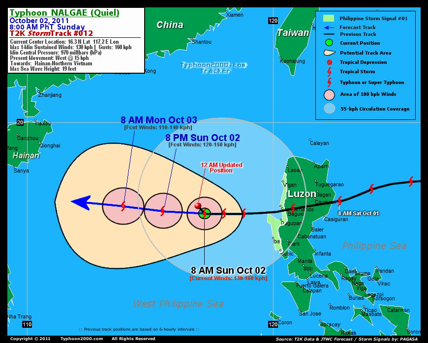
T2K TrackMap (for Public): 12 PM PhT Sun Oct 02
3-DAY FORECAST OUTLOOK & ANALYSIS*
NALGAE (QUIEL) will continue to move toward the WNW...and this general movement will persist throughout the forecast period. On the forecast track, the core of the typhoon will move out of the Philippine Area of Responsibility (PAR) tonight...and will approach the coastal areas of Northern Vietnam & Southern Hainan Tuesday evening.
Maximum Sustained Winds (1-min. avg) are near 130 km/hr (70 knots) with higher gusts. NALGAE is a Category 1 Typhoon on the Saffir-Simpson Tropical Cyclone Scale. Additional weakening is expected within the next 12 to 24 hours as it continues to move over a pool of cooler water...and NALGAE may be downgraded to a Tropical Storm...however, re-intensification back to typhoon status might happen before reaching the coast of Vietnam.
Typhoon Force Winds (118 km/hr or more) extend outward up to 35 kilometers (20 nautical miles) from the center...and Tropical Storm Force Winds (62-117 km/hr) extend outward up to 205 kilometers (110 nautical miles). NALGAE is a large-sized tropical cyclone with a diameter of 720 kilometers (390 nautical miles).
The following is the summary of the 3-day forecast outlook on this system:
 MONDAY MORNING: Downgraded to a Tropical Storm as it exits PAR [8AM OCT 03: 16.6N 113.9E @ 110kph].
TUESDAY MORNING: Regains Typhoon status as it approaches the SE portion of the Gulf of Tonkin [8AM OCT 04: 17.2N 110.9E @ 120kph].
WEDNESDAY MORNING: Loses typhoon strength as it prepares to make landfall along the coast of North-Central Vietnam [8AM OCT 05: 17.8N 108.3E @ 110kph].
*Please be reminded that the Forecast Outlook changes every 6 hours, and the Day 3 Forecast Track have an average error of 250 km...while the wind speed forecast error, averages 35 kph per day. Therefore, a turn to the left or right of its future track and changes in its wind speed must be anticipated from time to time.
EFFECTS & HAZARDS SUMMARY
Below is the summary of the storm's parts and its hazards affecting specific areas:
WEAK & LOOSE EYE - over water (West Philippine Sea). Possible calm and lull conditions (with <20 kph winds) will be expected inside the eye (click here to know more about the EYE).--> WEAK EYEWALL - over water (West Philippine Sea). Typhoon Conditions with Typhoon Force Winds (>118 kph) will be expected within this wall (click here to know more about the Eyewall). INNER RAINBANDS - over water (North Philippine Sea)...not yet affecting any land areas. Tropical Storm Conditions w/ Tropical Storm Force Winds (62-117 kph) will be expected along these bands. OUTER RAINBANDS - its easternmost bands affecting & spreading across Western Luzon. Tropical Depression Conditions w/ moderate to strong winds (25-61 kph) will be expected along these bands (click here to know more about Rainbands). 24HR TOTAL RAINFALL ACCUMULATION - from 5 up to 100 mm (low to high rainfall) can be expected along areas affected by the outer & inner rainbands (see above)...with isolated amounts of 101 to 400 mm (high) along areas near the center of NALGAE (QUIEL). (click to open NOAA's eTRaP graphic). COASTAL STORM SURGE FLOODING - possible 4-5 ft [1.2-1.7 m] above normal tide levels...accompanied by large and dangerous battering waves can be expected along the coastal and beach front areas of Western Luzon with improving sea level conditions later in the day.. Minimal damage is likely on this type of storm surge. Danger from Rip Currents or Rip Tides can be expected along the beach-front areas of Luzon. (click here to know more about Storm Surge).
Important Note: Please keep in mind that the above forecast outlook, effects-hazards, current monsoon intensity, & tropical cyclone watch changes every 6 to 12 hrs!![]()
PAGASA Philippine Storm Warnings Signals
PHILIPPINE STORM WARNING SIGNAL # ONE (1) 
In Effect: ILOCOS SUR, LA UNION, PANGASINAN, & ZAMBALES.
The above areas will have rains and winds of not more than 60 kph today. Coastal waters will be moderate to rough.
Residents living in low-lying and mountainous areas under Public Storm Warning Signals are alerted against flashfloods, mudslides and landslides...while those living in coastal & beach-front areas are advised to seek higher grounds due to possible storm surge (aka. big waves).
External Links for TY NALGAE (QUIEL)
PAGASA@Twitter: Hourly Updates
View NOAA-CIRA's: Latest Full Wind Analysis
JTWC Latest Tracking Chart: wp2211.gif
Multi-Agency Forecast TrackMap: Near Real-Time
TSR Wind Probabilities: Current to 5 Days Ahead
JAXA TRMM Page: Latest Rainrate (in mm/hr)
Zoomed Satellite Pic: NOAA's Near Real-Time
Wunderground Animation: 6-12 hr. GIF Loop
TYPHOON2000 CURRENT STORMTRACK:
>> To know the meteorological terminologies and acronyms used on this update visit the ff:
http://typhoon2000.ph/tcterm.htm
http://www.nhc.noaa.gov/aboutgloss.shtml
http://www.nhc.noaa.gov/acronyms.shtml
__________________________________________________________________________________________
For the complete details on TY NALGAE (QUIEL)...go visit our website @:
> http://www.typhoon2000.com
> http://www.maybagyo.com
Copyright © 2011 Typhoon2000.com All Rights Reserved

No comments:
Post a Comment