
Typhoon2000 (T2K) NEWS (Friday August 03, 2012):
(1) Currently issuing the 6-hrly web, email, & iTyphoon app updates (except 12 Midnight) on SAOLA (GENER); (2) The Track No. 2 (old StormTrack) will only be issued for Tropical Cyclones within the Philippine Area of Responsibility (PAR).
SAOLA MAX WIND SPEED PER AGENCY:
+ USA (JTWC/1-min avg): 85 km/hr
+ Japan (JMA/10-min avg): 75 km/hr
+ Philippines (PAGASA/10-min avg): --- km/hr
+ Beijing (NMC/2-min avg): 100 km/hr
+ Taiwan (CWB/10-min avg): 95 km/hr
+ Korea (KMA/10-min avg): 110 km/hr
+ Hong Kong (HKO/10-min avg): 105 km/hr
:: Click here to see Multi-Agency Forecast Tracks
TYPHOON2000 (T2K) TROPICAL CYCLONE UPDATES
TROPICAL STORM SAOLA (GENER) UPDATE NUMBER 021
5:00 AM PhT (21:00 GMT) Fri 03 August 2012
Sources: T2K Analysis/JTWC TC Warning/SatFixes
View: T2K TC Update Archives (2004-2012)
Tropical Storm SAOLA (GENER) just along the coast of Fujian Province (SE China)...prepares to make landfall. Rapid dissipation expected today. Tropical Storm Conditions affecting Fujian and Zhejiang Provinces.
This storm will continue to enhance the Southwest Monsoon (aka. Habagat) across Metro Manila, Southern Tagalog Provinces, Western Luzon, Mindoro, and Western Visayas today. Breezy to windy conditions & mostly cloudy conditions w/ occasionally passing rains, thunderstorms & squalls will be expected along the abovementioned areas, especially along the western coast. The seas along the coastal areas facing the West, East and North Philippine Seas will be rough and dangerous.
Meanwhile, a new Tropical Depression 12W (Unnamed) has developed over the Western Pacific Ocean, hundreds of kilometers to the north of Guam. A new page will be created on this new system once SAOLA makes landfall over Southeastern China.
Residents and visitors along Southeastern China should closely monitor the progress of Saola (Gener).
Do not use this for life or death decision. This advisory is intended for additional information purposes only. Kindly refer to your country's official weather agency for local warnings, advisories & bulletins.
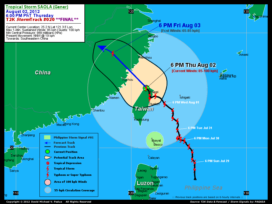
CURRENT STORM INFORMATION
Time/Date: 5:00 AM PhT Fri August 03 2012
Location of Center: 26.5� N Lat 120.2� E Lon
Distance 1: 100 km (ENE) closer to Fuzhou, China
Distance 2: 174 km (SSW) away from Wenzhou, China
Distance 3: 218 km (NW) away from Taipei, Taiwan
MaxWinds (1-min avg): 85 kph (45 kts) near the center
Peak Wind Gusts: 100 kph (55 kts)
Present Movement: WNW @ 15 kph (08 kts)
Towards: Southeastern China
CPA [ETA] to Southeastern China: Ongoing [2AM-Onwards PhT]
NOAA 24hr Rainfall Accum (near center): 210 mm (High)
Minimum Central Pressure: 989 millibars (hPa)
Saffir-Simpson Typhoon Scale: TS
Size (in Diameter): 1,000 km (540 nm) [Very Large]
Wind Area Distribution (in Knots): Current Wind Profile
Max Sea Wave Height (near center): 15 ft
Possible Storm Surge Height: 1-3 ft [0.3-0.9 m]
T2K StormTracks (for Public): Google Map (Flash) | GIF
1-DAY FORECAST OUTLOOK & ANALYSIS*
SAOLA (GENER) is expected to move WNW for the next 12 to 24 hours. On the forecast track, the core of SAOLA will make its final landfall over Fujian Province in Southeastern China this morning...passing to the northeast of Fuzhou City. It will move further across inner mainland China through early Saturday.
Maximum Sustained Winds (1-min. avg) are near 85 km/hr (45 knots) with higher gusts. Rapid dissipation is likely within the next 12 hours as SAOLA moves inland across Southeastern China. The system will be downgraded into a Depression later today...dissipating by Saturday.
Tropical Storm Force Winds (62-100 km/hr) extend outward up to 85 kilometers (45 nautical miles) from the center. SAOLA is a large-sized tropical cyclone with a diameter of 1,000 kilometers (540 nautical miles).
The following is the summary of the 1-day forecast outlook on this system:
 SATURDAY MORNING: Just an area of low pressure as it moves inland across Southeastern China...about 424 km WNW of Wenzhou City [5AM AUG 04: 28.4N 116.4E @ 35kph].
*Please be reminded that the Forecast Outlook changes every 6 hours, and the Day 3 Forecast Track have an average error of 250 km...while the wind speed forecast error, averages 35 kph per day. Therefore, a turn to the left or right of its future track and changes in its wind speed must be anticipated from time to time.
EFFECTS & HAZARDS SUMMARY
Below is the summary of the storm's parts and its hazards affecting specific areas:
INNER RAINBANDS - affecting and spreading across Fujian Province. Tropical Storm Conditions with Tropical Storm Force Winds (62-100 kph) will be expected along these bands. OUTER RAINBANDS - affecting & spreading across the rest of Southeastern China. Cloudy/Rainy Conditions with moderate to strong winds (<62 kph) will be expected along these bands (click here to know more about Rainbands). 24HR TOTAL RAINFALL ACCUMULATION - from 5 up to 100 mm (low to high rainfall) can be expected along areas affected by the outer & inner rainbands (see above)...with isolated amounts of 101 to 210 mm (high) along areas near the center of Saola (Gener) (click to open NOAA's eTRaP graphic). COASTAL STORM SURGE FLOODING - possible 1-3 ft (0.3-0.9 m) above normal tide levels...accompanied by large and dangerous battering waves can be expected along the coastal, inland lakes and beach front areas of Western Taiwan & Southeastern China. Very minimal damage is likely on this type of storm surge. Danger from Rip Currents or Rip Tides can be expected along the rest of the beach-front areas of Eastern & Western Philippines, Okinawa Islands and Southern China (click here to know more about Storm Surge).
TROPICAL CYCLONE WATCH
Typhoon DAMREY (11W) has made landfall over Eastern China and is just a Tropcial Storm, rapidly dissipating overland. Its center was located about 334 km NNW of Shanghai, China (35.3N 118.8E)...with maximum sustained winds of 100 kph and was moving WNW @ 17 kph. To view the latest information on this storm kindly click this link.
CURRENT SW MONSOON INTENSITY: MODERATE >> Sunny to cloudy skies with isolated occasional showers, rains or thunderstorms w/ squalls will be expected along the following affected areas: METRO MANILA, SOUTHERN TAGALOG PROVINCES, WESTERN LUZON, MINDORO, BICOL REGION, & WESTERN VISAYAS. Moderate to strong SW'ly winds (not in excess of 60 kph) will blow across the abovementioned areas.
Important Note: Please keep in mind that the above forecast outlook, effects-hazards, current monsoon intensity, & tropical cyclone watch changes every 6 to 12 hrs!![]()
External Links for TS SAOLA (GENER)
PAGASA: Hourly Updates
View NOAA-CIRA's: Latest Full Wind Analysis
JTWC Latest Tracking Chart: wp1012.gif
Multi-Agency Forecast TrackMap: Near Real-Time
TSR Wind Probabilities: Current to 1 Day Ahead
JAXA TRMM Page: Latest Rainrate (in mm/hr)
NASA TRMM Page: Saola's Rainrate Archives (in mm/hr)
Zoomed Satellite Pic: NOAA's Near Real-Time
Wunderground Animation: 6-12 hr. GIF Loop
CURRENT NOAA/MTSAT-2 SATELLITE IMAGE:

CURRENT TYPHOON2000.COM TRACKING MAP:
_____________________________________________________________________________
>> To know the meteorological terminologies and acronyms used on this update visit the ff:
http://typhoon2000.ph/tcterm.htm
http://www.nhc.noaa.gov/aboutgloss.shtml
http://www.nhc.noaa.gov/acronyms.shtml
__________________________________________________________________________________________
For the complete details on TY SAOLA (GENER)...go visit our website @:
> http://www.typhoon2000.com
> http://www.maybagyo.com
<<<Typhoon2000.com Mobile >>>
Get the latest SMS Storm Alerts!
For more details: Text T2K TYPHOON to
2800 (Globe/TM) | 216 (Smart/TNT) | 2288 (Sun)
*Only P2.50 (Smart/Globe) / P2.00 (Sun) per msg received.
Click here on how to use this service (in PDF file)
Powered by: Synermaxx Corporation
Copyright © 2012 Typhoon2000.com All Rights Reserved

No comments:
Post a Comment