
WEATHER.COM.PH / T2K TROPICAL CYCLONE UPDATES
TYPHOON SON-TINH (OFEL) UPDATE NUMBER 012
Issued: 12:00 NN PhT (04:00 GMT) Saturday 27 Oct 2012
Next Update: 6:00 PM PhT (10:00 GMT) Saturday 27 Oct 2012
Typhoon Son-Tinh (Ofel) moving quickly towards Northern Vietnam...now passing to the south of Hainan Island. Inner rainbands with Tropical Storm Conditions are likely to affect the southern part of Hainan Island and along the northern shores of Central Vietnam this afternoon.
Meanwhile, this system will continue to enhance the Northeast Monsoon (Amihan) and bring on-and-off rains, squalls, thunderstorms across Guangdong Province (China). Winds will be moderate to strong not in excess of 40 km/hr. The sea waves along the coast will be rough and dangerous (8-12 feet).
Residents and visitors along Central and Northern Vietnam including Hainan Island should closely monitor the development of Son-Tinh (Ofel).
Do not use this for life or death decision. This update is intended for additional information purposes only. Kindly refer to your national weather agency for official warnings, advisories or bulletins.
CURRENT STORM ANALYSIS
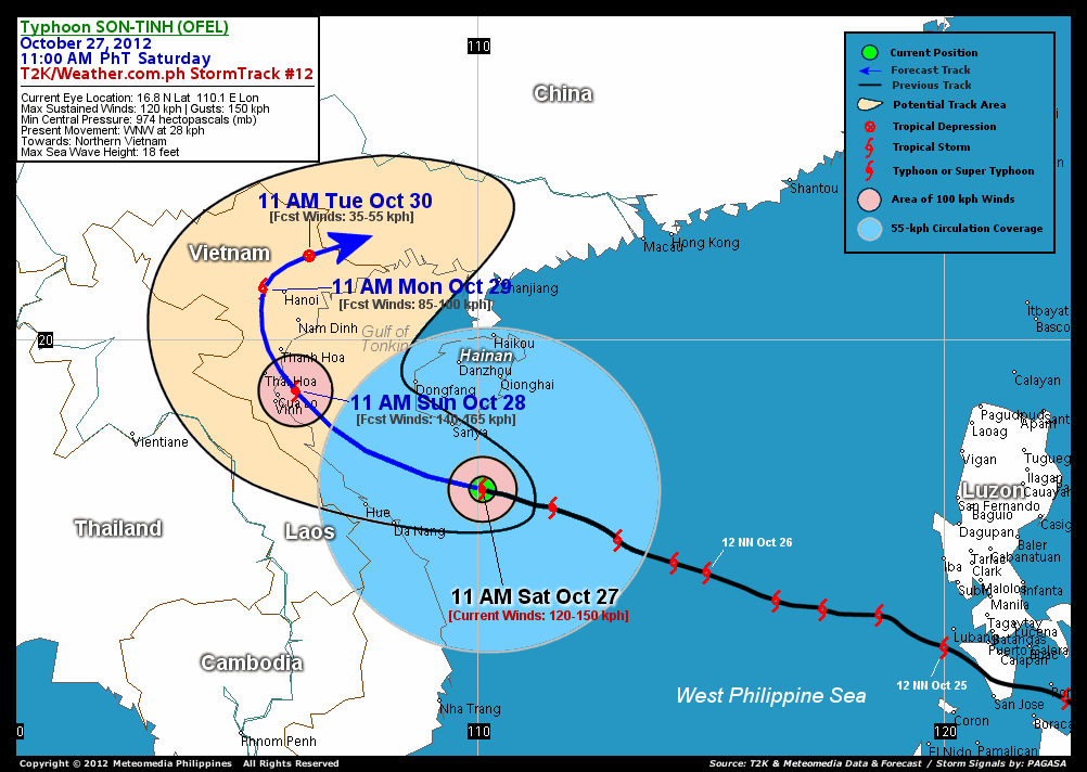
As of 11 am today, the cloud-filled eye of Typhoon Son-Tinh (Ofel) was located just to the south of Hainan Island...about 172 km south-southeast of Sanya, Hainan or 217 km east-northeast of Da Nang, Vietnam...currently moving west-northwest with a forward speed of 28 km/hr in the general direction of Northern Vietnam.
Maximum Sustained Winds (1-min. avg) remain at 120 km/hr near the center with higher gusts. Tropical Storm Force Winds (62-100 km/hr) extend outward up to 160 kilometers from the center. Son-Tinh (Ofel) is a large-sized tropical cyclone with a diameter of 780 kilometers across. The 24-hour rainfall accumulation near the center of Son-Tinh (Ofel) is estimated to be heavy (220 mm).
3-DAY FORECAST OUTLOOK*
Typhoon Son-Tinh (Ofel) is expected to maintain its west-northwest movement during the next 12 hours with a gradual decrease in its forward speed and a turn to the northwest by 24 hours. It will therefore turn northward and recurve northeastward within 48 to 72 hours. On the forecast track, the core of Son-Tinh (Ofel) is expected to pass just south of Hainan Island later this afternoon and will be moving into the Southern Gulf of Tonkin tonight. The typhoon should be along the coast of Northern Vietnam, near the cities of Cua Lo and Vinh Sunday morning...making landfall in between the cities of Thai Hoa and Thanh Hoa late Sunday afternoon or Sunday evening. Son-Tinh (Ofel) is likely to pass just west of Hanoi on Monday morning and over the Vietnamese-Chinese Border on Tuesday afternoon.
This storm is expected to slightly gain strength during the next 24 hours while moving into the southern part of the Gulf of Tonkin...and Son-Tinh (Ofel) could reach peak intensity of 140 km/hr later tonight or Sunday morning. Son-Tinh (Ofel) will start to dissipate as soon as it enters the land mass of Northern Vietnam by late Sunday to Monday...and just be an area of low pressure on Tuesday.
The following is the summary of the 3-day forecast outlook on this system:
 SUNDAY MORNING: Bearing down the coast of Northern Vietnam...prepares to make landfall...about 223 km south-southeast of Hanoi, Vietnam [11AM OCT 28: 18.9N 106.1E @ 140kph].
MONDAY MORNING: Moving over land, across Northern Vietnam...downgraded into a Tropical Storm...about 43 km west of Hanoi, Vietnam [11AM OCT 29: 21.1N 105.4E @ 85kph].
TUESDAY MORNING: Dissipated over land...jusst an area of low pressure near the Vietnamese-Chinese Border...about 103 km north-northeast of Hanoi [11AM OCT 30: 21.8N 106.4E @ 35kph].
*Please be reminded that the Forecast Outlook changes every 6 hours, and the Day 3 Forecast Track have an average error of 250 km...while the wind speed forecast error, averages 35 kph per day. Therefore, a turn to the left or right of its future track and changes in its wind speed must be anticipated from time to time.
EFFECTS & HAZARDS SUMMARY
Below is the summary of the storm's parts and its hazards affecting specific areas. You can also view this image link for you to understand the parts.
CLOUD-FILLED EYE - over water (South China Sea)...not yet affecting any land areas. Possible calm and lull conditions (with <20 kph winds) will be expected inside the eye (click here to know more about the EYE). EYEWALL - over water (South China Sea)...not yet affecting any land areas. Typhoon Conditions with Typhoon Force Winds (>118 kph) will be expected within this wall (click here to know more about the Eyewall). INNER RAINBANDS - affecting and spreading across Southern Hainan and the Coastal Areas of North-Central Vietnam including the cities of Hue and Da Nang. Tropical Storm Conditions with Tropical Storm Force Winds (62-117 kph) will be expected along these bands. OUTER RAINBANDS - affecting and spreading across the rest of Hainan Island, Gulf of Tonkin, Central Vietnam. Tropical Depression Conditions with moderate to strong winds (<62 kph) will be expected along these bands (click here to know more about Rainbands). 24HR TOTAL RAINFALL ACCUMULATION - from 5 up to 100 mm (light to heavy rainfall) can be expected along areas affected by the outer & inner rainbands (see above)...with isolated amounts of 101 to 220 mm (heavy) along areas near the center of Son-Tinh (Ofel). COASTAL STORM SURGE FLOODING - possible 4-5 ft (1.2-1.7 m) above normal tide levels...accompanied by large and dangerous battering waves can be expected along the coastal, inland lakes and beach front areas of Southern Hainan, Northern and Central Vietnam. Minimal damage is likely on this type of storm surge. Danger from Rip Currents or Rip Tides can be expected along the rest of the beach-front areas of Western Philippines, Rest of Hainan Island, Southwestern China and Vietnam (click here to know more about Storm Surge).
Important Note: Please keep in mind that the above forecast outlook, effects and hazards summary changes every 6 to 12 hrs!
CURRENT TECHNICAL INFORMATION
Time/Date: 11:00 AM PhT Sat October 27, 2012
Class/Name: TY Son-Tinh (Ofel)
Location of Eye: 16.8� N Lat 110.1� E Lon
Distance 1: 172 km (SSE) closer to Sanya, Hainan
Distance 2: 217 km (ENE) closer to Da Nang, Vietnam
Distance 3: 268 km (ENE) closer to Hue, Vietnam
Distance 4: 512 km (SE) closer to Vinh, Vietnam
Distance 5: 516 km (SE) closer to Cua Lo, Vietnam
Distance 6: 563 km (SE) closer to Thanh Hoa, Vietnam
Distance 7: 569 km (SE) closer to Thai Hoa, Vietnam
Distance 8: 574 km (SE) closer to Nam Dinh, Vietnam
Distance 9: 643 km (SE) closer to Hanoi, Vietnam
Distance 10: 1,205 km (WNW) away from Metro Manila
MaxWinds (1-min avg): 120 kph near the center
Peak Wind Gusts: 150 kph
Present Movement: WNW @ 28 kph
Towards: Northern Vietnam
24hr Rainfall Accum (near center): Heavy [220 mm]
Minimum Central Pressure: 974 millibars (hPa)
Size (in Diameter): 780 km [Large]
Max Sea Wave Height (near center): 18 feet
Possible Storm Surge Height: 4-5 ft (1.2-1.7 m)
T2K StormTracks (for Public): GIF | Google Map (Flash)

CURRENT NOAA/MTSAT-2 INFRARED SATELLITE IMAGE:

CURRENT TRACKING CHART:
_____________________________________________________________________________
>> To know the meteorological terminologies and acronyms used on this update visit the ff:
http://typhoon2000.ph/tcterm.htm
http://www.nhc.noaa.gov/aboutgloss.shtml
http://www.nhc.noaa.gov/acronyms.shtml
__________________________________________________________________________________________
For the complete details on TY SON-TINH (OFEL)...go visit our website @:
> http://www.typhoon2000.com
> http://www.maybagyo.com
<<<Typhoon2000.com Mobile >>>
Get the latest SMS Storm Alerts!
For more details: Text T2K TYPHOON to
2800 (Globe/TM) | 216 (Smart/TNT) | 2288 (Sun)
*Only P2.50 (Smart/Globe) / P2.00 (Sun) per msg received.
Click here on how to use this service (in PDF file)
Powered by: Synermaxx Corporation
Copyright © 2012 Typhoon2000.com All Rights Reserved
| Reply via web post | Reply to sender | Reply to group | Start a New Topic | Messages in this topic (1) |

No comments:
Post a Comment