
WEATHER.COM.PH / T2K TROPICAL CYCLONE UPDATES
REMNANTS OF T.D. 25W (UNNAMED) UPDATE NUMBER 002 [FINAL]
Issued: 9:00 AM PhT (01:00 GMT) Thursday 15 Nov 2012
Tropical Depression 25W has dissipated into an area of low pressure as it approaches the coast of Southern Vietnam...Rainbands spreading across parts of southern and Central Vietnam.
This is the last and final update on TD 25W.
Do not use this for life or death decision. This update is intended for additional information purposes only. Kindly refer to your national weather agency for official warnings, advisories or bulletins.
CURRENT STORM ANALYSIS
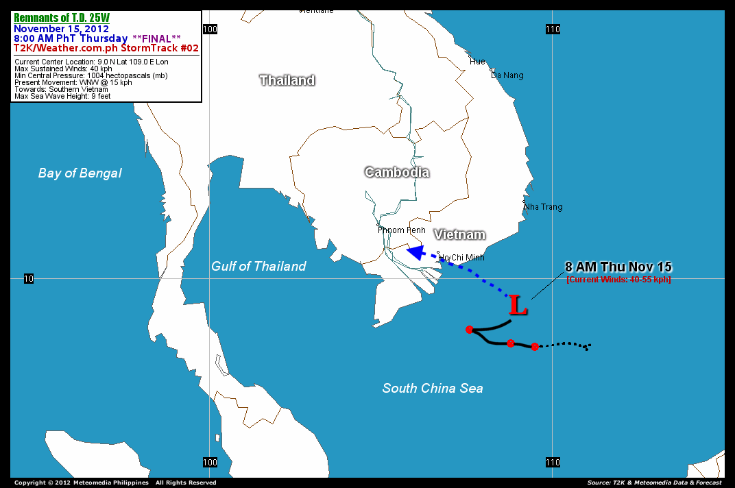
As of 8 am today, the ill-defined center of 25W was located near the southern coast of Vietnam...about 322 km southeast of Ho Chi Minh City, Vietnam...currently moving west-northwest with a forward speed of 15 km/hr in the general direction of the Southern Vietnam.
Maximum Sustained Winds (1-min. avg) have decreased to 40 km/hr near the center with higher gusts. . The 24-hour rainfall accumulation near and to the north of the center of TD 25W is estimated to be extreme (400 mm).
*Please be reminded that the Forecast Outlook changes every 6 hours, and the Day 3 Forecast Track have an average error of 250 km...while the wind speed forecast error, averages 35 kph per day. Therefore, a turn to the left or right of its future track and changes in its wind speed must be anticipated from time to time.
EFFECTS & HAZARDS SUMMARY
Below is the summary of the storm's parts and its hazards affecting specific areas. You can also view this image link for you to understand the parts.
 RAINBANDS - affecting and spreading across Southern and Central parts of Vietnam. Tropical Depression Conditions with moderate to strong winds (<62 kph) will be expected along these bands (click here to know more about Rainbands). 24HR TOTAL RAINFALL ACCUMULATION - from 5 up to 100 mm (slight to heavy rainfall) can be expected along areas affected by the outer & inner rainbands (see above)...with isolated amounts of 201 to 400 mm (heavy to Extreme) along areas near and to the north of the center of 25W.
Important Note: Please keep in mind that the above forecast outlook, effects and hazards summary changes every 6 to 12 hrs!
CURRENT TECHNICAL INFORMATION
Time/Date: 8:00 AM PhT Thu November 15, 2012
Class/Name: Remnants of TD 25W (Unnamed)
Location of Center: 9.0º N Lat 109.0º E Lon
Distance: 322 km (SE) closer to Ho Chi Minh, Vietnam
MaxWinds (1-min avg): 40 kph near the center
Peak Wind Gusts: 55 kph
Present Movement: WNW @ 15 kph
Towards: Southern Vietnam
24hr Rainfall Accum (near center): Extreme [400 mm]
Minimum Central Pressure: 1004 millibars (hPa)
Size (in Diameter): --- km [N/A]
Max Sea Wave Height (near center): 9 feet
Possible Storm Surge Height: 0 ft (0 m)
T2K/WP StormTracks (for Public): GIF | Google Map (Flash)

CURRENT NOAA/MTSAT-2 INFRARED SATELLITE IMAGE:

CURRENT TRACKING CHART:
_____________________________________________________________________________
>> To know the meteorological terminologies and acronyms used on this update visit the ff:
http://typhoon2000.ph/tcterm.htm
http://www.nhc.noaa.gov/aboutgloss.shtml
http://www.nhc.noaa.gov/acronyms.shtml
__________________________________________________________________________________________
For the complete details on Ex-TD 25W (UNNAMED)...go visit our website @:
> http://www.typhoon2000.com
> http://www.maybagyo.com
<<<Typhoon2000.com Mobile >>>
Get the latest SMS Storm Alerts!
For more details: Text T2K TYPHOON to
2800 (Globe/TM) | 216 (Smart/TNT) | 2288 (Sun)
*Only P2.50 (Smart/Globe) / P2.00 (Sun) per msg received.
Click here on how to use this service (in PDF file)
Powered by: Synermaxx Corporation
Copyright © 2012 Typhoon2000.com All Rights Reserved
| Reply via web post | Reply to sender | Reply to group | Start a New Topic | Messages in this topic (1) |

No comments:
Post a Comment