
WEATHER.COM.PH / T2K TROPICAL CYCLONE UPDATES
TROPICAL STORM BOPHA (PABLO) UPDATE NUMBER 040
Issued: 7:00 AM PhT (23:00 GMT) Sunday 09 Dec 2012
Next Update: 1:00 PM PhT (05:00 GMT) Sunday 09 Dec 2012
Bopha (Pablo) rapidly weakened into a Tropical Storm as it lingers near the coast of Ilocos Norte...expected to dissipate later today or Monday.
Residents and visitors along Northern Luzon should closely monitor the development of Bopha (Pablo).
Do not use this for life or death decision. This update is intended for additional information purposes only. Kindly refer to your national weather agency for official warnings, advisories or bulletins.
CURRENT STORM ANALYSIS
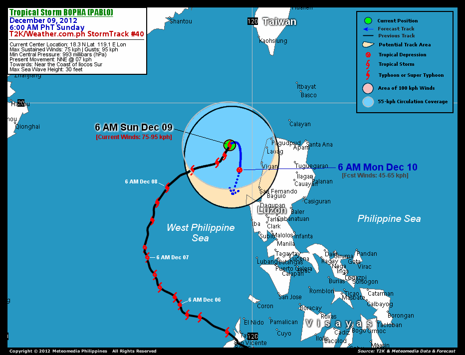
As of 6 am today, the center of Tropical Storm Bopha was located near the coast of Ilocos Norte...about 158 km northwest of Vigan City, Ilocos Sur or 159 km west of San Fernando City, La Union...currently moving north-northeast with a decreased forward speed of 7 km/hr.
Maximum Sustained Winds (1-min. avg) have rapidly decreased to 75 km/hr near the center with higher gusts. Tropical Storm Force Winds (62-117 km/hr) extend outward up to 140 kilometers. Bopha is now a small-sized tropical cyclone with a decreased diameter of 335 kilometers across. The 24-hour rainfall accumulation near the center of TS Bopha is estimated to be heavy (200 mm).
1-DAY FORECAST OUTLOOK*
Tropical Storm Bopha is expected to turn southeast to southward during the next 24 hours. On the forecast track, the center of Bopha is expected to be just near the coast of Ilocos Sur and La Union on Monday morning.
Bopha will continue to weaken and dissipate throughout the forecast period due to the surge of cool dry-air feeding into its circulation and increasing strong winds near the troposphere (known as Vertical Wind Shear) affecting the system.
The following is the summary of the 1-day forecast outlook on this system:
 MONDAY MORNING: Just along the coast of Ilocos Sur...just a weak Tropical Depression dissipating over the West Philippine Sea...about 101 km west-southwest of Vigan City, Ilocos Sur [6AM DEC 10: 17.3N 119.5E @ 45kph].
*Please be reminded that the Forecast Outlook changes every 6 hours, and the Day 3 Forecast Track have an average error of 250 km...while the wind speed forecast error, averages 35 kph per day. Therefore, a turn to the left or right of its future track and changes in its wind speed must be anticipated from time to time.
EFFECTS & HAZARDS SUMMARY
Below is the summary of the storm's parts and its hazards affecting specific areas. You can also view this image link for you to understand the parts.
DECAYING RAINBANDS - affecting and spreading across Ilocos Provinces and the northern portion of La Union. Tropical Depression Conditions with moderate to strong winds (<62 kph) will be expected along these bands (click here to know more about Rainbands). 24HR TOTAL RAINFALL ACCUMULATION - from 5 up to 50 mm (slight to moderate rainfall) can be expected along areas affected by the outer & inner rainbands (see above)...with isolated amounts of 51 to 200 mm (moderate to heavy) along areas near the center of Bopha.
Important Note: Please keep in mind that the above forecast outlook, effects and hazards summary changes every 6 to 12 hrs!
CURRENT TECHNICAL INFORMATION
Time/Date: 6:00 AM PhT Sun December 09, 2012
Class/Name: TS Bopha (Pablo)
Location of Center: 18.3º N Lat 119.1º E Lon
Distance 1: 158 km (NW) from Vigan City
Distance 2: 159 km (W) from Laoag City
Distance 3: 181 km (WSW) from Pagudpud, Ilocos Norte
MaxWinds (1-min avg): 75 kph near the center
Peak Wind Gusts: 95 kph
Present Movement: NNE @ 07 kph
Towards: Near the Coast of Ilocos Sur
24hr Rainfall Accum (near center): Heavy [200 mm]
Minimum Central Pressure: 993 millibars (hPa)
Size (in Diameter): 335 km [Average]
Max Sea Wave Height (near center): 30 feet
Possible Storm Surge Height: 1-2 ft (0.3-0.9 m)
T2K/WP StormTracks (for Public): GIF | Google Map (Flash)

CURRENT NOAA/MTSAT-2 INFRARED SATELLITE IMAGE:

CURRENT TRACKING CHART:
_____________________________________________________________________________
>> To know the meteorological terminologies and acronyms used on this update visit the ff:
http://typhoon2000.ph/tcterm.htm
http://www.nhc.noaa.gov/aboutgloss.shtml
http://www.nhc.noaa.gov/acronyms.shtml
__________________________________________________________________________________________
For the complete details on TS BOPHA (PABLO)...go visit our website @:
> http://www.typhoon2000.com
> http://www.maybagyo.com
<<<Typhoon2000.com Mobile >>>
Get the latest SMS Storm Alerts!
For more details: Text T2K TYPHOON to
2800 (Globe/TM) | 216 (Smart/TNT) | 2288 (Sun)
*Only P2.50 (Smart/Globe) / P2.00 (Sun) per msg received.
Click here on how to use this service (in PDF file)
Powered by: Synermaxx Corporation
Copyright © 2012 Typhoon2000.com All Rights Reserved
| Reply via web post | Reply to sender | Reply to group | Start a New Topic | Messages in this topic (1) |

No comments:
Post a Comment