
WEATHER.COM.PH / T2K TROPICAL CYCLONE UPDATES
TYPHOON BOPHA (PABLO) UPDATE NUMBER 038
Issued: 1:00 PM PhT (05:00 GMT) Saturday 08 Dec 2012
Next Update: 7:00 PM PhT (11:00 GMT) Saturday 08 Dec 2012
Powerful Typhoon Bopha (Pablo) weakens slightly but accelerated northeastward closer to the western shoreline of Ilocos Region and La Union.
Typhoon Alert: With its possible projected path, areas from Ilocos Region down to La Union, Pangasinan, Benguet, and Zambales may experience Tropical Storm Force Winds (63-117 km/hr) with "on-and-off" slight/moderate/heavy rains beginning this evening or Sunday (kindly view the EFFECTS and HAZARDS SUMMARY at the middle bottom of this update). Please take all precautionary measures on this powerful cyclone. Refer to your national disaster agencies for more details.
Residents and visitors along Western Luzon should closely monitor the development of Bopha (Pablo).
Do not use this for life or death decision. This update is intended for additional information purposes only. Kindly refer to your national weather agency for official warnings, advisories or bulletins.
CURRENT STORM ANALYSIS
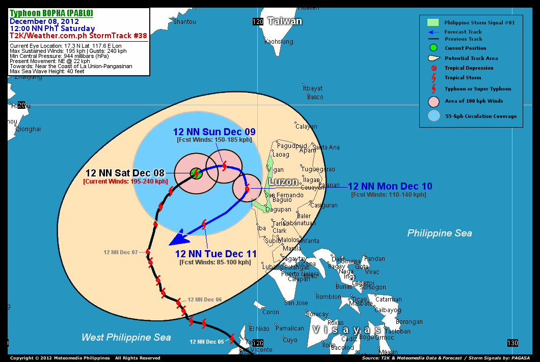
As of 12 noon today, the eye of Typhoon Bopha was located over the West Philippine Sea...about 297 km west-northwest of San Fernando City, La Union or 300 km west-southwest of Vigan City, Ilocos Sur...currently moving northeast with an increased forward speed of 22 km/hr in the general direction near the coasts of Ilocos Sur, La Union and Pangasinan.
Maximum Sustained Winds (1-min. avg) are at 205 km/hr near the center with higher gusts. Typhoon Force Winds (118 km/hr or more) extend outward up to 55 kilometers from the center...and Tropical Storm Force Winds (62-117 km/hr) extend outward up to 215 kilometers. Bopha is an average-sized tropical cyclone with an increased diameter of 555 kilometers across. The 24-hour rainfall accumulation near the center of Tropical Storm Bopha is estimated to be exteme (500 mm).
3-DAY FORECAST OUTLOOK*
Typhoon Bopha is expected to turn east-northeast to eastward during the next 36 hours...with a decrease in its forward speed...and may execute a clockwise loop by way of south beginning Monday until Tuesday. On the forecast track, the core of Bopha is expected to remain over the West Philippine Sea during the next 2 to 3 days but should move closer to the coast of Ilocos Sur, La Union and Pangasinan on Monday, before moving back again into the middle of the West Philippine Sea on Tuesday.
Bopha will continue to weaken throughout the forecast period due to the cool dry-air feeding into its circulation and increasing unfavorable atmospheric environment surrounding the system.
The following is the summary of the 3-day forecast outlook on this system:
 SUNDAY NOON: Moving ENE to East towards Western Luzon's Coast...weakens to Category 1...about 180 km west of Vigan City, Ilocos Sur [12PM DEC 09: 17.6N 118.7E @ 150kph].
MONDAY NOON: Slows down near the coast of La Union and Pangasinan as it executes a clockwise loop...weakens to a Tropical Storm...about 49 km north-northwest of Cape Bolinao, Pangasinan [12PM DEC 10: 16.7N 119.6E @ 110kph].
TUESDAY NOON: Weakens further as it starts to move quickly to the southwest...back towards the West Philippine Sea...about 225 km west of Iba, Zambales [12PM DEC 11: 15.3N 117.9E @ 85kph].
*Please be reminded that the Forecast Outlook changes every 6 hours, and the Day 3 Forecast Track have an average error of 250 km...while the wind speed forecast error, averages 35 kph per day. Therefore, a turn to the left or right of its future track and changes in its wind speed must be anticipated from time to time.
EFFECTS & HAZARDS SUMMARY
Below is the summary of the storm's parts and its hazards affecting specific areas. You can also view this image link for you to understand the parts.
CLOUD-FILLED EYE - over water (West Philippine Sea). Possible calm and lull conditions (with <20 kph winds) will be expected inside the eye (click here to know more about the EYE). EYEWALL - over water (West Philippine Sea). Typhoon Conditions with Typhoon Force Winds (>118 kph) will be expected within this wall (click here to know more about the Eyewall). INNER RAINBANDS - over water (West Philippine Sea)...not affecting any land areas...but could reach the Coastal Areas of Ilocos Region, La Union and Pangasinan on Sunday. Tropical Storm Conditions with Tropical Storm Force Winds (62-117 kph) will be expected along these bands. OUTER RAINBANDS - affecting and spreading across Wesern Pangasinan...likely to reach Ilocos Region, La Union and Rest of Pangasinan later this afternoon or tonight. Tropical Depression Conditions with moderate to strong winds (<62 kph) will be expected along these bands (click here to know more about Rainbands). 24HR TOTAL RAINFALL ACCUMULATION - from 5 up to 200 mm (slight to heavy rainfall) can be expected along areas affected by the outer & inner rainbands (see above)...with isolated amounts of 201 to 550 mm (heavy to extreme) along areas near the center of Bopha. COASTAL STORM SURGE FLOODING - possible 9-12 ft (2.7-3.9 m) above normal tide levels...accompanied by large and dangerous battering waves can be expected along the coastal, inland lakes and beach front areas of Ilocos Region, La Union, Pangasinan and Zambales this weekend through Monday. Extensive damage is likely on this type of storm surge. Danger from Rip Currents or Rip Tides can be expected along the rest of the beach-front areas of Western Visayas and the rest of Western Luzon (click here to know more about Storm Surge).
Important Note: Please keep in mind that the above forecast outlook, effects and hazards summary changes every 6 to 12 hrs!
CURRENT TECHNICAL INFORMATION
Time/Date: 12:00 NN PhT Fri December 07, 2012
Class/Name: TY Bopha (Pablo)
Location of Eye: 17.3º N Lat 117.6º E Lon
Distance 1: 260 km (WNW) from Cape Bolinao, Pangasinan
Distance 2: 297 km (WNW) from San Fernando City
Distance 3: 300 km (WSW) from Vigan City
Distance 4: 322 km (WNW) from Dagupan City
Distance 5: 333 km (WSW) from Laoag City
Distance 6: 335 km (WNW) from Baguio City
Distance 7: 339 km (NW) from Iba, Zambales
Distance 8: 377 km (NW) from Tarlac City
Distance 9: 401 km (NW) from Subic Bay
Distance 10: 487 km (NW) from Metro Manila
MaxWinds (1-min avg): 195 kph near the center
Peak Wind Gusts: 240 kph
Saffir-Simpson Hurricane Scale: Category 3
Present Movement: NE @ 22 kph
Towards: West Philippine Sea
24hr Rainfall Accum (near center): Extreme [520 mm]
Minimum Central Pressure: 944 millibars (hPa)
Size (in Diameter): 555 km [Average]
Max Sea Wave Height (near center): 40 feet
Possible Storm Surge Height: 9-12 ft (2.7-3.9 m)
T2K/WP StormTracks (for Public): GIF | Google Map (Flash)

CURRENT NOAA/MTSAT-2 INFRARED SATELLITE IMAGE:

CURRENT TRACKING CHART:
_____________________________________________________________________________
>> To know the meteorological terminologies and acronyms used on this update visit the ff:
http://typhoon2000.ph/tcterm.htm
http://www.nhc.noaa.gov/aboutgloss.shtml
http://www.nhc.noaa.gov/acronyms.shtml
__________________________________________________________________________________________
For the complete details on TY BOPHA (PABLO)...go visit our website @:
> http://www.typhoon2000.com
> http://www.maybagyo.com
<<<Typhoon2000.com Mobile >>>
Get the latest SMS Storm Alerts!
For more details: Text T2K TYPHOON to
2800 (Globe/TM) | 216 (Smart/TNT) | 2288 (Sun)
*Only P2.50 (Smart/Globe) / P2.00 (Sun) per msg received.
Click here on how to use this service (in PDF file)
Powered by: Synermaxx Corporation
Copyright © 2012 Typhoon2000.com All Rights Reserved
| Reply via web post | Reply to sender | Reply to group | Start a New Topic | Messages in this topic (1) |

No comments:
Post a Comment