
WEATHER.COM.PH / T2K TROPICAL CYCLONE UPDATES
TROPICAL DISTURBANCE 94W (LPA) [BISING] STORMWATCH NUMBER 006
Issued: 7:00 AM PhT (23:00 GMT) Saturday 12 Jan 2013
Next Update: 1:00 PM PhT (05:00 GMT) Saturday 12 Jan 2013
Tropical Disturbance 94W (LPA) [Bising] heading towards the North Philippine Sea...now passing to the east of Catanduanes. Rainbands continues to spread across the Bicol Region & Southern Quezon.
This disturbance will continue to enhance the Northeast Monsoon (Amihan) and bring 15-40 km/hr winds with "on-and-off" slight, moderate to sometimes heavy rains across Luzon including Metro Manila, Marinduque and Mindoro today.
Residents and visitors along Bicol Region and Eastern Luzon should closely monitor the development of 94W (LPA) [BISING].
Do not use this for life or death decision. This update is intended for additional information purposes only. Kindly refer to your national weather agency for official warnings, advisories or bulletins.
CURRENT STORM ANALYSIS
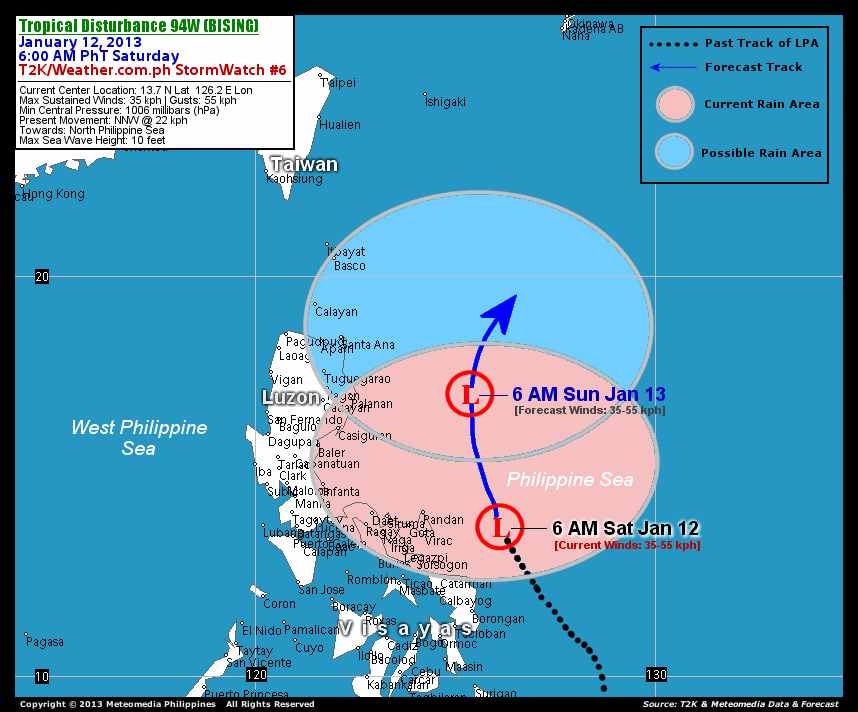
As of 6 AM today, the center of Tropical Disturbance 94W (LPA) [Bising] was located over the Philippine Sea...about 206 km east-northeast of Virac, Catanduanes or 276 km east-northeast of Legazpi City, Albay...currently moving north-northwest with an increased forward speed of 22 km/hr in the general direction of the North Philippine Sea.
Maximum Sustained Winds (1-min. avg) remain at 35 km/hr near the center with higher gusts. The 24-hour rainfall accumulation near the center of 94W (Bising) is estimated to be heavy (250 mm).
1-DAY FORECAST OUTLOOK*
Tropical Disturbance 94W (LPA) [Bising] is expected to continue moving north-northwest with a turn to the north during the next 24 hours. On the forecast track, the core of 94W (LPA) will continue to move across the North Philippine Sea through Sunday...hundreds of kilometers to the east of the Cagayan.
94W is forecast to maintain its strength through the next 24 hours. However, it could also become a weak Tropical Depression (TD) if development occurs.
The following is the summary of the 1-day forecast outlook on this system:
 SUNDAY MORNING: Over the North Philippine Sea...passing well to the east of Northern Luzon...about 319 km east of Palanan, Isabela [6AM JAN 13: 17.0N 125.4E @ 35kph].
*Please be reminded that the Forecast Outlook changes every 6 hours, and the Day 3 Forecast Track have an average error of 250 km...while the wind speed forecast error, averages 35 kph per day. Therefore, a turn to the left or right of its future track and changes in its wind speed must be anticipated from time to time.
EFFECTS & HAZARDS SUMMARY
Below is the summary of the storm's parts and its hazards affecting specific areas. You can also view this image link for you to understand the parts.
RAINBANDS - affecting and spreading across Bicol Region and Southern Quezon. Tropical Disturbance Conditions with light, moderate to strong winds (05-50 kph) will be expected along these bands (click here to know more about Rainbands). 24HR TOTAL RAINFALL ACCUMULATION - from 5 up to 100 mm (slight to heavy rainfall) can be expected along areas affected by the rainbands (see above)...with isolated amounts of 101 to 250 mm (heavy) along areas near the center of 94W (LPA) [Bising].
Important Note: Please keep in mind that the above forecast outlook, effects and hazards summary changes every 6 to 12 hrs!
CURRENT TECHNICAL INFORMATION
Time/Date: 6:00 AM PhT Sat January 12, 2013
Class/Name: LPA 94W (Bising)
Location of Center: 13.7º N Lat 126.2º E Lon
Distance 1: 206 km (ENE) from Virac, Catanduanes
Distance 2: 219 km (NE) from Catarman, N.Samar
Distance 3: 220 km (ESE) from Pandan, Catanduanes
Distance 4: 249 km (NNE) from Borongan City
Distance 5: 261 km (ENE) from Sorsogon City
Distance 6: 276 km (ENE) from Legazpi City
Distance 7: 304 km (ENE) from Iriga City
Distance 8: 324 km (E) from Metro Naga
Distance 9: 359 km (ESE) from Daet, CamNorte
Distance 10: 568 km (ESE) from Metro Manila
MaxWinds (1-min avg): 35 kph near the center
Peak Wind Gusts: 55 kph
Present Movement: NNW @ 22 kph
Towards: North Philippine Sea
24hr Rainfall Accum (near center): Heavy [250 mm]
Minimum Central Pressure: 1006 millibars (hPa)
Max Sea Wave Height (near center): 10 feet
Possible Storm Surge Height: 0 ft (0 m)
T2K/WP StormTracks (for Public): GIF | Google Map (Flash)

CURRENT NOAA/MTSAT-2 INFRARED SATELLITE IMAGE:

CURRENT TRACKING CHART:
_____________________________________________________________________________
>> To know the meteorological terminologies and acronyms used on this update visit the ff:
http://typhoon2000.ph/tcterm.htm
http://www.nhc.noaa.gov/aboutgloss.shtml
http://www.nhc.noaa.gov/acronyms.shtml
__________________________________________________________________________________________
For the complete details on LPA 94W (BISING)...go visit our website @:
> http://www.typhoon2000.com
> http://www.maybagyo.com
<<<Typhoon2000.com Mobile >>>
Get the latest SMS Storm Alerts!
For more details: Text T2K TYPHOON to
2800 (Globe/TM) | 216 (Smart/TNT) | 2288 (Sun)
*Only P2.50 (Smart/Globe) / P2.00 (Sun) per msg received.
Click here on how to use this service (in PDF file)
Powered by: Synermaxx Corporation
Copyright © 2013 Typhoon2000.com All Rights Reserved
| Reply via web post | Reply to sender | Reply to group | Start a New Topic | Messages in this topic (1) |

No comments:
Post a Comment