
WEATHER.COM.PH / T2K TROPICAL CYCLONE UPDATES
TROPICAL DEPRESSION SONAMU (AURING) UPDATE NUMBER 018
Issued: 7:00 PM PhT (11:00 GMT) Tuesday 08 Jan 2013
Next Update: 7:00 AM PhT (23:00 GMT) Wednesday 09 Jan 2013
Sonamu (Auring) weakens anew as it drifts east-southeast towards Western Borneo.
Meanwhile, Tropical Disturbance 94W (LPA) continues to remain almost stationary over the Celebes Sea. Its weak center was located about 444 km south-southeast of Metro Davao (3.9N Lat 128.0E Lon)...with maximum winds of 30 km/hr near the center. This disturbance has a low chance (<30%) of developing into a Tropical Cyclone within the next 24 hours, however, its rainbands together with the active Inter-Tropical Convergence Zone (ITCZ) will continue to bring moderate to heavy rains with thunderstorms along Mindanao especially the regions of SOCCSKSARGEN, ARMM and Davao tonight.
Residents and visitors along Borneo including Brunei should closely monitor the development of Sonamu (Auring).
Do not use this for life or death decision. This update is intended for additional information purposes only. Kindly refer to your national weather agency for official warnings, advisories or bulletins.
CURRENT STORM ANALYSIS
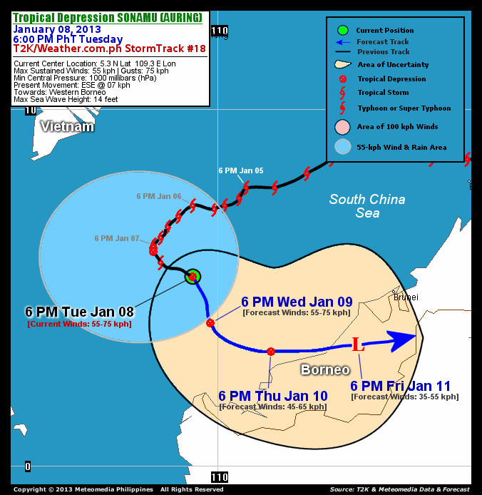
As of 6 PM today, the center of Tropical Depression Sonamu (Auring) was located over the South China Sea...about 622 km west-northwest of Brunei or 665 km south-southeast of Ho Chi Minh City, Vietnam...currently moving east-southeastward with a slow forward speed of 7 km/hr in the general direction of Western Borneo.
Maximum Sustained Winds (1-min. avg) have decreased to 55 km/hr near the center with higher gusts. Sonamu (Auring) remains an average-sized tropical cyclone with a diameter of 350 kilometers across. The 24-hour rainfall accumulation near the center of TS Sonamu is estimated to be extreme (400 mm).
3-DAY FORECAST OUTLOOK*
Tropical Depression Sonamu (Auring) is expected to move southeast to east-southeastward slowly during the next 24 to 48 hours...with a gradual turn to the east throughout the forecast period. On the forecast track, the core of Sonamu (Auring) should continue moving across the open waters of the South China Sea through Thursday morning...approaching the coast of Western Borneo on Thursday evening...and making landfall over Western Borneo on Friday morning.
Sonamu (Auring) is forecast to continue weakening on Thursday...and dissipate into an area of low pressure on Friday, as the system moves inland across Western Borneo.
The following is the summary of the 3-day forecast outlook on this system:
 WEDNESDAY EVENING: Turns south-southeast to southwestward across the South China Sea...about 574 km west-southwest of Brunei [6PM JAN 09: 4.0N 109.8E @ 55kph].
THURSDAY EVENING: Turns eastward as it weakens...just along the west coast of Borneo...about 422 km west-southwest of Brunei [6PM JAN 10: 3.2N 111.5E @ 45kph].
FRIDAY EVENING: Dissipates into an area of low pressure as it makes landfall over Western Borneo and moves over land...about 200 km southwest of Brunei [6PM JAN 11: 3.4N 113.9E @ 35kph].
*Please be reminded that the Forecast Outlook changes every 6 hours, and the Day 3 Forecast Track have an average error of 250 km...while the wind speed forecast error, averages 35 kph per day. Therefore, a turn to the left or right of its future track and changes in its wind speed must be anticipated from time to time.
EFFECTS & HAZARDS SUMMARY
Below is the summary of the storm's parts and its hazards affecting specific areas. You can also view this image link for you to understand the parts.
DECAYING RAINBANDS - affecting and spreading across the coastal areas of Southern Vietnam. Tropical Depression Conditions with light to moderate winds (05-61 kph) will be expected along these bands (click here to know more about Rainbands). 24HR TOTAL RAINFALL ACCUMULATION - from 5 up to 200 mm (slight to heavy rainfall) can be expected along areas affected by the outer & inner rainbands (see above)...with isolated amounts of 201 to 400 mm (heavy to extreme) along areas near the center of TD Sonamu (Auring).
Important Note: Please keep in mind that the above forecast outlook, effects and hazards summary changes every 6 to 12 hrs!
CURRENT TECHNICAL INFORMATION
Time/Date: 6:00 PM PhT Tue January 08, 2013
Class/Name: TD Sonamu (Auring)
Location of Center: 5.3º N Lat 109.3º E Lon
Distance 1: 622 km (WNW) from Brunei
Distance 2: 665 km (SSE) from Ho Chi Minh City
Distance 3: 767 km (S) from Nha Trang, Vietnam
MaxWinds (1-min avg): 55 kph near the center
Peak Wind Gusts: 75 kph
Present Movement: ESE @ 07 kph
Towards: Western Borneo
24hr Rainfall Accum (near center): Extreme [400 mm]
Minimum Central Pressure: 1000 millibars (hPa)
Size (in Diameter): 350 km [Average]
Max Sea Wave Height (near center): 14 feet
Possible Storm Surge Height: 0 ft (0 m)
T2K/WP StormTracks (for Public): GIF | Google Map (Flash)

CURRENT NOAA/MTSAT-2 INFRARED SATELLITE IMAGE:

CURRENT TRACKING CHART:
_____________________________________________________________________________
>> To know the meteorological terminologies and acronyms used on this update visit the ff:
http://typhoon2000.ph/tcterm.htm
http://www.nhc.noaa.gov/aboutgloss.shtml
http://www.nhc.noaa.gov/acronyms.shtml
__________________________________________________________________________________________
For the complete details on TD SONAMU (AURING)...go visit our website @:
> http://www.typhoon2000.com
> http://www.maybagyo.com
<<<Typhoon2000.com Mobile >>>
Get the latest SMS Storm Alerts!
For more details: Text T2K TYPHOON to
2800 (Globe/TM) | 216 (Smart/TNT) | 2288 (Sun)
*Only P2.50 (Smart/Globe) / P2.00 (Sun) per msg received.
Click here on how to use this service (in PDF file)
Powered by: Synermaxx Corporation
Copyright © 2013 Typhoon2000.com All Rights Reserved
| Reply via web post | Reply to sender | Reply to group | Start a New Topic | Messages in this topic (1) |

No comments:
Post a Comment