
WEATHER.COM.PH / T2K TROPICAL CYCLONE UPDATES
TROPICAL STORM SONAMU (AURING) UPDATE NUMBER 005
Issued: 1:00 PM PhT (05:00 GMT) Friday 04 Jan 2013
Next Update: 7:00 PM PhT (11:00 GMT) Friday 04 Jan 2013
Tropical Storm Sonamu (Auring) has slowed down while over the West Philippine Sea...now moving away from Palawan.
This storm will continue to enhance the Northeast Monsoon (Amihan) and bring "on-and-off" slight, moderate to heavy rains across the Rest of Visayas, Northern Mindanao, Eastern & Central Luzon including Mindoro, and Bicol Region.
Residents and visitors along Spratly Islands and Southern Vietnam should closely monitor the development of Sonamu (Auring).
Do not use this for life or death decision. This update is intended for additional information purposes only. Kindly refer to your national weather agency for official warnings, advisories or bulletins.
CURRENT STORM ANALYSIS
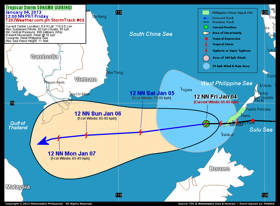
As of 12 noon today, the center of Tropical Storm Sonamu (Auring) was located over the West Philippine Sea...about 176 km west of Bataraza, Palawan or 335 km southeast of Pagasa Island, Spratlys...currently moving west with a decreased forward speed of 19 km/hr in the general direction of the West Philippine Sea.
Maximum Sustained Winds (1-min. avg) remain at 65 km/hr near the center with higher gusts. Sonamu (Auring) is a small-to-average-sized tropical cyclone with a diameter of 335 kilometers across. The 24-hour rainfall accumulation near the center and to the northwest of TS Sonamu is estimated to be heavy (220 mm).
3-DAY FORECAST OUTLOOK*
Tropical Storm Sonamu (Auring) is expected to move west to west-southwestward throughout the forecast period. On the forecast track, the core of Sonamu (Auring) is expected to move across the West Philippine Sea and exit the Philippine Area of Responsibility (PAR) tonight. It should be approaching the Gulf of Thailand while passing well to the south of Vietnam on Sunday through Monday.
Sonamu (Auring) is forecast to slightly strengthen on Saturday...before losing strength beginning Sunday through Monday.
The following is the summary of the 3-day forecast outlook on this system:
 SATURDAY NOON: Intensifies slightly while moving west-southwest across the South China Sea...about 671 km southeast of Ho Chi Minh City, Vietnam [12PM JAN 05: 8.0N 111.5E @ 75kph].
SUNDAY NOON: Starts to weaken as it approaches the Gulf of Thailand...about 365 km south-southeast of Ho Chi Minh City [12PM JAN 06: 7.8N 107.8E @ 65kph].
MONDAY NOON: Maintains its Tropical Storm strength as it moves across the Gulf of Thailand...about 377 km south-southwest of Ho Chi Minh City [12PM JAN 07: 7.6N 105.9E @ 65kph].
EFFECTS & HAZARDS SUMMARY
Below is the summary of the storm's parts and its hazards affecting specific areas. You can also view this image link for you to understand the parts.
INNER RAINBANDS - over water (West Philippine Sea)...not affecting any land areas. Tropical Storm Conditions with Tropical Storm Force Winds (62-85 kph) will be expected along these bands. OUTER RAINBANDS - affecting and spreading across Palawan, Spratly Islands and Borneo. Tropical Depression Conditions with light to moderate winds (5-61 kph) will be expected along these bands (click here to know more about Rainbands). 24HR TOTAL RAINFALL ACCUMULATION - from 5 up to 100 mm (slight to heavy rainfall) can be expected along areas affected by the developing rainbands (see above)...with isolated amounts of 101 to 220 mm (heavy) along areas near, north and west of the center of TS Sonamu (Auring).
Important Note: Please keep in mind that the above forecast outlook, effects and hazards summary changes every 6 to 12 hrs!
CURRENT TECHNICAL INFORMATION
Time/Date: 12:00 NN PhT Fri January 04, 2013
Class/Name: TS Sonamu (Auring)
Location of Center: 8.6º N Lat 116.0º E Lon
Distance 1: 138 km (WNW) away from Balabac, Palawan
Distance 2: 176 km (W) away from Bataraza, Palawan
Distance 3: 199 km (W) away from Brooke's Point, Palawan
Distance 4: 275 km (WSW) away from Narra, Palawan
Distance 5: 321 km (WSW) away from Puerto Princesa
Distance 6: 335 km (SE) from Pagasa Is., Spratlys
MaxWinds (1-min avg): 65 kph near the center
Peak Wind Gusts: 85 kph
Present Movement: West @ 19 kph
Towards: West Philippine Sea
24hr Rainfall Accum (near center): Heavy [230 mm]
Minimum Central Pressure: 998 millibars (hPa)
Size (in Diameter): 335 km [Small/Average]
Max Sea Wave Height (near center): 11 feet
Possible Storm Surge Height: 1-3 ft (0.3-0.9 m)
T2K/WP StormTracks (for Public): GIF | Google Map (Flash)

CURRENT NOAA/MTSAT-2 INFRARED SATELLITE IMAGE:

CURRENT TRACKING CHART:
_____________________________________________________________________________
>> To know the meteorological terminologies and acronyms used on this update visit the ff:
http://typhoon2000.ph/tcterm.htm
http://www.nhc.noaa.gov/aboutgloss.shtml
http://www.nhc.noaa.gov/acronyms.shtml
__________________________________________________________________________________________
For the complete details on TS SONAMU (AURING)...go visit our website @:
> http://www.typhoon2000.com
> http://www.maybagyo.com
<<<Typhoon2000.com Mobile >>>
Get the latest SMS Storm Alerts!
For more details: Text T2K TYPHOON to
2800 (Globe/TM) | 216 (Smart/TNT) | 2288 (Sun)
*Only P2.50 (Smart/Globe) / P2.00 (Sun) per msg received.
Click here on how to use this service (in PDF file)
Powered by: Synermaxx Corporation
Copyright © 2013 Typhoon2000.com All Rights Reserved
| Reply via web post | Reply to sender | Reply to group | Start a New Topic | Messages in this topic (1) |

No comments:
Post a Comment