
WEATHER.COM.PH TROPICAL CYCLONE UPDATES
TROPICAL DEPRESSION 06W (GORIO) UPDATE NUMBER 002
Issued: 7:00 PM PhT (11:00 GMT) Friday 28 June 2013
Next Update: 7:00 AM PhT (23:00 GMT) Saturday 29 June 2013
Tropical Depression 06W (GORIO) has gained strength slightly as it headed towards Samar and Bicol Area. Its rainbands now affecting Eastern Visayas, Northeastern Mindanao and Bicol Region.
This depression will enhance the Southwest Monsoon (Hanging Habagat) and bring windy/cloudy conditions with occasionally slight to moderate to sometimes heavy rains and thunderstorms across Mindanao, particularly Zamboanga Peninsula tonight...and across Western Visayas on Saturday.
Residents and visitors along Eastern Visayas, Bicol and Luzon should closely monitor the development of 06W (GORIO).
Do not use this for life or death decision. This update is intended for additional information purposes only. Kindly refer to your national weather agency for official warnings, advisories or bulletins.
CURRENT STORM ANALYSIS
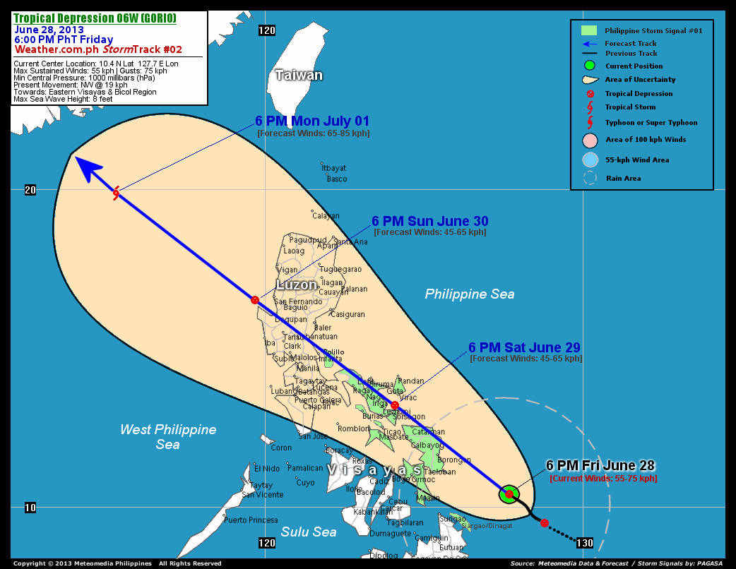
As of 6:00 pm today, the center of TD 06W (Gorio) was located over the southern part of the Philippine Sea...about 250 km east-northeast of Surigao City, Surigao del Norte or 284 km southeast of Borongan City, Eastern Samar...currently moving northwest with an accelerated forward speed of 19 km/hr in the general direction of the Samar and Bicol Region.
Maximum Sustained Winds (1-min. avg) have increased to 55 km/hr near the center with higher gusts. The 24-hour rainfall accumulation near the center of 06W (Gorio) is estimated to be heavy (300 mm).
3-DAY FORECAST OUTLOOK*
TD 06W (Gorio) is expected to continue moving northwest throughout the forecast period. On the forecast track, the core of 06W (Gorio) will traverse the northeastern part of Samar Island Saturday morning...and will be passing along the eastern shoreline of Sorsogon-Albay-Camarines Sur, cutting across Partido District (Camarines Sur) and Camarines Norte on Saturday evening until midnight. 06W will then be passing over or very close to Polillo Island on Sunday morning, making landfall over Northern Quezon-Aurora Area before Sunday noon...and cross Central Luzon Sunday afternoon. By Sunday evening, the depression will be just along the coast of La Union or over the West Philippine Sea...and will exit the Philippine Area of Responsibility (PAR) on Monday morning.
06W (Gorio) is forecast to maintain its strength for the next 12 hours...weakening slightly through the next 24 to 48 hours due to its interaction with the land mass of Luzon. Once the system reaches the West Philippine Sea on Sunday evening, it will re-intensify and could become a Tropical Storm (TS) on Monday.
The following is the summary of the 3-day forecast outlook on this system:
 SATURDAY EVENING: Over Albay Gulf...about 43 km east of Legazpi City, Albay [6PM JUNE 29: 13.2N 124.1E @ 45kph].
SUNDAY EVENING: Over the west coast of La Union, near Cape Bolinao, Pangasinan...about 97 km west of Baguio City [6PM JUNE 30: 16.5N 119.7E @ 45kph].
MONDAY EVENING: Over the South China Sea...approaching Southern China...becomes a TS...about 280 km southeast of Hong Kong [6PM JULY 01: 19.9N 115.3E @ 65kph].
*Please be reminded that the Forecast Outlook changes every 6 hours, and the Day 3 Forecast Track have an average error of 250 km...while the wind speed forecast error, averages 35 kph per day. Therefore, a turn to the left or right of its future track and changes in its wind speed must be anticipated from time to time.
EFFECTS & HAZARDS SUMMARY
Below is the summary of the storm's parts and its hazards affecting specific areas. You can also view this image link for you to understand the parts.
DEVELOPING RAINBANDS - spreading across the southern part of the Philippine Sea, Eastern Visayas, Northeastern Mindanao and Bicol Region. Affected Areas: Samar, Leyte, Sorsogon, Albay, Catanduanes, Camarines Provinces, Masbate, Burias and Ticao Islands, Surigao Del Norte incl. Dinagat and Siargao Islands, and Bohol. Tropical Depression Conditions with light, moderate to strong winds (30-62 kph) will be expected along these bands (click here to know more about Rainbands). 24HR TOTAL RAINFALL ACCUMULATION - from 5 up to 200 mm (slight to heavy rainfall) can be expected along areas affected by the outer & inner rainbands (see above)...with isolated amounts of 201 to 300 mm (heavy) along areas to the south, west and near the center of 06W (Gorio).
Important Note: Please keep in mind that the above forecast outlook, effects and hazards summary changes every 6 to 12 hrs!
CURRENT TECHNICAL INFORMATION
Time/Date: 6:00 PM PhT Fri June 28, 2013
Class/Name: TD 06W (Gorio)
Location of Center: 10.4º N Lat 127.7º E Lon
Distance 1: 250 km ENE of Surigao City
Distance 2: 284 km SE of Borongan City
Distance 3: 308 km ESE of Tacloban City
Distance 4: 317 km E of Maasin City
Distance 5: 411 km SE of Catarman, N.Samar
Distance 6: 496 km SE of Sorsogon City
Distance 7: 521 km SE of Virac, Catanduanes
Distance 8: 535 km SE of Legazpi City
Distance 9: 605 km SE of Metro Naga
Distance 10: 790 km SE of Polillo Is.
MaxWinds (1-min avg): 55 kph near the center
Peak Wind Gusts: 75 kph
Present Movement: NW @ 19 kph
Towards: Samar and Bicol Region
24hr Rainfall Accum (near center): Heavy [300 mm]
Minimum Central Pressure: 1000 millibars (hPa)
Max Sea Wave Height (near center): 8 feet
Possible Storm Surge Height: 0 ft (0 m)
T2K/WP StormTracks (for Public): GIF | Google Map (Flash)

CURRENT NOAA/MTSAT-2 INFRARED (IR) SATELLITE IMAGE:

CURRENT TRACKING MAP:
 _____________________________________________________________________________
>> To know the meteorological terminologies and acronyms used on this update visit the ff:
http://typhoon2000.ph/tcterm.htm
http://www.nhc.noaa.gov/aboutgloss.shtml
http://www.nhc.noaa.gov/acronyms.shtml
__________________________________________________________________________________________
For the complete details on TD 06W (GORIO)...go visit our website @:
> http://www.typhoon2000.com
> http://www.maybagyo.com
<<<Typhoon2000.com Mobile >>>
Get the latest SMS Storm Alerts!
For more details: Text T2K TYPHOON to
2800 (Globe/TM) | Offline (Smart/TNT) | 2288 (Sun)
*Only P2.50 (Smart/Globe) / P2.00 (Sun) per msg received.
Click here on how to use this service (in PDF file)
Powered by: Synermaxx Corporation
Copyright © 2013 Typhoon2000.com All Rights Reserved
| Reply via web post | Reply to sender | Reply to group | Start a New Topic | Messages in this topic (1) |

No comments:
Post a Comment