
WEATHER.COM.PH TROPICAL CYCLONE UPDATES
TROPICAL DEPRESSION 94W (FABIAN) UPDATE NUMBER 002
Issued: 7:00 PM PhT (11:00 GMT) Thursday 20 June 2013
Next Update: 7:00 AM PhT (23:00 GMT) Friday 21 June 2013
Tropical Depression 94W (FABIAN) has moved north-northeast during the past 6 hours while over the West Philippine Sea with no change in strength...expected to move out of the Philippine Area of Responsibility (PAR) on Friday.
This depression will continue to enhance the Southwest Monsoon (Hanging Habagat) and could bring windy/cloudy conditions with occasionally slight to moderate to sometimes heavy rains and thunderstorms across Metro Manila, MiMaRoPa, and Western Luzon tonight and Friday. Flash floods and landslides are likely in hazard-prone areas especially along mountain slopes.
Residents and visitors along the western coast of Luzon, from Ilocos Region down to Pangasinan should closely monitor the development of 94W (FABIAN).
Do not use this for life or death decision. This update is intended for additional information purposes only. Kindly refer to your national weather agency for official warnings, advisories or bulletins.
CURRENT STORM ANALYSIS
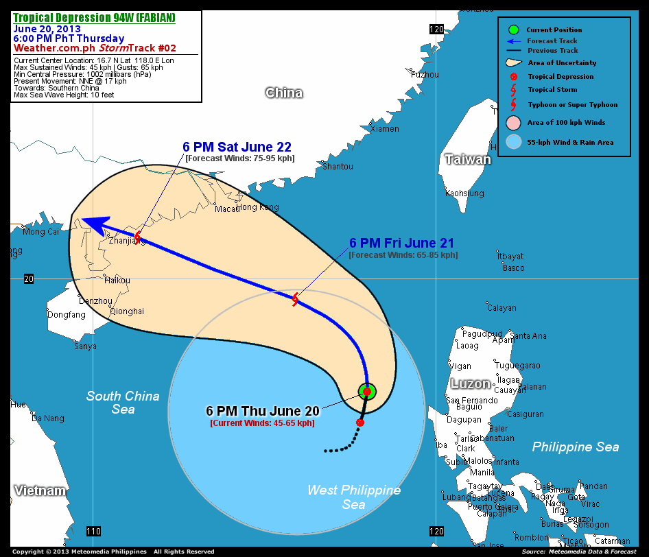
As of 6:00 pm today, the center of TD 94W (Fabian) was located over the West Philippine Sea...about 197 km west-northwest of Cape Bolinao, Pangasinan or 274 km west-southwest of Vigan City, Ilocos Sur...currently moving north-northeast with an increased forward speed of 17 km/hr.
Maximum Sustained Winds (1-min. avg) remains at 45 km/hr near the center with higher gusts. The 24-hour rainfall accumulation near the center of 94W (Fabian) is estimated to be heavy (300 mm).
2-DAY FORECAST OUTLOOK*
TD 94W (Fabian) is expected to move north-northwest to northwest within the next 12 hours...and then turn towards the west-northwest between 24 to 48 hours. On the forecast track, the core of 94W (Fabian) will remain over the West Philippine Sea until Friday morning...and will exit the Philippine Area of Responsibility. On Saturday evening, the depression will be just along the coast of Western Guangdong in Southern China...making landfall just east of Zhanjiang City.
94W (Fabian) is forecast to gain strength during the next 24 to 48 hours...and could become a Tropical Storm (TS) on Friday.
The following is the summary of the 2-day forecast outlook on this system:
 FRIDAY EVENING: Becomes a TS as it moves across the South China Sea, outside of the PAR...about 358 km southeast of Hong Kong [6PM JUNE 21: 19.4N 115.9E @ 65kph].
SATURDAY EVENING: Reaches its peak winds of 75 km/hr as it approaches the shores of Western Guangdong...about 84 km east of Zhanjiang City, China [6PM JUNE 22: 21.2N 111.3E @ 75kph].
*Please be reminded that the Forecast Outlook changes every 6 hours, and the Day 3 Forecast Track have an average error of 250 km...while the wind speed forecast error, averages 35 kph per day. Therefore, a turn to the left or right of its future track and changes in its wind speed must be anticipated from time to time.
EFFECTS & HAZARDS SUMMARY
Below is the summary of the storm's parts and its hazards affecting specific areas. You can also view this image link for you to understand the parts.
DEVELOPING RAINBANDS - spreading across the West Philippine Sea. Affected Areas: Scarborough Shoal. Tropical Depression Conditions with light, moderate to strong winds (30-63 kph) will be expected along these bands (click here to know more about Rainbands). 24HR TOTAL RAINFALL ACCUMULATION - from 5 up to 100 mm (slight to heavy rainfall) can be expected along areas affected by the outer & inner rainbands (see above)...with isolated amounts of 101 to 300 mm (heavy) along areas to the south and near the center of 94W (Fabian).
Important Note: Please keep in mind that the above forecast outlook, effects and hazards summary changes every 6 to 12 hrs!
CURRENT TECHNICAL INFORMATION
Time/Date: 6:00 PM PhT Thu June 20, 2013
Class/Name: TD 94W (Fabian)
Location of Center: 16.7º N Lat 118.0º E Lon
Distance 1: 197 km WNW of Cape Bolinao, Pangasinan
Distance 2: 245 km W of San Fernando City
Distance 3: 257 km WNW of Dagupan City
Distance 4: 264 km NW of Iba, Zambales
Distance 5: 274 km WSW of Vigan City
Distance 6: 279 km WNW of Baguio City
Distance 7: 322 km SW of Laoag City
Distance 8: 324 km NW of Subic Bay
Distance 9: 412 km NW of Metro Manila
Distance 10: 730 km SSE of Hong Kong
MaxWinds (1-min avg): 45 kph near the center
Peak Wind Gusts: 65 kph
Present Movement: NNE @ 17 kph
Towards: Southern China
24hr Rainfall Accum (near center): Heavy [300 mm]
Minimum Central Pressure: 1002 millibars (hPa)
Max Sea Wave Height (near center): 10 feet
Possible Storm Surge Height: 0 ft (0 m)
T2K/WP StormTracks (for Public): GIF | Google Map (Flash)

CURRENT NOAA/MTSAT-2 INFRARED (IR) SATELLITE IMAGE:

CURRENT TRACKING MAP:
 _____________________________________________________________________________
>> To know the meteorological terminologies and acronyms used on this update visit the ff:
http://typhoon2000.ph/tcterm.htm
http://www.nhc.noaa.gov/aboutgloss.shtml
http://www.nhc.noaa.gov/acronyms.shtml
__________________________________________________________________________________________
For the complete details on TD 94W (FABIAN)...go visit our website @:
> http://www.typhoon2000.com
> http://www.maybagyo.com
<<<Typhoon2000.com Mobile >>>
Get the latest SMS Storm Alerts!
For more details: Text T2K TYPHOON to
2800 (Globe/TM) | Offline (Smart/TNT) | 2288 (Sun)
*Only P2.50 (Smart/Globe) / P2.00 (Sun) per msg received.
Click here on how to use this service (in PDF file)
Powered by: Synermaxx Corporation
Copyright © 2013 Typhoon2000.com All Rights Reserved
| Reply via web post | Reply to sender | Reply to group | Start a New Topic | Messages in this topic (1) |

No comments:
Post a Comment