
WEATHER.COM.PH TROPICAL CYCLONE UPDATES
TROPICAL STORM YAGI (DANTE) UPDATE NUMBER 004
Issued: 7:00 AM PhT (23:00 GMT) Monday 10 Jun 2013
Next Update: 1:00 PM PhT (05:00 GMT) Monday 10 Jun 2013
Tropical Storm YAGI (DANTE) moving northeastward with no change in its strength...expected to move out of the Philippine Area of Responsibility (PAR) tonight.
Residents and visitors along Southern Japan should closely monitor the development of YAGI (DANTE).
Do not use this for life or death decision. This update is intended for additional information purposes only. Kindly refer to your national weather agency for official warnings, advisories or bulletins.
CURRENT STORM ANALYSIS
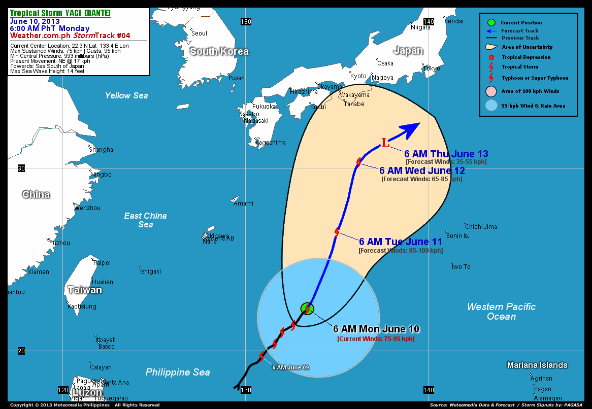
As of 6:00 am today, the center of Tropical Storm Yagi (Dante) was located over the northeastern part of the Philippine Sea...about 734 km southeast of Okinawa, Japan or 1,197 km east-northeast of Basco, Batanes...currently moving northeast with a forward speed of 17 km/hr in the general direction of the Sea South of Japan.
Maximum Sustained Winds (1-min. avg) remains at 75 km/hr near the center with higher gusts. The 24-hour rainfall accumulation near the center of Yagi (Dante) is estimated to be heavy (350 mm).
3-DAY FORECAST OUTLOOK*
TS Yagi (Dante) is expected to move north-northeast during the next 24 hours, with a turn to the northeast or east-northeast between 48 to 72 hours. On the forecast track, the core of Yagi (Dante) will exit the Philippine Area of Responsibility (PAR) tonight and will be just along the open waters of the Northwest Pacific, south of Japan through Thursday morning.
Yagi (Dante) is forecast to gain strength during the next 24 hours reaching a peak of 85 kph on Tuesday morning...but will start to weaken on Wednesday morning, dissipating into an area of low pressure on Thursday morning.
The following is the summary of the 3-day forecast outlook on this system:
 TUESDAY MORNING: Intensifies slightly while over the Northwest Pacific Ocean...outside of PAR...about 716 km east of Okinawa, Japan [6AM JUN 11: 26.5N 135.0E @ 85kph].
WEDNESDAY MORNING: Moving north-northeastward across the sea south of Japan...about 385 km south-southeast of Tanabe, Japan [6AM JUN 12: 30.3N 136.2E @ 65kph].
THURSDAY MORNING: Dissipating over the sea south of Japan...just an area of low pressure...about 328 km southeast of Tanabe, Japan [6AM JUN 13: 31.4N 137.6E @ 35kph].
*Please be reminded that the Forecast Outlook changes every 6 hours, and the Day 3 Forecast Track have an average error of 250 km...while the wind speed forecast error, averages 35 kph per day. Therefore, a turn to the left or right of its future track and changes in its wind speed must be anticipated from time to time.
EFFECTS & HAZARDS SUMMARY
Below is the summary of the storm's parts and its hazards affecting specific areas. You can also view this image link for you to understand the parts.
RAINBANDS - spreading across the Philippine Sea and Northwest Pacific Ocean. Affected Areas: None. Tropical Depression Conditions with light, moderate to strong winds (30-60 kph) will be expected along these bands (click here to know more about Rainbands). 24HR TOTAL RAINFALL ACCUMULATION - from 5 up to 200 mm (slight to heavy rainfall) can be expected along areas affected by the rainbands (see above)...with isolated amounts of 201 to 350 mm (heavy) along areas to the south and near the center of Yagi (Dante).
Important Note: Please keep in mind that the above forecast outlook, effects and hazards summary changes every 6 to 12 hrs!
CURRENT TECHNICAL INFORMATION
Time/Date: 6:00 AM PhT Mon June 10, 2013
Class/Name: TS Yagi (Dante)
Location of Center: 22.3º N Lat 133.4º E Lon
Distance 1: 734 km SE of Okinawa, Japan
Distance 2: 779 km SSE of Amami Is., Japan
Distance 3: 1,073 km SSE of Kagoshima, Japan
Distance 4: 1,197 km ENE of Basco, Batanes
Distance 5: 1,245 km S of Kochi, Japan
MaxWinds (1-min avg): 75 kph near the center
Peak Wind Gusts: 95 kph
Present Movement: NE @ 17 kph
Towards: Seas South of Japan
24hr Rainfall Accum (near center): Heavy [350 mm]
Minimum Central Pressure: 993 millibars (hPa)
Size (in Diameter): 555 km [Average]
Max Sea Wave Height (near center): 14 feet
Possible Storm Surge Height: 0 ft (0 m)
T2K/WP StormTracks (for Public): GIF | Google Map (Flash)

CURRENT NOAA/MTSAT-2 INFRARED (IR) SATELLITE IMAGE:

CURRENT TRACKING MAP:
 _____________________________________________________________________________
>> To know the meteorological terminologies and acronyms used on this update visit the ff:
http://typhoon2000.ph/tcterm.htm
http://www.nhc.noaa.gov/aboutgloss.shtml
http://www.nhc.noaa.gov/acronyms.shtml
__________________________________________________________________________________________
For the complete details on TS YAGI (DANTE)...go visit our website @:
> http://www.typhoon2000.com
> http://www.maybagyo.com
<<<Typhoon2000.com Mobile >>>
Get the latest SMS Storm Alerts!
For more details: Text T2K TYPHOON to
2800 (Globe/TM) | Offline (Smart/TNT) | 2288 (Sun)
*Only P2.50 (Smart/Globe) / P2.00 (Sun) per msg received.
Click here on how to use this service (in PDF file)
Powered by: Synermaxx Corporation
Copyright © 2013 Typhoon2000.com All Rights Reserved
| Reply via web post | Reply to sender | Reply to group | Start a New Topic | Messages in this topic (1) |

No comments:
Post a Comment