
WEATHER.COM.PH TROPICAL CYCLONE UPDATES
TROPICAL DEPRESSION 08W (ISANG) UPDATE NUMBER 001
Issued: 7:00 AM PhT (23:00 GMT) Tuesday 16 July 2013
Next Update: 1:00 PM PhT (05:00 GMT) Tuesday 16 July 2013
The strong but small Tropical Disturbance (LPA) [93W] near the Bicol Region has strengthened into Tropical Depression (TD) 08W...and is now locally named as "ISANG." Initial forecast shows a track towards Cagayan-Batanes Area within the next 24 hours. Its developing rainbands are affecting the Bicol Region and Northern Samar, where occasional slight, moderate to sometimes heavy rains will be expected.
Residents and visitors along Central and Northern Luzon incl. Batanes-Calayan-Babuyan Islands, and Taiwan should closely monitor the development of 08W (Isang).
Do not use this for life or death decisions. This update is intended for additional information purposes only. Kindly refer to your national weather agency for official warnings, advisories or bulletins.
CURRENT STORM ANALYSIS
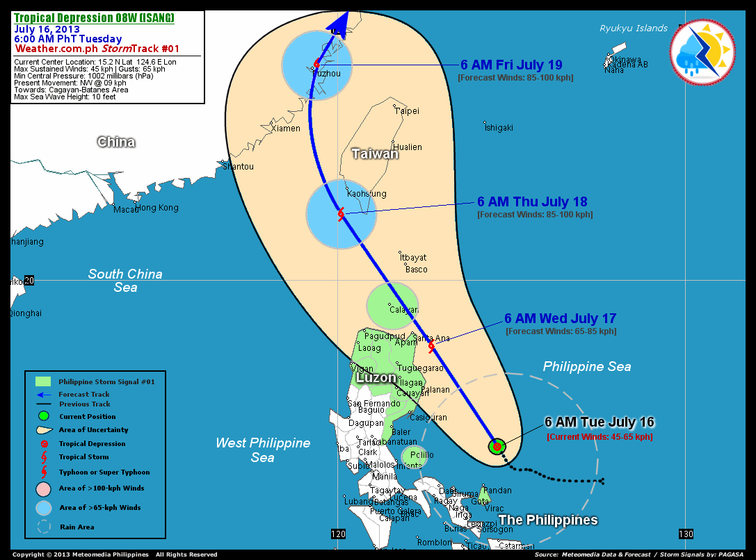
As of 6:00 am today, the center of TD 08W (Isang) was located over the Central Philippine Sea...about 185 km north of Virac, Catanduanes or 235 km northeast of Metro Naga, Camarines Sur...currently moving northwest with a slow forward speed of 09 km/hr in the general direction of Cagayan-Batanes Area.
Maximum Sustained Winds (1-min. avg) are near 45 km/hr near the center with higher gusts. . 08W (Isang) is a small-sized tropical cyclone with a diameter of 300 kilometers across. The 24-hour rainfall accumulation near the center of 08W (Isang) is estimated to be heavy (350 mm).
3-DAY FORECAST OUTLOOK*
TD 08W (Isang) is expected to continue moving northwest to north-northwest during the next 24 to 48 hours...turning north between 48 to 72 hours. On the forecast track, the core of 08W (Isang) will pass very close to the coast of Northeastern Cagayan on Wednesday morning...and will be crossing the Balintang Channel - passing very close to Calayan Island on Wednesday afternoon through the evening. On Thursday morning, 08W will be passing near the southwestern coast of Taiwan...and will make landfall along Fujian Province in Southeastern China, near Fuzhou City by Friday morning.
08W (Isang) will continues to slowly intensify within the next 2 days...and could become a Tropical Storm (TS) later today or Wednesday. Advance Intensity Forecast (AIF) shows the system reaching winds of about 85 km/hr on Thursday...maining this strength before making landfall over Southeastern China on Friday.
The following is the summary of the 3-day forecast outlook on this system:
 WEDNESDAY MORNING: Strengthens into a TS as it passes very near the northeastern coast of Cagayan...about 70 km southeast of Santa Ana, Cagayan [6AM JULY 17: 18.1N 122.7E @ 65kph].
THURSDAY MORNING: Continues to strenthen while passing near the southwestern coast of Taiwan...about 80 km south-southwest of Kaohsiung, Taiwan [6AM JULY 18: 21.9N 120.1E @ 85kph].
FRIDAY MORNING: Making landfall over Fujian Province in Southeastern China...about 15 km northeast of Fuzhou, China [6AM JULY 19: 26.2N 119.4E @ 85kph].
*Please be reminded that the Forecast Outlook changes every 6 hours, and the Day 3 Forecast Track have an average error of 250 km...while the wind speed forecast error, averages 35 kph per day. Therefore, a turn to the left or right of its future track and changes in its wind speed must be anticipated from time to time.
EFFECTS & HAZARDS SUMMARY
Below is the summary of the storm's parts and its hazards affecting specific areas. You can also view this image link for you to understand the parts.
DEVELOPING RAINBANDS - where Tropical Depression Conditions with light, moderate to strong winds (30-62 kph) will be expected. Affected Areas: Bicol Region, Northern Samar and the Central Philippine Sea. (click here to know more about Rainbands) 24HR TOTAL RAINFALL ACCUMULATION - from 5 up to 200 mm (slight to heavy rainfall) can be expected along areas affected by the outer & inner rainbands (see above)...with isolated amounts of 201 to 350 mm (heavy) along areas near the center of 08W (Isang).
Important Note: Please keep in mind that the above forecast outlook, effects and hazards summary changes every 6 to 12 hrs!
CURRENT TECHNICAL INFORMATION
Time/Date: 6:00 AM PhT Tue July 16, 2013
Class/Name: TD 08W (Isang)
Location of Center: 15.2º N Lat 124.6º E Lon
Distance 1: 130 km NNE of Pandan, Catanduanes
Distance 2: 180 km NNE of Caramoan, CamSur
Distance 3: 185 km N of Virac, Catanduanes
Distance 4: 195 km NE of Siruma, CamSur
Distance 5: 220 km NE of Daet, CamNorte
Distance 6: 235 km NE of Metro Naga
Distance 7: 290 km SE of Casiguran, Aurora
Distance 8: 295 km ENE of Polillo Island
Distance 9: 315 km ENE of Infanta, Quezon
Distance 10: 380 km ENE of Metro Manila
MaxWinds (1-min avg): 45 kph near the center
Peak Wind Gusts: 65 kph
Present Movement: NW @ 09 kph
Towards: Cagayan-Batanes Area
24hr Rainfall Accum (near center): Heavy [350 mm]
Minimum Central Pressure: 996 millibars (hPa)
Size (in Diameter): --- km [N/A]
Max Sea Wave Height (near center): 10 feet
Possible Storm Surge Height: 0 ft (0 m)
T2K/WP StormTracks (for Public): GIF | Google Map (Flash)

__________________________________________________________________________________________________
CURRENT NOAA/MTSAT-2 INFRARED (IR) SATELLITE IMAGE:

__________________________________________________________________________________________________
CURRENT TRACKING MAP:
 _____________________________________________________________________________
>> To know the meteorological terminologies and acronyms used on this update visit the ff:
http://typhoon2000.ph/tcterm.htm
http://www.nhc.noaa.gov/aboutgloss.shtml
http://www.nhc.noaa.gov/acronyms.shtml
__________________________________________________________________________________________
For the complete details on TD 08W (ISANG)...go visit our website @:
> http://www.typhoon2000.com
> http://www.maybagyo.com
<<<Typhoon2000.com Mobile >>>
Get the latest SMS Storm Alerts!
For more details: Text T2K TYPHOON to
2800 (Globe/TM) | Offline (Smart/TNT) | 2288 (Sun)
*Only P2.50 (Smart/Globe) / P2.00 (Sun) per msg received.
Click here on how to use this service (in PDF file)
Powered by: Synermaxx Corporation
Copyright © 2013 Typhoon2000.com All Rights Reserved
| Reply via web post | Reply to sender | Reply to group | Start a New Topic | Messages in this topic (1) |

No comments:
Post a Comment