
WEATHER.COM.PH TROPICAL CYCLONE UPDATES
TROPICAL STORM CIMARON (ISANG) UPDATE NUMBER 009
Issued: 7:00 PM PhT (11:00 GMT) Thursday 18 July 2013
Next Update: 7:00 AM PhT (23:00 GMT) Friday 19 July 2013
Tropical Storm CIMARON (ISANG) has slowed down as it prepares to make landfall over eastern part of Guangdong Province, very near the city of Shantou.
Residents and visitors along Southern and Southeastern China should closely monitor the development of Cimaron (Isang).
Do not use this for life or death decisions. This update is intended for additional information purposes only. Kindly refer to your national weather agency for official warnings, advisories or bulletins.
CURRENT STORM ANALYSIS
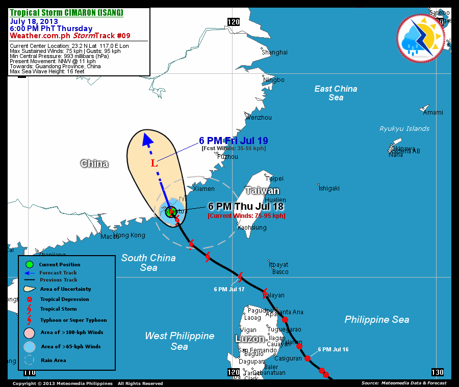
As of 6:00 pm today, the center of TS Cimaron (Isang) was located along the coast of Eastern Guangdong...about 45 km southeast of Shantou City, China or 305 km east-northeast of Hong Kong...currently moving north-northwest with a decreased forward speed of 11 km/hr in the general direction of Eastern Guangdong.
Maximum Sustained Winds (1-min. avg) remain near 75 km/hr near the center with higher gusts. Tropical Storm Force Winds (62-95 km/hr) extend outward up to 75 kilometers from the center. Cimaron (Isang) is a small-sized tropical cyclone with a diameter of 335 kilometers across. The 24-hour rainfall accumulation near the center of Cimaron (Isang) is estimated to be extreme (400 mm).
1-DAY FORECAST OUTLOOK*
TS Cimaron (Isang) is expected to continue moving north-northwest throughout the forecast period. On the forecast track, the core of Cimaron (Isang) will make landfall over Eastern Guangdong very near Shantou City tonight and will continue to move overland across the southern part of Jiangxi Province, Southern China on Friday.
Cimaron (Isang) will gradually weaken overnight as it makes landfall and move across land. Advance Intensity Forecast (AIF) shows the system dissipating into an area of low pressure by Friday evening.
The following is the summary of the 1-day forecast outlook on this system:
 FRIDAY EVENING: Just an area of low pressure moving across Southern Jiangxi...about 220 km west-northwest of Xiamen, China [6PM JULY 19: 25.5N 116.2E @ 35kph].
*Please be reminded that the Forecast Outlook changes every 6 hours, and the Day 3 Forecast Track have an average error of 250 km...while the wind speed forecast error, averages 35 kph per day. Therefore, a turn to the left or right of its future track and changes in its wind speed must be anticipated from time to time.
EFFECTS & HAZARDS SUMMARY
Below is the summary of the storm's parts and its hazards affecting specific areas. You can also view this image link for you to understand the parts.
INNER RAINBANDS - where Tropical Storm Conditions with Tropical Storm Force Winds (63-85 kph) will be expected. Affected Areas: Coastal areas of Eastern Guangdong. OUTER RAINBANDS - where Tropical Depression Conditions with light, moderate to strong winds (30-62 kph) will be expected. Affected Areas: The rest of the coastal areas of Guangdong and Southern Fujian, Taiwan Strait, and the Northern part of the South China Sea. (click here to know more about Rainbands) 24HR TOTAL RAINFALL ACCUMULATION - from 5 up to 100 mm (slight to heavy rainfall) can be expected along areas affected by the outer & inner rainbands (see above)...with isolated amounts of 101 to 400 mm (heavy) along areas to the east and near the center of Cimaron (Isang).
Important Note: Please keep in mind that the above forecast outlook, effects and hazards summary changes every 6 to 12 hrs!
CURRENT TECHNICAL INFORMATION
Time/Date: 6:00 PM PhT Thu July 18, 2013
Class/Name: TS Cimaron (Isang)
Location of Center: 23.2º N Lat 117.0º E Lon
Distance 1: 45 km SE of Shantou, China
Distance 2: 190 km SW of Xiamen, China
Distance 3: 345 km WNW of Kaohsiung, Taiwan
Distance 4: 305 km ENE of Hong Kong
MaxWinds (1-min avg): 75 kph near the center
Peak Wind Gusts: 95 kph
Present Movement: NNW @ 11 kph
Towards: Eastern Guangdong
24hr Rainfall Accum (near center): Extreme [400 mm]
Minimum Central Pressure: 993 millibars (hPa)
Size (in Diameter): 335 km [Small]
Max Sea Wave Height (near center): 16 feet
Possible Storm Surge Height: 0 ft (0 m)
T2K/WP StormTracks (for Public): GIF | Google Map (Flash)
CURRENT TRACKING MAP:
 _____________________________________________________________________________
__________________________________________________________________________________________________
CURRENT NOAA/MTSAT-2 INFRARED (IR) SATELLITE IMAGE:

__________________________________________________________________________________________________
>> To know the meteorological terminologies and acronyms used on this update visit the ff:
http://typhoon2000.ph/tcterm.htm
http://www.nhc.noaa.gov/aboutgloss.shtml
http://www.nhc.noaa.gov/acronyms.shtml
__________________________________________________________________________________________
For the complete details on TS CIMARON (ISANG)...go visit our website @:
> http://www.typhoon2000.com
> http://www.maybagyo.com
<<<Typhoon2000.com Mobile >>>
Get the latest SMS Storm Alerts!
For more details: Text T2K TYPHOON to
2800 (Globe/TM) | Offline (Smart/TNT) | 2288 (Sun)
*Only P2.50 (Smart/Globe) / P2.00 (Sun) per msg received.
Click here on how to use this service (in PDF file)
Powered by: Synermaxx Corporation
Copyright © 2013 Typhoon2000.com All Rights Reserved
| Reply via web post | Reply to sender | Reply to group | Start a New Topic | Messages in this topic (1) |

No comments:
Post a Comment