
WEATHER.COM.PH TROPICAL CYCLONE UPDATES
TROPICAL STORM RUMBIA (GORIO) UPDATE NUMBER 012
Issued: 7:00 AM PhT (23:00 GMT) Tuesday 02 July 2013
Next Update: 7:00 PM PhT (11:00 GMT) Tuesday 02 July 2013
Typhoon RUMBIA (GORIO) has made landfall over Leizhou Peninsula (Western Guangdong), just to the southwest of Zhanjiang City...downgraded to a Tropical Storm as it heads for Guangxi Province.
Residents and visitors along Northern Vietnam, Southern China particularly Western Guangdong should closely monitor the development of RUMBIA (GORIO).
Do not use this for life or death decision. This update is intended for additional information purposes only. Kindly refer to your national weather agency for official warnings, advisories or bulletins.
CURRENT STORM ANALYSIS
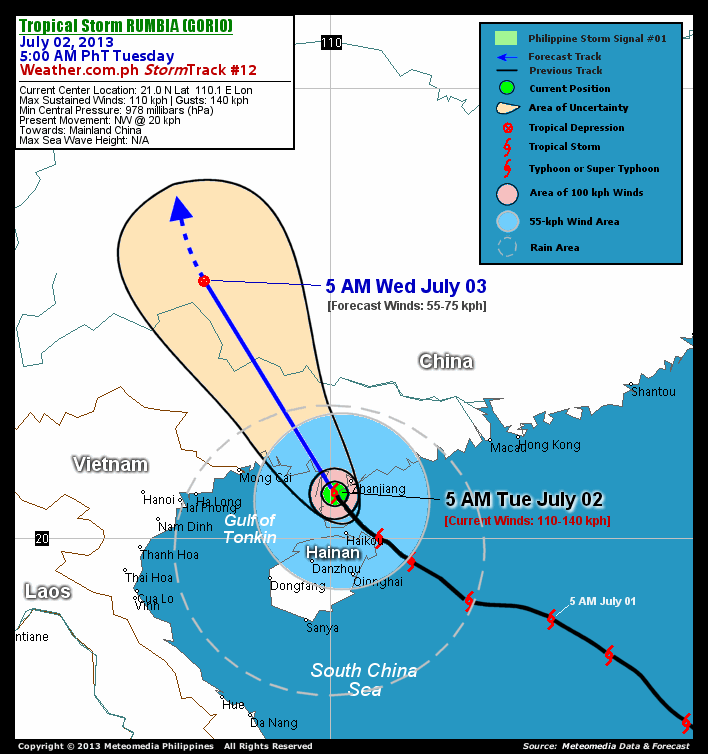
As of 5:00 am today, the center of TS Rumbia (Gorio) was located over Leizhou Peninsula...about 53 km southwest of Zhanjiang City, China or 105 km north-nothwest of Haikou, Hainan Island...currently moving northwest with a decreased forward speed of 20 km/hr in the general direction of Guangxi Province.
Maximum Sustained Winds (1-min. avg) have decreased to 110 km/hr near the center with higher gusts. Tropical Storm Force Winds (62-117 km/hr) extend outward up to 55 kilometers from the center. Rumbia (Gorio) remains an average-sized tropical cyclone with a diameter of 390 kilometers across. The 24-hour rainfall accumulation near the center of Rumbia (Gorio) is estimated to be heavy (220 mm).
1-DAY FORECAST OUTLOOK*
TS Rumbia (Gorio) is expected to continue moving northwestward during the next 24 hours. On the forecast track, the core of Rumbia (Gorio) will move over land across Guangxi Province today through Wednesday.
Rumbia (Gorio) is forecast to gradually weaken into a Tropical Depression (TD) within the next 24 hours due to effects of land interaction and unfavorable upper-level winds. It will dissipate into an area of low pressure on Wednesday afternoon.
The following is the summary of the 1-day forecast outlook on this system:
 WEDNESDAY MORNING: Downgraded to a TD as it moves across Guangxi Province...about 474 km north-northwest of Mong Cai, Vietnam [5AM JULY 03: 25.7N 107.2E @ 55kph].
*Please be reminded that the Forecast Outlook changes every 6 hours, and the Day 3 Forecast Track have an average error of 250 km...while the wind speed forecast error, averages 35 kph per day. Therefore, a turn to the left or right of its future track and changes in its wind speed must be anticipated from time to time.
EFFECTS & HAZARDS SUMMARY
Below is the summary of the storm's parts and its hazards affecting specific areas. You can also view this image link for you to understand the parts.
DECAYING EYEWALL - over land (Southern China). Affected Areas: Northern part of the Leizhou Peninsula. Near-Typhoon Conditions with Near-Typhoon Force Winds (95-117 kph) will be expected within this wall (click here to know more about the Eyewall). INNER RAINBANDS - over land (Southern China) & coastal waters of Western Guangdong and the northern part of the Gulf of Tonkin. Affected Areas: Northern part of Hainan Island, Zhanjiang District Area and the Southern part of Leizhou Peninsula. Tropical Storm Conditions with Tropical Storm Force Winds (63-118 kph) will be expected along these bands. OUTER RAINBANDS - over land (Southern China) and water (Rest of Gulf of Tonkin & the Northwestern part of South China Sea). Affected Areas: Rest of Western Guangdong and Hainan Island and Southern Guangxi. Tropical Depression Conditions with light, moderate to strong winds (30-62 kph) will be expected along these bands (click here to know more about Rainbands). 24HR TOTAL RAINFALL ACCUMULATION - from 5 up to 100 mm (slight to heavy rainfall) can be expected along areas affected by the outer & inner rainbands (see above)...with isolated amounts of 101 to 220 mm (heavy) along areas to the west, north and near the center of Rumbia (Gorio).
Important Note: Please keep in mind that the above forecast outlook, effects and hazards summary changes every 6 to 12 hrs!
CURRENT TECHNICAL INFORMATION
Time/Date: 5:00 AM PhT Tue July 02, 2013
Class/Name: TS Rumbia (Gorio)
Location of Eye: 21.0º N Lat 110.1º E Lon
Distance 1: 53 km SW of Zhanjiang City
Distance 2: 105 km NNW of Haikou, Hainan Is.
Distance 3: 204 km NNW of Qionghai, Hainan Is.
Distance 4: 225 km ESE of Mong Cai, Vietnam
Distance 5: 386 km WSW of Macau
Distance 6: 444 km WSW of Hong Kong
MaxWinds (1-min avg): 110 kph near the center
Peak Wind Gusts: 140 kph
Present Movement: NW @ 20 kph
Towards: Guangxi Province
24hr Rainfall Accum (near center): Heavy [220 mm]
Minimum Central Pressure: 978 millibars (hPa)
Size (in Diameter): 390 km [Average]
Max Sea Wave Height (near center): N/A
Possible Storm Surge Height: 1-3 ft (0.3-0.9 m)
T2K/WP StormTracks (for Public): GIF | Google Map (Flash)

CURRENT NOAA/MTSAT-2 INFRARED (IR) SATELLITE IMAGE:

CURRENT TRACKING MAP:
 _____________________________________________________________________________
>> To know the meteorological terminologies and acronyms used on this update visit the ff:
http://typhoon2000.ph/tcterm.htm
http://www.nhc.noaa.gov/aboutgloss.shtml
http://www.nhc.noaa.gov/acronyms.shtml
__________________________________________________________________________________________
For the complete details on TS RUMBIA (GORIO)...go visit our website @:
> http://www.typhoon2000.com
> http://www.maybagyo.com
<<<Typhoon2000.com Mobile >>>
Get the latest SMS Storm Alerts!
For more details: Text T2K TYPHOON to
2800 (Globe/TM) | Offline (Smart/TNT) | 2288 (Sun)
*Only P2.50 (Smart/Globe) / P2.00 (Sun) per msg received.
Click here on how to use this service (in PDF file)
Powered by: Synermaxx Corporation
Copyright © 2013 Typhoon2000.com All Rights Reserved
| Reply via web post | Reply to sender | Reply to group | Start a New Topic | Messages in this topic (1) |

No comments:
Post a Comment