
for Thursday, 08 August 2013 [8:35 AM PhT]
WEATHER.COM.PH TROPICAL CYCLONE UPDATES
TROPICAL DEPRESSION MANGKHUT (KIKO) UPDATE NUMBER 005 [FINAL]
Issued: 7:00 AM PhT (23:00 GMT) Thursday 08 August 2013
MANGKHUT (KIKO) dissipating over land...just a Tropical Depression (TD)...now over Northern Laos after crossing Northern Vietnam during the past 12 hours. Its rainbands will continue to bring heavy rains across the area.
*This is the last and final update on Mangkhut (Kiko).
Do not use this for life or death decisions. This update is intended for additional information purposes only. Kindly refer to your national weather agency for official warnings, advisories or bulletins.
CURRENT STORM ANALYSIS
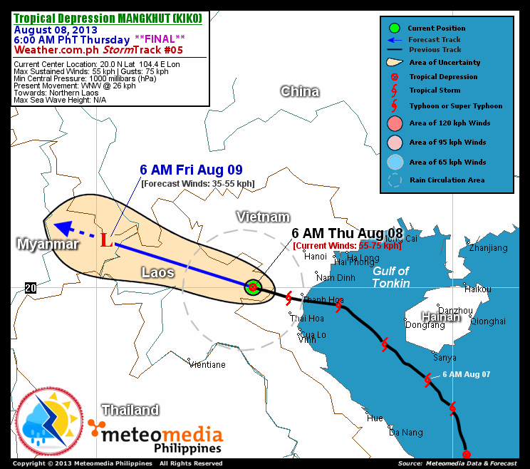
As of 6:00 am today, the center of TD Mangkhut (Kiko) was located over the northern part of Laos...about 150 km west-northwest of Thanh Hoa, Vietnam or 190 km southwest of Hanoi, Vietnam...currently moving west-northwest with an increased forward speed of 26 km/hr towards Myanmar.
Maximum Sustained Winds (1-min. avg) have decreased to near 55 km/hr near the center with higher gusts. Mangkhut (Kiko) has increased to to an average-sized tropical cyclone with a diameter of 370 kilometers across. The 24-hour rainfall accumulation near the center of Mangkhut (Kiko) is estimated to be heavy (300 mm).
1-DAY FORECAST OUTLOOK*
TD Mangkhut (Kiko) is expected to continue moving west-northwestward throughout the forecast period. On the forecast track, the core of Mangkhut (Kiko) will cross Northern Laos today...and will be over Eastern Myanmar on Friday morning.
Mangkhut (Kiko) is expected to dissipate within the next 6 to 24 hours. Advance Intensity Forecast (AIF) shows the depression dissipating into a remnant low pressure as it traverses Eastern Myanmar on Friday morning.
The following is the summary of the 1-day forecast outlook on this system:
 FRIDAY MORNING: Over Eastern Myanmar...weakens into an area of low pressure...dissipating over land...about 440 km northeast of Vientiane, Laos [6AM AUGUST 09: 21.3N 100.3E @ 35kph].
*Please be reminded that the Forecast Outlook changes every 6 hours, and the Day 2 and 3 Forecast Tracks have an average error of 100 and 250 km respectively...while the wind speed forecast error, averages 35 kph per day. Therefore, a turn to the left or right of its future track and changes in its wind speed must be anticipated from time to time.
EFFECTS & HAZARDS SUMMARY
Below is the summary of the storm's parts and its hazards affecting specific areas. You can also view this image link for you to understand the parts.
DECAYING RAINBANDS - where Tropical Depression Conditions with light, moderate to strong winds (30-62 kph) will be expected. Affected Areas: Northern Vietnam and Northern Laos. (click here to know more about Rainbands) 24HR TOTAL RAINFALL ACCUMULATION - from 5 up to 100 mm (slight to heavy rainfall) can be expected along areas affected by the outer & inner rainbands (see above)...with isolated amounts of 101 to 300 mm (heavy) along areas to the south, west and near the center of Mangkhut (Kiko).
Important Note: Please keep in mind that the above forecast outlook, effects and hazards summary changes every 6 to 12 hrs!
CURRENT TECHNICAL INFORMATION
Time/Date: 6:00 AM PhT Thu Aug 08, 2013
Class/Name: TD Mangkhut (Kiko)
Location of Center: 20.0º N Lat 104.4º E Lon
Distance 1: 150 km WNW of Thanh Hoa, Vietnam
Distance 2: 190 km SW of Hanoi, Vietnam
Distance 3: 195 km WSW of Nam Dinh, Vietnam
Distance 4: 290 km NE of Vientiane, Laos
MaxWinds (1-min avg):55 kph near the center
Peak Wind Gusts: 75 kph
Present Movement: WNW @ 26 kph
Towards: Myanmar
24hr Rainfall Accum (near center): Heavy [300 mm]
Minimum Central Pressure: 1000 millibars (hPa)
Size (in Diameter): 370 km [Average]
T2K/WP StormTracks (for Public): GIF | Google Map (Flash)
CURRENT TRACKING MAP:
 _____________________________________________________________________________
__________________________________________________________________________________________________
CURRENT NOAA/MTSAT-2 INFRARED (IR) SATELLITE IMAGE:

__________________________________________________________________________________________________
>> To know the meteorological terminologies and acronyms used on this update visit the ff:
http://typhoon2000.ph/tcterm.htm
http://www.nhc.noaa.gov/aboutgloss.shtml
http://www.nhc.noaa.gov/acronyms.shtml
__________________________________________________________________________________________
For the complete details on TD MANGKHUT (KIKO)...go visit our website @:
> http://www.typhoon2000.com
> http://www.maybagyo.com
<<<Typhoon2000.com Mobile >>>
Get the latest SMS Storm Alerts!
For more details: Text T2K TYPHOON to
2800 (Globe/TM) | Offline (Smart/TNT) | 2288 (Sun)
*Only P2.50 (Smart/Globe) / P2.00 (Sun) per msg received.
Click here on how to use this service (in PDF file)
Powered by: Synermaxx Corporation
Copyright © 2013 Typhoon2000.com All Rights Reserved
| Reply via web post | Reply to sender | Reply to group | Start a New Topic | Messages in this topic (1) |

No comments:
Post a Comment