
for Saturday, 03 August 2013 [9:09 AM PhT]
WEATHER.COM.PH TROPICAL CYCLONE UPDATES
TROPICAL STORM JEBI (JOLINA) UPDATE NUMBER 007
Issued: 7:00 AM PhT (23:00 GMT) Saturday 03 August 2013
Next Update: 7:00 PM PhT (11:00 GMT) Saturday 03 August 2013
Tropical Storm JEBI (JOLINA) fast approaching the northernmost part of Vietnam as it weakens while over the Gulf of Tonkin...landfall likely this morning. Strong winds with heavy rains expected along Mong Cai-Ha Long Area.
This storm will continue to enhance the Southwest Monsoon (Hanging Habagat) bringing cloudy conditions with occasionally slight to moderate to sometimes heavy rains and thunderstorms across Laos, Cambodia and Vietnam. Flash floods and landslides are likely in hazard-prone areas especially along mountain slopes.
Meanwhile, Tropical Disturbance 94W (LPA) located over the southeastern Philippine Sea, east of Davao Oriental - remains not well organized as it approaches Eastern Mindanao. Latest dynamic forecast models show the system becoming a Tropical Depression (TD) once it reaches the Sulu Sea or West Philippine Sea by Sunday or Monday. Its developing center was located about 540 km ESE of Mati City, Davao Oriental (5.8N Lat 131.0E Lon)...with maximum winds of 35 km/hr near the center...moving West @ 26 kph towards Northern Mindanao-Visayas Area. This disturbance has a medium chance (30-50%) of developing into a Tropical Cyclone within the next 24 hours. Its rainbands embedded within the ITCZ will bring cloudy skies with moderate to heavy rains and thunderstorms along the Bicol Region, Visayas and Mindanao today.
Residents and visitors along Southwestern China and Northern Vietnam should closely monitor the development of Jebi (Jolina).
Do not use this for life or death decisions. This update is intended for additional information purposes only. Kindly refer to your national weather agency for official warnings, advisories or bulletins.
CURRENT STORM ANALYSIS
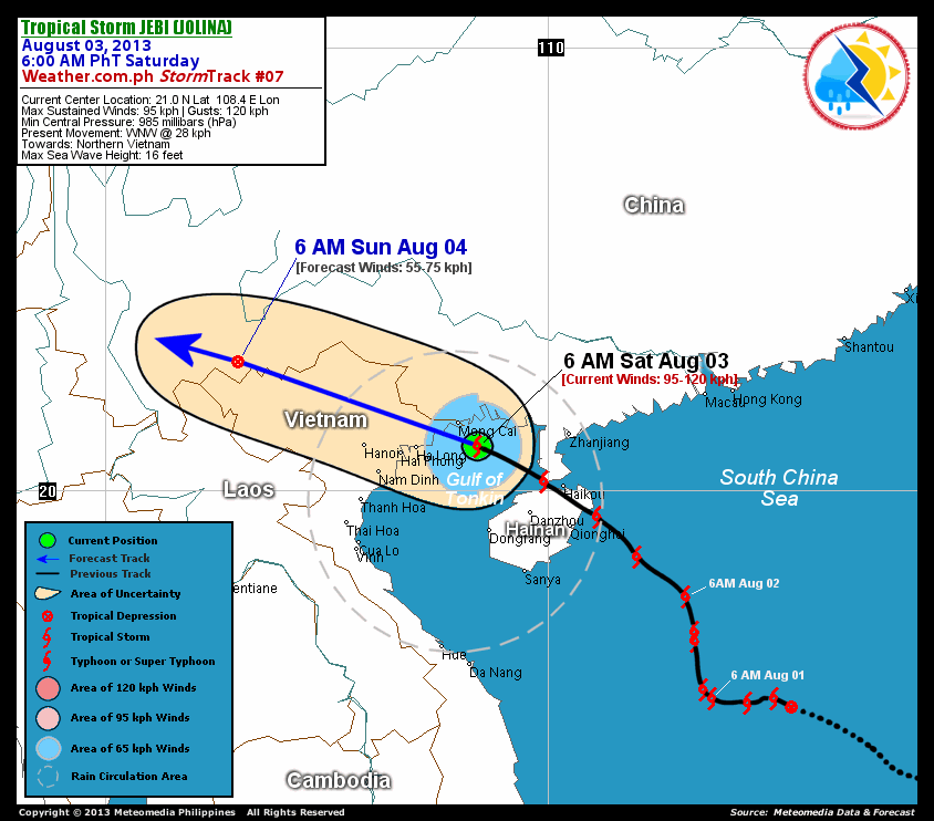
As of 6:00 am today, the center of TS Jebi (Jolina) was located over the Gulf of Tonkin...about 70 km southeast of Mong Cai, Vietnam or 210 km northwest of Danzhou, Hainan Island...currently moving west-northwest with an increased forward speed of 28 km/hr towards the northernmost part of Vietnam.
Maximum Sustained Winds (1-min. avg) have decreased to near 95 km/hr near the center with higher gusts. Tropical Storm Force Winds (63-110 km/hr) extend outward up to 130 kilometers from the center. Jebi (Jolina) has reduced to an average-sized tropical cyclone with a diameter of 520 kilometers across. The 24-hour rainfall accumulation near the center of Jebi (Jolina) is estimated to be extreme (400 mm).
1-DAY FORECAST OUTLOOK*
TS Jebi (Jolina) is expected to continue moving west-northwest throughout the forecast period. On the forecast track, the core of Jebi (Jolina) will make landfall over Northern Vietnam later this morning and cross the rugged terrain of the area throughout today. On Sunday morning, Jebi (Jolina) will be over the Vietnam-China Border.
Jebi (Jolina) is expected to gradually weaken within the next 12 hours as it makes landfall over Northern Vietnam. Advance Intensity Forecast (AIF) shows the storm weakening to 75 km/hr on Saturday afternoon...and dissipating into a Tropical Depression (TD) on Sunday morning.
The following is the summary of the 1-day forecast outlook on this system:
 SUNDAY MORNING: Over the Vietnam-China Border...about 365 km west-northwest of Hanoi City, Vietnam [6AM AUGUST 04: 22.9N 103.0E @ 55kph].
*Please be reminded that the Forecast Outlook changes every 6 hours, and the Day 2 and 3 Forecast Tracks have an average error of 100 and 250 km respectively...while the wind speed forecast error, averages 35 kph per day. Therefore, a turn to the left or right of its future track and changes in its wind speed must be anticipated from time to time.
EFFECTS & HAZARDS SUMMARY
Below is the summary of the storm's parts and its hazards affecting specific areas. You can also view this image link for you to understand the parts.
CENTRAL DENSE OVERCAST (CDO) - where Near-Typhoon Conditions w/ Near-Typhoon Force Winds (100-120 kph) will be expected along the CDO (click here to know more about CDO). Possible "Eye" may also be forming underneath the cirrus canopy. Affected Areas: Coastal areas of Mong Cai and Ha Long Vietnam and the Northern part of Gulf of Tonkin. INNER RAINBANDS - where Tropical Storm Conditions with Tropical Storm Force Winds (63-99 kph) will be expected. Affected Areas: The rest of the Gulf of Tonkin, Southwesternmost part of Guangdong Province and the Northeastern part of Northern Vietnam. OUTER RAINBANDS - where Tropical Depression Conditions with light, moderate to strong winds (30-55 kph) will be expected. Affected Areas: Rest of Northern Vietnam, Hainan Island and Western Guangdong. (click here to know more about Rainbands) 24HR TOTAL RAINFALL ACCUMULATION - from 5 up to 200 mm (slight to heavy rainfall) can be expected along areas affected by the outer & inner rainbands (see above)...with isolated amounts of 201 to 400 mm (heavy to extreme) along areas to the south, west and near the center of Jebi (Jolina).
Important Note: Please keep in mind that the above forecast outlook, effects and hazards summary changes every 6 to 12 hrs!
CURRENT TECHNICAL INFORMATION
Time/Date: 6:00 AM PhT Sat Aug 03, 2013
Class/Name: TS Jebi (Jolina)
Location of Center: 21.0º N Lat 108.4º E Lon
Distance 1: 70 km SE of Mong Cai, Vietnam
Distance 2: 145 km E of Ha Long, Vietnam
Distance 3: 210 km NW of Danzhou, Hainan Is.
Distance 4: 210 km WSW of Zhanjiang, China
Distance 5: 270 km E of Hanoi, Vietnam
MaxWinds (1-min avg):95 kph near the center
Peak Wind Gusts: 120 kph
Present Movement: WNW @ 28 kph
Towards: Northern Vietnam
24hr Rainfall Accum (near center): Extreme [400 mm]
Minimum Central Pressure: 985 millibars (hPa)
Size (in Diameter): 520 km [Average]
Max Sea Wave Height (near center): 23 feet
Possible Storm Surge Height: 1-3 ft (0.3-0.9 m)
T2K/WP StormTracks (for Public): GIF | Google Map (Flash)
CURRENT TRACKING MAP:
 _____________________________________________________________________________
__________________________________________________________________________________________________
CURRENT NOAA/MTSAT-2 INFRARED (IR) SATELLITE IMAGE:

__________________________________________________________________________________________________
>> To know the meteorological terminologies and acronyms used on this update visit the ff:
http://typhoon2000.ph/tcterm.htm
http://www.nhc.noaa.gov/aboutgloss.shtml
http://www.nhc.noaa.gov/acronyms.shtml
__________________________________________________________________________________________
For the complete details on TS JEBI (JOLINA)...go visit our website @:
> http://www.typhoon2000.com
> http://www.maybagyo.com
<<<Typhoon2000.com Mobile >>>
Get the latest SMS Storm Alerts!
For more details: Text T2K TYPHOON to
2800 (Globe/TM) | Offline (Smart/TNT) | 2288 (Sun)
*Only P2.50 (Smart/Globe) / P2.00 (Sun) per msg received.
Click here on how to use this service (in PDF file)
Powered by: Synermaxx Corporation
Copyright © 2013 Typhoon2000.com All Rights Reserved
| Reply via web post | Reply to sender | Reply to group | Start a New Topic | Messages in this topic (1) |

No comments:
Post a Comment