
for Sunday, 06 October 2013 [10:54 AM PhT]
WEATHER.COM.PH TROPICAL CYCLONE UPDATES
TYPHOON FITOW (QUEDAN) UPDATE NUMBER 011
Issued at: 8:15 AM PhT (00:15 GMT) Sunday 06 October 2013
Typhoon FITOW (QUEDAN) has weakened sligthly and is now moving west-northwest across the Southern East China Sea towards Southeastern China threatening Fujian-Zhejiang Area.
Meanwhile, Tropical Storm 23W (DANAS) has intensified into a Typhoon. At 5:00 am today, its center was located about 610 km SW of Iwo To Island or 1,145 km SE of Okinawa, Japan (Near 20.8N Lat 137.2E Lon)...with maximum winds of 130 km/hr near the center...currently moving NW at a very fast speed 0f 35 kph in the general directon of southern islands of Japan. Various forecast models suggest this system will enter the northeastern border of the Philippine Area of Responsibility (PAR) this afternoon.
Residents and visitors along the southern islands of Japan, Northern Taiwan and Eastern China. should closely monitor the development of FITOW (Quedan).
Do not use this for life or death decisions. This update is intended for additional information purposes only. Kindly refer to your national weather agency for official warnings, advisories or bulletins.
CURRENT STORM ANALYSIS
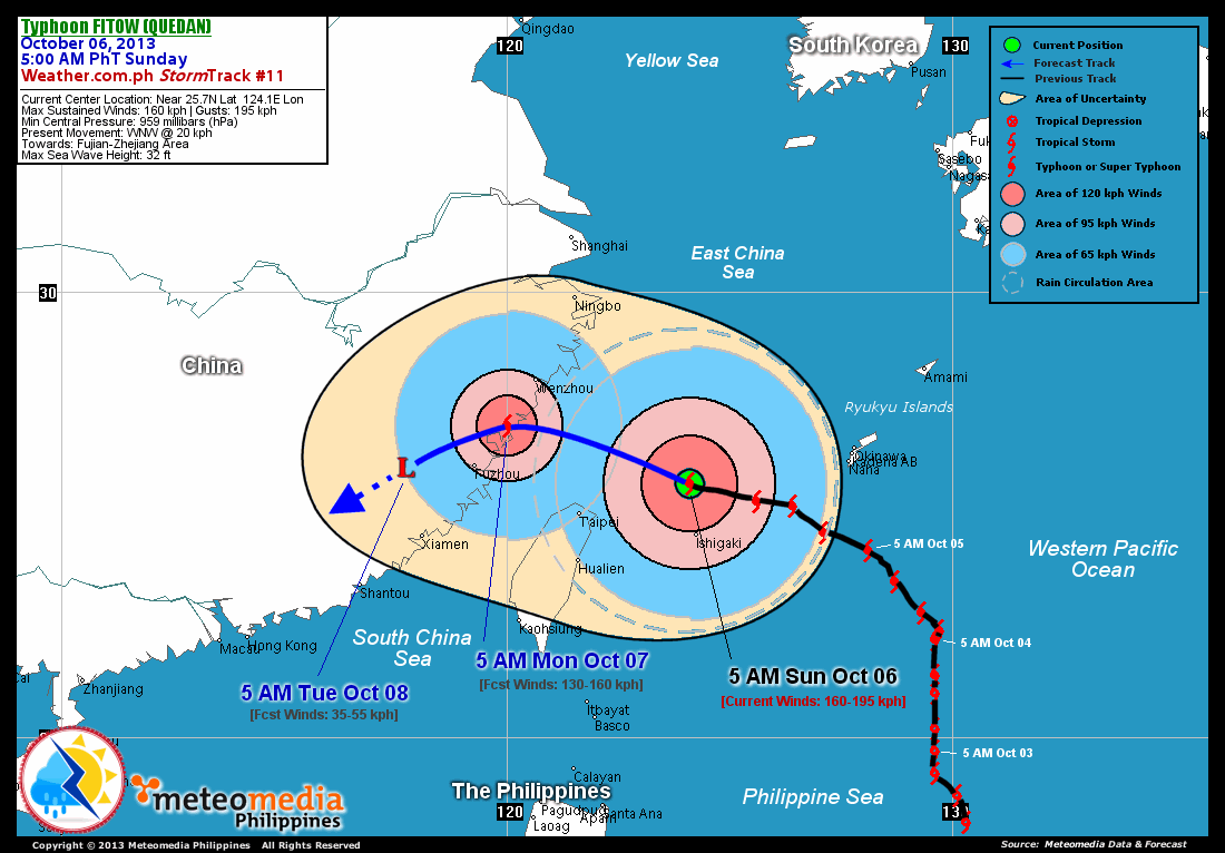
As of 5:00 am today, the eye of TY Fitow (Quedan) was located over the Southern East China Sea...about 135 km north-northwest of Ishigaki City or 265 km east-northeast of Taipei, Taiwan...currently moving west-northwest with a forward speed of 20 km/hr towards Fujian-Zhejiang Area.
Maximum Sustained Winds (1-min. avg) are at 160 km/hr near the center with higher gusts. Typhoon Force Winds (118 km/hr or more) extend outward up to 120 kilometers from the center...and Tropical Storm Force Winds (63-117 km/hr) extend outward up to 340 kilometers. Fitow (Quedan) remains a large-sized tropical cyclone with a diameter of 835 kilometers across. The 24-hour rainfall accumulation near the center of Fitow (Quedan) is estimated to be heavy (325 mm).
2-DAY FORECAST OUTLOOK*
TY Fitow (Quedan) is expected to move west-northwest to west during the next 24 hours...then turns to the west-southwest to southwest through 48 hours. On the forecast track, the remnants of Fitow (Quedan) will be over Central Fujian, China on Tuesday morning.
TY Fitow (Quedan) is expected to weaken throughout the forecast period. Advance Intensity Forecast (AIF) shows its 1-minute maximum sustained winds significantly decrease to 35 km/hr by Tuesday early morning.
The following is the summary of the 2-day forecast outlook on this system:
 MONDAY MORNING: Weakens to Category 1 Typhoon...as it makes landfall over Northeastern Fujian...about 130 km northeast of Fuzhou City [5AM OCT 07: 27.0 120.0E @ 130kph].
TUESDAY MORNING: Weakens to an Area of Low Pressure...as it moves south across Central Fujian...about 170 km west-southwest of Fuzhou City, China [5AM OCT 08: 26.0N 117.6E @ 35kph].
*Please be reminded that the Forecast Outlook changes every 6 hours, and the Day 2 and 3 Forecast Tracks have an average error of 100 and 250 km respectively...while the wind speed forecast error, averages 35 kph per day. Therefore, a turn to the left or right of its future track and changes in its wind speed must be anticipated from time to time.
EFFECTS & HAZARDS SUMMARY
Below is the summary of the storm's parts and its hazards affecting specific areas. You can also view this image link for you to understand the parts.
RAGGED EYE - Over the Southern East China Sea. Possible calm and lull conditions (with <20 kph winds) will be expected inside the eye (click here to know more about the EYE). EYEWALL - where Typhoon Conditions with Typhoon Force Winds (>118 kph) will be expected within this wall. Affected Areas: Southern East China Sea (click here to know more about the Eyewall). INNER RAINBANDS - where Tropical Storm Conditions with Tropical Storm Force Winds (63-100 kph) will be expected. Affected Areas: Southern East China Sea. OUTER RAINBANDS - where Tropical Depression Conditions with light, moderate to strong winds (30-62 kph) will be expected. Affected Areas: Southern East China Sea, Southwestern portion of Ryukyu Sea and Northern East Taiwan Sea (click here to know more about Rainbands). 24HR TOTAL RAINFALL ACCUMULATION - from 5 up to 100 mm (slight to heavy rainfall) can be expected along areas affected by the outer & inner rainbands (see above)...with isolated amounts of 101 to 325 mm (heavy) along areas near the center of Fitow (Quedan). COASTAL STORM SURGE FLOODING - possible 6-8 ft (1.8-2.6 m) above normal tide levels...accompanied by large and dangerous battering waves can be expected along the coastal, inland lakes and beach front areas of Northern Taiwan and SE China today. Moderate damage is likely on this type of storm surge. Danger from Rip Currents or Rip Tides can be expected along the beach-front areas of Taiwan, Eastern and Southern China (click here to know more about Storm Surge).
Important Note: Please keep in mind that the above forecast outlook, effects and hazards summary changes every 6 to 12 hrs!
CURRENT TECHNICAL INFORMATION
Time/Date: 5:00 AM PhT Sun Oct 06, 2013
Class/Name: TY Fitow (Quedan)
Location of Center: Near 25.7º N Lat 124.1º E Lon
Distance 1: 135 km NNW of Ishigaki City, Japan
Distance 2: 265 km ENE of Taipei, Taiwan
Distance 3: 365 km WNW of Naha City, Japan
Distance 4: 480 km E of Fuzhou City, China
Distance 5: 425 km SE of Wenzhou City, China
MaxWinds (1-min avg): 160 kph near the center
Peak Wind Gusts: 195 kph
Saffir-Simpson Hurricane Scale: Category 2
Present Movement: WNW @ 20 kph
Towards: Fujian-Zhejiang Area
CPA [ETA] to Northeastern Fujian: Monday, between 3AM to 6AM
24hr Rainfall Accum (Near the Center): Heavy [325 mm]
Minimum Central Pressure: 956 millibars (hPa)
Size (in Diameter): 835 km [Large]
Max Sea Wave Height (near center): 32 feet
Possible Storm Surge Height: 6-8 ft (1.8-2.6 m)
T2K/WP StormTracks (for Public): GIF | Google Map (Flash)
CURRENT TRACKING MAP:
 _____________________________________________________________________________
__________________________________________________________________________________________________
CURRENT NOAA/MTSAT-2 INFRARED (IR) SATELLITE IMAGE:
 __________________________________________________________________________________________________
 >> To know the meteorological terminologies and acronyms used on this update visit the ff:
http://typhoon2000.ph/tcterm.htm
http://www.nhc.noaa.gov/aboutgloss.shtml
http://www.nhc.noaa.gov/acronyms.shtml
__________________________________________________________________________________________
For the complete details on TY FITOW (QUEDAN)...go visit our website @:
> http://www.typhoon2000.com
> http://www.maybagyo.com
<<<Typhoon2000.com Mobile >>>
Get the latest SMS Storm Alerts!
For more details: Text T2K TYPHOON to
2800 (Globe/TM) | Offline (Smart/TNT) | 2288 (Sun)
*Only P2.50 (Smart/Globe) / P2.00 (Sun) per msg received.
Click here on how to use this service (in PDF file)
Powered by: Synermaxx Corporation
Copyright © 2013 Typhoon2000.com All Rights Reserved
| Reply via web post | Reply to sender | Reply to group | Start a New Topic | Messages in this topic (1) |

No comments:
Post a Comment