
for Saturday, 09 November 2013 [1:53 PM PhT]
WEATHER.COM.PH TROPICAL CYCLONE UPDATES
TYPHOON HAIYAN (YOLANDA) UPDATE NUMBER 015
Issued at: 6:00 AM PhT (22:00 GMT) Saturday 09 November 2013
Next Update: 6:00 PM PhT (10:00 GMT) Saturday 09 November 2013
HAIYAN (YOLANDA) no longer a Super Typhoon (STY) as it weakened while moving fast across the West Philippine and South China Seas...but remains a dangerous Category 4 cyclone. Its Eastern Outer Rainbands continues to spread across Luzon and Western Visayas.
Residents and visitors along Vietnam and Laos should closely monitor the development of Haiyan (Yolanda).
Do not use this for life or death decisions. This update is intended for additional information purposes only. Kindly refer to your national weather agency for official warnings, advisories or bulletins.
CURRENT STORM ANALYSIS
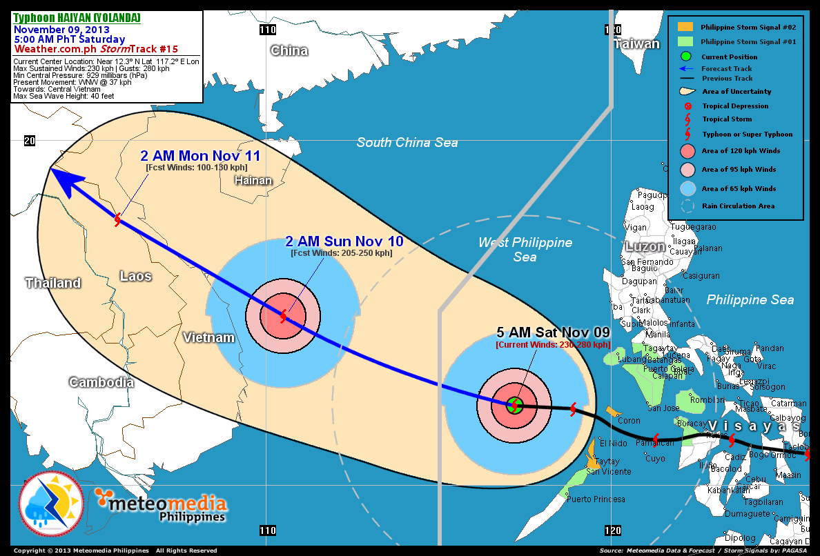
As of 5:00 am today, the eye of TY Haiyan (Yolanda) was located over West Philippine Sea...about 330 km west-northwest of Coron, Palawan or 290 km west-northwest of El Nido, Palawan...currently moving very quickly west to west-northwest with a forward speed of 31 km/hr towards Central Vietnam.
Maximum Sustained Winds (1-min. avg) have decreased to 230 km/hr near the center with higher gusts. Typhoon Force Winds (118 km/hr or more) extend outward up to 85 kilometers from the center...and Tropical Storm Force Winds (63-117 km/hr) extend outward up to 240 kilometers. STY Haiyan remains an average-sized tropical cyclone with an increased diameter of 835 kilometers across.
2-DAY FORECAST OUTLOOK*
TY Haiyan is expected to continue moving rapidly in a west-northwest track within the next 24 hours...turning northwest through 48 hours. On the forecast track, the core of TY Haiyan will continue cruising fast across the West Philippine Sea today and will move out of the Philippine Area of Responsibility (PAR) this afternoon. On Sunday early morning, the powerful typhoon will be approaching the coastal areas of Central Vietnam...making landfall along the north central part of Vietnam on Sunday afternoon or evening.
TY Haiyan (Yolanda) will continue losing strength within the next 24 through 48 hours as the system traverses the slightly cooler West Philippine and South China Seas...and will be just a Tropical Storm (TS) on Sunday afternoon or evening as the system makes landfall over Central Vietnam. Advance Intensity Forecast (AIF) shows its 1-minute maximum sustained winds decreasing to just 100 km/hr by early Sunday morning.
The following is the summary of the 2-day forecast outlook on this system:
 SUNDAY EARLY MORNING: Weakens to a Category 3 Typhoon as it approaches the Central Vietnam...about 280 km SE of Da Nang, Vietnam [2AM NOV 10: 14.9N 110.5E @ 205kph].
MONDAY EARLY MORNING: Over North Central Vietnam...weakens to TS...about 110 km S of Hue, Vietnam [2AM NOV 11: 17.7N 105.7E @ 100kph].
*Please be reminded that the Forecast Outlook changes every 6 hours, and the Day 2 and 3 Forecast Track has an average error of 100 and 250 km respectively...while the wind speed forecast error, averages 35 kph per day. Therefore, a turn to the left or right of its future track and changes in its wind speed must be anticipated from time to time.
EFFECTS & HAZARDS SUMMARY
Below is the summary of the storm's parts and its hazards affecting specific areas. You can also view this image link for you to understand the parts.
CLOUD FILLED EYE - Over the West Philippine Sea. Possible calm and lull conditions (with <20 kph winds) will be expected inside the eye (click here to know more about the EYE). EYEWALL - where Typhoon Conditions with Typhoon Force Winds (>118 kph) will be expected within this wall. Affected Areas: None. (click here to know more about the Eyewall). INNER RAINBANDS - where Tropical Storm Conditions with Tropical Storm Force Winds (63-100 kph) will be expected. Affected Areas: None. OUTER RAINBANDS - where Tropical Depression Conditions with light, moderate to strong winds (30-62 kph) will be expected. Affected Areas: Western Visayas, MiMaRoPa, rest of Luzon including Bicol Region (click here to know more about Rainbands). 24HR TOTAL RAINFALL ACCUMULATION - from 5 up to 100 mm (slight to heavy rainfall) can be expected along areas affected by the outer & inner rainbands (see above)...with isolated amounts of 101 to 300 mm (heavy to extreme) along areas near the center of Haiyan.
Important Note: Please keep in mind that the above forecast outlook, effects and hazards summary changes every 6 to 12 hrs!
CURRENT TECHNICAL INFORMATION
Time/Date: 5:00 AM PhT Sat Nov 09, 2013
Class/Name: TY Haiyan (Yolanda)
Location of Eye: Near 12.3º N Lat 117.2º E Lon
Distance 1: 330 km WNW of Coron, Palawan
Distance 2: 345 km ENE of Pagasa Is., Spratlys
Distance 3: 290 km WNW of El Nido, Palawan
Distance 4: 365 km WSW of Lubang Island
Distance 5: 495 km SW of Metro Manila
MaxWinds (1-min avg): 230 kph near the center
Peak Wind Gusts: 280 kph
Saffir-Simpson Hurricane Scale: Category 4
Present Movement: W, WNW @ 31 kph
Towards: Central Vietnam>
Minimum Central Pressure: 929 millibars (hPa)
T2K/WP StormTracks (for Public): GIF | Google Map (Flash)
CURRENT TRACKING MAP:
 _____________________________________________________________________________
__________________________________________________________________________________________________
CURRENT NOAA/MTSAT-2 RGB & INFRARED (IR) SATELLITE IMAGES:

 __________________________________________________________________________________________________
 >> To know the meteorological terminologies and acronyms used on this update visit the ff:
http://typhoon2000.ph/tcterm.htm
http://www.nhc.noaa.gov/aboutgloss.shtml
http://www.nhc.noaa.gov/acronyms.shtml
__________________________________________________________________________________________
For the complete details on TY HAIYAN (YOLANDA)...go visit our website @:
> http://www.typhoon2000.com
> http://www.maybagyo.com
<<<Typhoon2000.com Mobile >>>
Get the latest SMS Storm Alerts!
For more details: Text T2K TYPHOON to
2800 (Globe/TM) | Offline (Smart/TNT) | 2288 (Sun)
*Only P2.50 (Smart/Globe) / P2.00 (Sun) per msg received.
Click here on how to use this service (in PDF file)
Powered by: Synermaxx Corporation
Copyright © 2013 Typhoon2000.com All Rights Reserved
| Reply via web post | Reply to sender | Reply to group | Start a New Topic | Messages in this topic (1) |

No comments:
Post a Comment